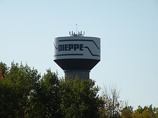
Dieppe is a city in the Canadian maritime province of New Brunswick. Statistics Canada counted the population at 28,114 in 2021, making it the fourth-largest city in the province. On 1 January 2023, Dieppe annexed parts of two neighbouring local service districts; revised census figures have not been released.

Westmorland County is a county in New Brunswick, a province of Canada. It is in the south-eastern part of the province. It contains the fast-growing commercial centre of Moncton and its northern and eastern suburbs. Also located in the county are the university town of Sackville and the local tourist destination of Shediac.

Riverview is a town in Albert County, New Brunswick, Canada. Riverview is located on the south side of the Petitcodiac River, across from the larger cities of Moncton and Dieppe. Riverview has an area of 34 square kilometres (13 sq mi), and a population density of 564.6 inhabitants per square kilometre (1,462/sq mi). Riverview's slogan is "A Great Place To Grow". With a population of 20,584 in 2021,
Haute-Aboujagane is a small Canadian community in Westmorland County, New Brunswick. Formerly a local service district, it was later part of the rural community of Beaubasin East.
Bircham is a hamlet in southern Alberta, Canada within Kneehill County. It is located approximately 78 km (48 mi) northeast of Calgary and 10 km (6.2 mi) southeast of Acme, along a Canadian National Railway line.
Collette is a small rural community in the Northumberland County region of New Brunswick, Canada. The community is settled halfway between Miramichi, and Moncton, off the Route 126, and near Nouvelle-Arcadie.
Nauwigewauk is a rural community in Kings County, New Brunswick, Canada. It is located near the communities of Quispamsis and Lakeside at the mouth of the Hammond River, and borders the town of Hampton. The people of Nauwigewauk are sometimes locally known as Nauwigewaukies.

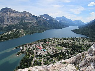
Waterton Park, commonly referred to as Waterton, is a hamlet in southwestern Alberta, Canada within Improvement District No. 4 Waterton.
Josephburg is a hamlet in Alberta, Canada within Strathcona County. It is located on Highway 830, 6.5 kilometres (4.0 mi) east of Fort Saskatchewan. It is near Alberta's Industrial Heartland, home to petrochemical industries.
Harvie Heights is a hamlet in Alberta, Canada, within the Municipal District of Bighorn No. 8. It is located within Alberta's Rockies on the Trans-Canada Highway approximately 4 kilometres (2.5 mi) northwest of Canmore and immediately east of the park gate for Banff National Park.
Linn Valley is a hamlet in central Alberta, Canada within Red Deer County. It is located on Highway 11A, approximately 7 kilometres (4.3 mi) northwest of Red Deer.
Lowland Heights is a hamlet in southern Alberta, Canada within the Municipal District of Pincher Creek No. 9. It is located on Highway 6, approximately 83 kilometres (52 mi) southwest of Lethbridge.
Lyalta is a hamlet in southern Alberta, Canada within Wheatland County. It is located 8 kilometres (5.0 mi) north of Highway 1, approximately 32 kilometres (20 mi) east of Calgary.
Lower Newcastle-Russellville was a local service district in New Brunswick. It is now part of the Greater Miramichi rural district.
Notre-Dame-des-Érables is an unincorporated community in Gloucester County, New Brunswick, on Route 340. The community is within the former local service district of the Paroisse Notre-Dame-des-Érables, which was often shortened to the same name.

Pointe-Sapin is a settlement on the northern coast of New Brunswick, Canada, on the Northumberland Strait in the Gulf of the St. Lawrence. As a designated place in the 2011 Census, it had a population of 350 living in 165 of its 192 total private dwellings. Pointe-Sapin lies in the Atlantic Time Zone (AST/ADT) and observes daylight saving time.

Saint-Simon is a settlement in Gloucester County, New Brunswick, Canada. It is located in the Acadian Peninsula.
Greater Lakeburn was an area with enhanced services within the Canadian local service district of the parish of Moncton in Westmorland County, New Brunswick; it was sometimes erroneously cited as an LSD in its own right. It was situated in Southeastern New Brunswick, to the east of Dieppe. This District contained the southern part of the community of Painsec and Melanson Settlement as well as a mostly treed area. Greater Lakeburn was part of Greater Moncton.
Black River-Hardwicke was a local service district in Northumberland County, New Brunswick. It is now part of the Greater Miramichi rural district.
Benton was a local service district that was partially within Carleton County and partially within York County in the Canadian province New Brunswick. Straddling the boundaries of two parishes – Woodstock and Canterbury – the local service district was divided into two designated places by Statistics Canada.


