Shediac Parish, New Brunswick

Last updated

Shediac
Westmorland County NB - Shediac Parish.png
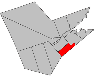
Location within Westmorland County, New Brunswick.
Coordinates: 46°11′N64°36′W / 46.19°N 64.60°W / 46.19; -64.60
Country Flag of Canada (Pantone).svg  Canada
Province Flag of New Brunswick.svg  New Brunswick
County Westmorland County
Erected1827
Area
[1]
  Land178.79 km2 (69.03 sq mi)
Population
 (2021) [1]
  Total5,144
  Density28.8/km2 (75/sq mi)
  Change 2016-2021
Increase2.svg 7.4%
  Dwellings
2,976
Time zone UTC-4 (AST)
  Summer (DST) UTC-3 (ADT)
Figures do not include portions within the city of Dieppe, the town of Shediac, the village of Cap-Pelé, and the rural community of Beaubassin East

Shediac is a geographic parish in Westmorland County, New Brunswick, Canada. [4]

Contents

For governance purposes it is divided between the city of Dieppe, [5] the towns of Cap-Acadie [5] and Shediac, [5] the incorporated rural communities of Beausoleil [6] and Maple Hills, [5] and the Southeast rural district. [lower-alpha 1] Beausoleil is a members of the Kent Regional Service Commission, with the rest all belonging to the Southeast Regional Service Commission. [7]

Prior to the 2023 governance reform, the parish was divided between Dieppe, [8] Shediac, [8] the village of Cap-Pelé, [8] the rural community of Beaubassin East, [9] and the local service districts of Grande-Digue, Pointe-du-Chêne, Scoudouc, Scoudouc Road, Shediac Bridge-Shediac River, Shediac Cape, and the parish of Shediac. [10] With minor boundary changes, Grande-Digue and Shediac Bridge-Shediac River are now part of Beausoleil; Pointe-du-Chêne, Scoudouc, Scoudouc Road, and Shediac Cape were annexed by Shediac; Cap-Pelé and Beaubassin East merged to form Cap-Acadie; and the Shediac Parish LSD was divided between Beausoleil and Maple Hills.

Origin of name

The parish's name comes the community of Shediac, itself from a corruption of Mi'kmaq Es-ed-ei'-ik, translated by Rand as "running far back." There was a Fort Shediac mentioned in documents around 1755, on the mainland opposite Shediac Island. [11]

History

Shediac was erected in 1827 from Dorchester and Sackville Parishes. [12] The eastern boundary was at the mouth of the Kouchibouguac River.

In 1850 the eastern boundary was moved to run through Cap-Pelé. [13]

In 1894 the existing boundaries were declared retroactive to the parish's erection. [14]

In 1904 the boundary with Botsford Parish was clarified. [15]

Boundaries

Shediac Parish is bounded: [2] [16] [17]

Communities

Communities at least partly within the parish. [16] [17] [20] bold indicates an incorporated municipality or rural community; italics indicate a name no longer in official use

Bodies of water

Bodies of water [lower-alpha 4] at least partly within the parish. [16] [17] [20]

Islands

Islands at least partly within the parish. [16] [17] [20]

Other notable places

Parks, historic sites, and other noteworthy places at least partly within the parish. [16] [17] [20]

Demographics

Parish population total does not include the town of Shediac and portions within Dieppe, Cap-Pelé, and Beaubassin East

Access routes

Highways and numbered routes that run through the parish, including external routes that start or finish at the parish limits: [25]

See also

Notes

  1. Maps still visible as thumbnails show the current and previous governance boundaries. [5]
  2. By the magnet of 1903, [15] when declination in the area was between 22º and 23º west of north. [18] The Territorial Division Act clause referring to magnetic direction bearings was omitted in the 1952 [19] and 1973 Revised Statutes. [2]
  3. By the magnet of 1894, [14] when declination in the area was between 21º and 22º west of north. [18]
  4. Not including brooks, ponds or coves.

Related Research Articles

<span class="mw-page-title-main">Moncton Parish, New Brunswick</span> Parish in New Brunswick, Canada

Moncton is a geographic parish in Westmorland County, New Brunswick, Canada.

<span class="mw-page-title-main">Beaubassin East, New Brunswick</span> Place in New Brunswick, Canada

Beaubassin East was an incorporated rural community in Westmorland County, New Brunswick, Canada. It held rural community status prior to 2023 and is now part of the town of Cap-Acadie.

<span class="mw-page-title-main">Dundas Parish, New Brunswick</span> Parish in Canada

Dundas is a geographic parish in Kent County, New Brunswick, Canada.

<span class="mw-page-title-main">Queensbury Parish, New Brunswick</span> Parish in New Brunswick, Canada

Queensbury is a geographic parish in York County, New Brunswick, Canada.

<span class="mw-page-title-main">Sackville Parish, New Brunswick</span> Parish in New Brunswick, Canada

Sackville is a geographic parish in Westmorland County, New Brunswick, Canada.

<span class="mw-page-title-main">Chatham Parish, New Brunswick</span> Parish in New Brunswick, Canada

Chatham is a geographic parish in Northumberland County, New Brunswick, Canada.

<span class="mw-page-title-main">Southesk Parish, New Brunswick</span> Parish in New Brunswick, Canada

Southesk is a geographic parish in Northumberland County, New Brunswick, Canada.

<span class="mw-page-title-main">Rogersville Parish, New Brunswick</span> Parish in New Brunswick, Canada

Rogersville is a geographic parish in Northumberland County, New Brunswick, Canada.

<span class="mw-page-title-main">Carleton Parish, New Brunswick</span> Parish in New Brunswick, Canada

Carleton is a geographic parish in Kent County, New Brunswick, Canada.

<span class="mw-page-title-main">Wellington Parish, New Brunswick</span> Parish in New Brunswick, Canada

Wellington is a geographic parish in Kent County, New Brunswick, Canada.

<span class="mw-page-title-main">Sainte-Marie Parish, New Brunswick</span> Parish in New Brunswick, Canada

Saint-Marie, is a geographic parish in Kent County, New Brunswick, Canada.

<span class="mw-page-title-main">Saint Marys Parish, New Brunswick</span> Parish in New Brunswick, Canada

Saint Marys is a geographic parish in York County, New Brunswick, Canada.

Greater Shediac is the name given to the area encompassing the Town of Shediac in New Brunswick, Canada and its surroundings. Most of this area is a tourist area along the Northumberland Strait mainly on portions of Route 134, Route 133 and Route 950. Some of the areas mentioned below are included in the area of Greater Moncton.

Route 133 is a mostly east/west provincial highway in the Canadian province of New Brunswick.

<span class="mw-page-title-main">Botsford Parish, New Brunswick</span> Parish in New Brunswick, Canada

Botsford is a geographic parish in Westmorland County, New Brunswick, Canada.

<span class="mw-page-title-main">Dorchester Parish, New Brunswick</span> Parish in New Brunswick, Canada

Dorchester is a geographic parish in Westmorland County, New Brunswick, Canada.

<span class="mw-page-title-main">Havelock Parish, New Brunswick</span> Parish in New Brunswick, Canada

Havelock is a geographic parish in Kings County, New Brunswick, Canada.

<span class="mw-page-title-main">Studholm Parish, New Brunswick</span> Parish in New Brunswick, Canada

Studholm is a geographic parish in Kings County, New Brunswick, Canada.

<span class="mw-page-title-main">Norton Parish, New Brunswick</span> Parish in New Brunswick, Canada

Norton is a geographic parish in Kings County, New Brunswick, Canada.

References

  1. 1 2 "Census Profile". Statistics Canada. 26 October 2022. Retrieved 30 October 2022.
  2. 1 2 3 "Chapter T-3 Territorial Division Act". Government of New Brunswick. Retrieved 13 February 2023.
  3. "Chapter I-13 Interpretation Act". Government of New Brunswick. Retrieved 13 February 2023.
  4. The Territorial Division Act [2] divides the province into 152 parishes, the cities of Saint John and Fredericton, and one town of Grand Falls. The Interpretation Act [3] clarifies that parishes include any local government within their borders.
  5. 1 2 3 4 5 "Southeast Regional Service Commission: RSC 7". Government of New Brunswick. Retrieved 13 February 2023.
  6. "Kent Regional Service Commission: RSC 6". Government of New Brunswick. Retrieved 13 February 2023.
  7. "Regions Regulation – Regional Service Delivery Act". Government of New Brunswick. 21 July 2022. Retrieved 13 February 2023.
  8. 1 2 3 "Municipalities Order - Municipalities Act". Government of New Brunswick. 25 June 2021. Retrieved 13 February 2023.
  9. "New Brunswick Regulation 95-36 under the Municipalities Act (O.C. 95-342)". Government of New Brunswick. Retrieved 23 July 2020.
  10. "Local Service Districts Regulation - Municipalities Act". Government of New Brunswick. 25 June 2021. Retrieved 13 February 2023.
  11. Ganong, William F. (1896). A Monograph of the Place-Nomenclature of the Province of New Brunswick. Royal Society of Canada. p. 271. Retrieved 17 March 2021.
  12. "8 Geo. IV c. 13 An Act to erect the North-eastern part of the County of Westmoreland into a distinct Town or Parish, and also to authorize the appointment of Parish Officers at the November General Sessions in each year.". Acts of the General Assembly of His Majesty's Province of New-Brunswick, Passed in the Year 1827. Fredericton: Government of New Brunswick. 1827. pp. 28–30. Retrieved 27 March 2021.
  13. "13 Vic. c. 51 An Act to consolidate all the Laws now in force for the division of the Province into Counties, Towns and Parishes.". Acts of the General Assembly of Her Mjaesty's Province of New Brunswick, Passed in the Year 1850. Fredericton: Government of New Brunswick. 1850. pp. 142–152, 145–149. Book was poorly proofread, resulting in title typo and reuse of page numbers 145–152.
  14. 1 2 "57 Vic. c. 36 An Act to amend Chapter 2 of the Consolidated Statutes, of 'The division of the Province into Counties, Towns and Parishes,' so far as relates to the County of Westmorland.". Acts of the General Assembly of Her Majesty's Province of New Brunswick. Passed in the Month of April, 1894. Fredericton: Government of New Brunswick. 1894. pp. 162–163. Available as a free ebook from Google Books.
  15. 1 2 "4 Edward 7 c. 13 An Act in amendment of the Act 59 Victoria, Chapter 8, intituled 'An Act to revise and codify An Act to provide for the division of the Province into Counties, Towns and Parishes.'". Acts of the Legislative Assembly of His Majesty's Province of New Brunswick. Passed in the Month of April, 1904. Fredericton: Government of New Brunswick. 1904. pp. 77–78.
  16. 1 2 3 4 5 "No. 110". Provincial Archives of New Brunswick. Department of Natural Resources and Energy Development. Retrieved 24 June 2021. Remainder of parish on maps 120 and 121 at same site.
  17. 1 2 3 4 5 "319" (PDF). Transportation and Infrastructure. Government of New Brunswick. Retrieved 24 June 2021. Remainder of parish on mapbooks 320, 321, 338–340, and 360 at same site.
  18. 1 2 "Historical Magnetic Declination". National Oceanic and Atmospheric Administration. Retrieved 2 May 2021.
  19. "Chapter 227 Territorial Division Act". The Revised Statutes of New Brunswick 1952 Volume III. Fredericton: Government of New Brunswick. 1952. pp. 3725–3771.
  20. 1 2 3 4 "Search the Canadian Geographical Names Database (CGNDB)". Government of Canada. Retrieved 5 July 2021.
  21. "New Brunswick Regulation 2017-46 under the Parks Act (O.C. 2017-293)" (PDF). The Royal Gazette. 175. Fredericton: Queen's Printer: 1496–1497. 13 December 2017. ISSN   1714-9428 . Retrieved 5 July 2021.
  22. Statistics Canada: 2001, 2006 census
  23. 2011 Statistics Canada Census Profile: Shediac Parish, New Brunswick
  24. 1 2 "Census Profile, 2016 Census: Shediac, Parish [Census subdivision], New Brunswick". Statistics Canada. Retrieved 29 August 2019.
  25. Atlantic Canada Back Road Atlas ISBN   978-1-55368-618-7


46°11′34″N64°35′50″W / 46.192903°N 64.597206°W / 46.192903; -64.597206 (Shediac Parish, New Brunswick)