Dorchester Parish, New Brunswick

Last updated

Dorchester
Westmorland County NB - Dorchester Parish.png
Location within Westmorland County, New Brunswick.
Coordinates: 46°11′N64°36′W / 46.19°N 64.60°W / 46.19; -64.60
Country Flag of Canada (Pantone).svg  Canada
Province Flag of New Brunswick.svg  New Brunswick
County Westmorland County
Erected1787
Area
[1]
  Land90.13 km2 (34.80 sq mi)
Population
 (2021) [1]
  Total438
  Density4.9/km2 (13/sq mi)
  Change 2016-2021
Increase2.svg 2.1%
  Dwellings
207
Time zone UTC-4 (AST)
  Summer (DST) UTC-3 (ADT)
Figures do not include portions within the city of Dieppe, the villages of Dorchester and Memramcook, and the Fort Folly 1 Indian reserve

Dorchester is a geographic parish in Westmorland County, New Brunswick, Canada. [4]

Contents

For governance purposes it is divided between the city of Dieppe, the town of Tantramar, the incorporated rural community of Strait Shores, [5] the Fort Folly 1 Indian reserve, and the Southeast rural district. [6] With exception of the Indian reserve, all are members of the Southeast Regional Service Commission. [7]

Prior to the 2023 governance reform, the parish was divided between the villages of Dorchester and Memramcook; [8] the Indian reserve; and the local service district of the parish of Dorchester, which further included the special services area of Calhoun Road. [9]

Origin of name

The parish was named in honour of the Baron of Dorchester, [10] Governor General of British North America at the time and elder brother of Thomas Carleton, Governor of New Brunswick.

Boundary History

Dorchester was erected in 1787 from unassigned territory between Moncton and Sackville Parishes. [11] The parish included parts of modern Moncton, Sackville, and Shediac Parishes.

In 1827 the northeastern part of Dorchester was included in the newly erected Shediac Parish. [12]

In 1835 all of Dorchester north of a line due east from the mouth of Fox Creek was transferred to Moncton Parish. [13]

In 1894 northern line was changed to a magnetic bearing running 6° 15' south of due east. [14] The 1894 boundaries were made retroactive to the erection of the parish.

Boundaries

Dorchester Parish is bounded: [2] [15] [16]

Communities

Communities at least partly within the parish. [15] [16] [20] bold indicates an incorporated municipality or Indian reserve

Bodies of water

Bodies of water [lower-alpha 4] at least partly within the parish. [15] [16] [20]

Other notable places

Parks, historic sites, and other noteworthy places at least partly within the parish. [15] [16] [20] [21]

Demographics

Parish population total does not include the village of Dorchester, Memramcook, Fort Folly 1, and the portion within Dieppe

Access routes

Highways and numbered routes that run through the parish, including external routes that start or finish at the parish limits: [25]

See also

Notes

  1. By the magnet of 1894, [14] when declination in the area was between 21º and 22º west of north. [17] The Territorial Division Act clause referring to magnetic direction bearings was omitted in the 1952 [18] and 1973 Revised Statutes. [2]
  2. By the magnet of 1765, [19] when declination in the area was a bit more than 14º west of north. [17]
  3. The community of Memramcook is part of the village of Memramcook.
  4. Not including brooks, ponds or coves.

Related Research Articles

<span class="mw-page-title-main">Dieppe, New Brunswick</span> City in New Brunswick, Canada

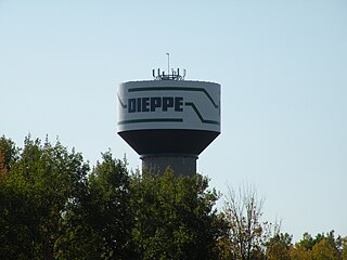
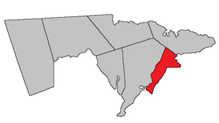
Dieppe is a city in the Canadian maritime province of New Brunswick. Statistics Canada counted the population at 28,114 in 2021, making it the fourth-largest city in the province. On 1 January 2023, Dieppe annexed parts of two neighbouring local service districts; revised census figures have not been released.

<span class="mw-page-title-main">Memramcook</span> Village in New Brunswick, Canada

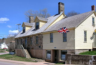
Memramcook, sometimes also spelled Memramcouke or Memramkouke, is a village in Westmorland County, New Brunswick, Canada. Located in south-eastern New Brunswick, the community is predominantly people of Acadian descent who speak the Chiac derivative of the French language. An agricultural village, it has a strong local patrimony, key to the history of the region. It was home to Mi'kmaqs for many years and was the arrival site of Acadians in 1700. A large part of these Acadians were deported in 1755, but the village itself survived.

<span class="mw-page-title-main">Petitcodiac River</span> River in south-eastern New Brunswick, Canada

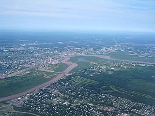
The Petitcodiac River is a river located in south-eastern New Brunswick, Canada. Local tourist businesses often refer to it as the "chocolate river" due to its distinctive brown mud floor and brown waters. Stretching across a meander length of 79 kilometres, the river traverses Westmorland, Albert, and Kings counties, draining a watershed area of about 2,071 square kilometres (800 sq mi). The watershed features valleys, ridges, and rolling hills, and is home to a diverse population of terrestrial and aquatic species. Ten named tributaries join the river in its course toward its mouth in Shepody Bay. Prior to the construction of a causeway in 1968, the Petitcodiac River had one of the world's largest tidal bores, which ranged from 1 to 2 metres (3.3–6.6 ft) in height and moved at speeds of 5 to 13 kilometres per hour (3.1–8.1 mph). With the opening of the causeway gates in April 2010, the river is flushing itself of ocean silts, and the bore is returning to its former size.

<span class="mw-page-title-main">Dorchester, New Brunswick</span> Place in New Brunswick, Canada

Dorchester is a community in Westmorland County, New Brunswick, Canada. The community became part of the new town of Tantramar in the 2023 New Brunswick local governance reform. Originally incorporated as a town in 1911, it was converted to a village in 1966. By 1825 it had been named for Guy Carleton, 1st Baron Dorchester, an 18th-century Governor-General of the old Province of Quebec, but prior to that was called Botsford.

<span class="mw-page-title-main">Moncton Parish, New Brunswick</span> Parish in New Brunswick, Canada

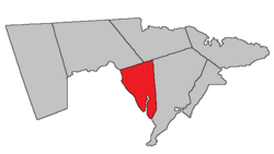
Moncton is a geographic parish in Westmorland County, New Brunswick, Canada.

<span class="mw-page-title-main">Kingsclear Parish, New Brunswick</span> Parish in New Brunswick, Canada

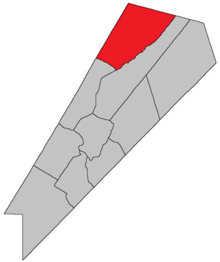
Kingsclear is a geographic parish in York County, New Brunswick, Canada.

<span class="mw-page-title-main">Coverdale Parish, New Brunswick</span> Parish in New Brunswick, Canada

Coverdale is a geographic parish in Albert County, New Brunswick, Canada, located along the Petitcodiac River opposite Moncton and Dieppe.

<span class="mw-page-title-main">Sackville Parish, New Brunswick</span> Parish in New Brunswick, Canada

Sackville is a geographic parish in Westmorland County, New Brunswick, Canada.

<span class="mw-page-title-main">Weldford Parish, New Brunswick</span> Parish in New Brunswick, Canada

Weldford is a geographic parish in Kent County, New Brunswick, Canada.

<span class="mw-page-title-main">Prince William Parish, New Brunswick</span> Parish in New Brunswick, Canada

Prince William is a geographic parish in York County, New Brunswick, Canada.

<span class="mw-page-title-main">Hillsborough Parish, New Brunswick</span> Parish in New Brunswick, Canada

Hillsborough is a geographic parish in eastern Albert County, New Brunswick, Canada.

<span class="mw-page-title-main">Hopewell Parish, New Brunswick</span> Parish in New Brunswick, Canada

Hopewell is a geographic parish in eastern Albert County, New Brunswick, Canada.

<span class="mw-page-title-main">Harvey Parish, New Brunswick</span> Parish in New Brunswick, Canada

Harvey is a geographic parish in southern Albert County, New Brunswick, Canada.

<span class="mw-page-title-main">Alma Parish, New Brunswick</span> Parish in New Brunswick, Canada

Alma is a geographic parish on the Bay of Fundy in the southwestern corner of Albert County, New Brunswick, Canada.

<span class="mw-page-title-main">Salisbury Parish, New Brunswick</span> Parish in New Brunswick, Canada

Salisbury is a geographic parish in Westmorland County, New Brunswick, Canada.

<span class="mw-page-title-main">Shediac Parish, New Brunswick</span> Parish in New Brunswick, Canada

Shediac is a geographic parish in Westmorland County, New Brunswick, Canada.

<span class="mw-page-title-main">Botsford Parish, New Brunswick</span> Parish in New Brunswick, Canada

Botsford is a geographic parish in Westmorland County, New Brunswick, Canada.

<span class="mw-page-title-main">Westmorland Parish, New Brunswick</span> Parish in New Brunswick, Canada

Westmorland is a geographic parish in Westmorland County, New Brunswick, Canada.

<span class="mw-page-title-main">Havelock Parish, New Brunswick</span> Parish in New Brunswick, Canada

Havelock is a geographic parish in Kings County, New Brunswick, Canada.

<span class="mw-page-title-main">Chipman Parish, New Brunswick</span> Parish in New Brunswick, Canada

Chipman is a geographic parish in Queens County, New Brunswick, Canada.

References

  1. 1 2 "Census Profile". Statistics Canada. 26 October 2022. Retrieved 29 October 2022.
  2. 1 2 3 "Chapter T-3 Territorial Division Act". Government of New Brunswick. Retrieved 26 March 2023.
  3. "Chapter I-13 Interpretation Act". Government of New Brunswick. Retrieved 26 March 2023.
  4. The Territorial Division Act [2] divides the province into 152 parishes, the cities of Saint John and Fredericton, and one town of Grand Falls. The Interpretation Act [3] clarifies that parishes include any local government within their borders.
  5. "Southeast Regional Service Commission: RSC 7". Government of New Brunswick. Retrieved 26 March 2023.
  6. "Southeast Regional Service Commission: RD 7". Government of New Brunswick. Retrieved 26 March 2023.
  7. "Regions Regulation – Regional Service Delivery Act". Government of New Brunswick. 21 July 2022. Retrieved 26 March 2023.
  8. "New Brunswick Regulation 85-6 under the Municipalities Act (O.C. 85-45)". Government of New Brunswick. Retrieved 23 July 2020.
  9. "Local Service Districts Regulation - Municipalities Act". Government of New Brunswick. 25 June 2021. Retrieved 26 March 2023.
  10. Ganong, William F. (1896). A Monograph of the Place-Nomenclature of the Province of New Brunswick. Royal Society of Canada. p. 230. Retrieved 17 March 2021.
  11. "27 Geo. III Chapter VII. An Act in Addition to an Act for the better ascertaining and confirming the Boundaries of the several Counties within this Province, and for Subdividing them into Towns or Parishes.". Acts of the General Assembly, of His Majesty's Province of New-Brunswick, Passed in the Year 1787. Saint John, New Brunswick: Government of New Brunswick. 1787. p. 147. Retrieved 27 March 2021.
  12. "8 Geo. IV c. 13 An Act to erect the North-eastern part of the County of Westmoreland into a distinct Town or Parish, and also to authorize the appointment of Parish Officers at the November General Sessions in each year.". Acts of the General Assembly of His Majesty's Province of New-Brunswick, Passed in the Year 1827. Fredericton: Government of New Brunswick. 1827. pp. 28–30. Retrieved 27 March 2021.
  13. "5 Wm. IV c. 15 An Act to alter the boundary line between certain Parishes in the County of Westmorland.". Acts of the General Assembly of His Majesty's Province of New-Brunswick, Passed in the Year 1835. Fredericton: Government of New Brunswick. 1835. p. 27. Retrieved 27 March 2021.
  14. 1 2 "57 Vic. c. 36 An Act to amend Chapter 2 of the Consolidated Statutes, of 'The division of the Province into Counties, Towns and Parishes,' so far as relates to the County of Westmorland.". Acts of the General Assembly of Her Majesty's Province of New Brunswick. Passed in the Month of April, 1894. Fredericton: Government of New Brunswick. 1894. pp. 162–163. Available as a free ebook from Google Books.
  15. 1 2 3 4 "No. 120". Provincial Archives of New Brunswick. Department of Natural Resources and Energy Development. Retrieved 24 June 2021. Remainder of parish on maps 132, 133, and 144 at same site.
  16. 1 2 3 4 "359" (PDF). Transportation and Infrastructure. Government of New Brunswick. Retrieved 24 June 2021. Remainder of parish on mapbooks 360, 380, 381, 400, and 401 at same site.
  17. 1 2 "Historical Magnetic Declination". National Oceanic and Atmospheric Administration. Retrieved 2 May 2021.
  18. "Chapter 227 Territorial Division Act". The Revised Statutes of New Brunswick 1952 Volume III. Fredericton: Government of New Brunswick. 1952. pp. 3725–3771.
  19. "13 Vic. c. 51 An Act to consolidate all the Laws now in force for the division of the Province into Counties, Towns and Parishes.". Acts of the General Assembly of Her Mjaesty's Province of New Brunswick, Passed in the Year 1850. Fredericton: Government of New Brunswick. 1850. pp. 142–152, 145–149. Book was poorly proofread, resulting in title typo and reuse of page numbers 145–152.
  20. 1 2 3 "Search the Canadian Geographical Names Database (CGNDB)". Government of Canada. Retrieved 3 July 2021.
  21. "Explore New Brunswick's Protected Natural Areas". GeoNB. Retrieved 3 July 2021.
  22. Statistics Canada: 2001, 2006 census
  23. 2011 Statistics Canada Census Profile: Dorchester Parish, New Brunswick
  24. 1 2 "Census Profile, 2016 Census: Dorchester, Parish [Census subdivision], New Brunswick". Statistics Canada. Retrieved 5 October 2019.
  25. Atlantic Canada Back Road Atlas ISBN   978-1-55368-618-7


46°01′25″N64°36′13″W / 46.023668°N 64.603729°W / 46.023668; -64.603729 (Dorchester Parish, New Brunswick)