
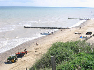
Cromer is a coastal town and civil parish on the north coast of the English county of Norfolk. It is 23 miles north of Norwich, 116 miles north-northeast of London and four miles east of Sheringham on the North Sea coastline. The local government authorities are North Norfolk District Council, whose headquarters is on Holt Road in the town, and Norfolk County Council, based in Norwich. The civil parish has an area of 4.66 km2 and at the 2011 census had a population of 7,683.

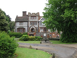
Overstrand is a village on the north coast of Norfolk in England, two miles east of Cromer. It was once a modest fishing station, with all or part of the fishing station being known as Beck Hythe. In the latter part of the 19th century it was catapulted into prominence, and became known as “the village of millionaires”.

Happisburgh is a village civil parish in the English county of Norfolk. The village is on the coast, to the east of a north–south road, the B1159 from Bacton on the coast to Stalham. It is a nucleated village. The nearest substantial town is North Walsham 6 miles (10 km) to the west.
Mundesley /ˈmʌn.dzli/ is a coastal village and a civil parish in the English county of Norfolk. The village is 20.3 miles (32.7 km) north-north east of Norwich, 7.3 miles (11.7 km) south east of Cromer and 136 miles (219 km) north east of London. The village lies 5.6 miles (9.0 km) north-north east of the town of North Walsham. The nearest railway station is at North Walsham, for the Bittern Line which runs between Sheringham and Norwich. The nearest airport is Norwich Airport. The village sits astride the B1159 coast road that links Cromer and Caister-on-Sea, and is at the eastern end of the B1145 a route which runs between King's Lynn and Mundesley. Mundesley is within the Norfolk Coast AONB. It has a resident population of around 2,695, measured at 2,758 in the 2011 Census. The River Mun or Mundesley Beck flows into the sea here. On 5 September 2022 Mundesley beach won the North Norfolk District Council Battle of the Beaches to be recognised as the top beach in North Norfolk in a close run off against West Runton beach.

East Beckham is a village and a civil parish in the English county of Norfolk. The village is 23.4 miles (37.7 km) north of Norwich, 5 miles (8 km) south-west of Cromer and 137 miles (220 km) north-east of London. The nearest railway station is in the town of Sheringham, where access to the national rail network can be made via the Bittern Line to Norwich. The nearest Airport is Norwich International Airport. East Beckham is within the area covered by North Norfolk District Council. At the 2011 Census the population was less than 100 and is included with civil parish of West Beckham.

Lynford Hall is a neo-Jacobean country house at Mundford, near Thetford in the English county of Norfolk. It is now a hotel.

Matlaske is a village and a civil parish in the English county of Norfolk. The village is 21.6 miles (34.8 km) North-north-west of Norwich, 9.3 miles (15.0 km) south-west of Cromer and 136 miles (219 km) north-north-east of London. The nearest railway station is at Sheringham for the Bittern Line which runs between Sheringham, Cromer and Norwich. The nearest airport is Norwich International Airport. The parish of Matlask in the 2001 census, a population of 124, increasing to 139 at the 2011 Census. For the purposes of local government, the parish falls within the district of North Norfolk.

Wickmere is a village and a civil parish in the English county of Norfolk, 18.9 miles (30.4 km) north of Norwich, 7.3 miles (11.7 km) south-southwest of Cromer and 132 miles (212 km) northeast of London. The nearest railway station is at Gunton for the Bittern Line which runs between Sheringham, Cromer and Norwich. The nearest airport is Norwich International Airport. In the 2001 census it had a population of 125, which increased to 158 at the 2011 census. For the purposes of local government, the it falls within the district of North Norfolk.

Sidestrand is a village and a civil parish on the coast of the English county of Norfolk. The village is 23.7 mi (38.1 km) north of Norwich, 3.3 mi (5.3 km) south east of Cromer and 138 mi (222 km) north-east of London. The nearest railway station is at North Walsham for the Bittern Line which runs between Cromer and Norwich. The nearest airport is Norwich International Airport. From the Census 2011 the population was included in the civil parish of Trimingham.
Southrepps is a village and a civil parish in the English county of Norfolk. The village is 5.2 miles (8.4 km) southeast of Cromer, 21.9 miles (35.2 km) north of Norwich and 136.0 miles (218.9 km) north of London. The village lies northeast of the A149 between Kings Lynn and Great Yarmouth. The nearest railway station is at Gunton for the Bittern Line which runs between Sheringham, Cromer and Norwich. The nearest airport is Norwich International Airport. The village is close to the sea and surrounded by rich agricultural land.

Sprowston Manor Hotel is a AA 4 star hotel, part of which is the 19th-century Sprowston Hall. It is located on the north east suburbs, of the English city of Norwich, close to the suburb of Sprowston and village of Rackheath, within the county of Norfolk, United Kingdom.

The B1159 is a road in Norfolk, England, running for about 32 miles (51 km) between Cromer and Caister-on-Sea, parallel to and at a short distance from the northeastern coast of Norfolk.
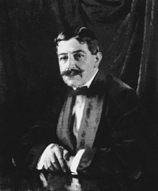
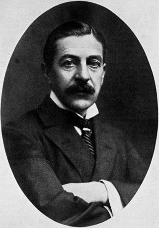
Sir Edgar Speyer, 1st Baronet was an American-born financier and philanthropist. He became a British subject in 1892 and was chairman of Speyer Brothers, the British branch of the Speyer family's international finance house, and a partner in the German and American branches. He was chairman of the Underground Electric Railways Company of London from 1906 to 1915, a period during which the company opened three underground railway lines, electrified a fourth and took over two more.

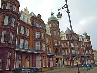
The Cliftonville Hotel is an AA 3 star Hotel, and Grade II listed building, located in the English seaside town of Cromer in the county of Norfolk, United Kingdom.
The Hotel de Paris is a hotel in the English seaside town of Cromer in the county of Norfolk, United Kingdom. It has an AA three-star rating.

The Red Lion Hotel is an AA 4 star hotel located in the English seaside town of Cromer in the county of Norfolk, United Kingdom.

The Sandcliff Hotel is an AA 3 star hotel located on the seafront in the English town of Cromer, within the county of Norfolk, United Kingdom.

The Bell Hotel is an AA 3-star hotel in the English town of Thetford within the county of Norfolk. The hotel has been a Grade II* listed building since 3 April 1951.
The Dales Country House Hotel is a grade II listed building which is in the English coastal village of Upper Sheringham in the county of Norfolk, United Kingdom. The hotel is also an AA 4-star hotel. The hotel also has 2 AA Rosettes for Food.
The Speyer family is a prominent Jewish family of German descent. It can be traced back to Michael Isaac Speyer (1644–1692), who had briefly been the head of the Jewish community in Frankfurt am Main in 1691–92. The family originates from Speyer in Palatinate, hence the surname. In the late eighteenth century, the Speyers were the wealthiest Jewish family in Frankfurt, well above the Rothschild family.

