
The Gask Ridge is the modern name given to an early series of fortifications, built by the Romans in Scotland, close to the Highland Line. Modern excavation and interpretation has been pioneered by the Roman Gask Project, with Birgitta Hoffmann and David Woolliscroft. The ridge fortifications: forts, fortlets and watchtowers were only in operation for a few years, probably less than ten.

Summerston is a residential area of Glasgow, Scotland. With most of the housing constructed in the 1970s, it is situated in the far north of the city and is considered to be part of the larger Maryhill district, but has a different postcode; other nearby neighbourhoods are Gilshochill to the south and Cadder to the south-east. With open farmland to the north-east, Summerston is separated from the southern parts of the town of Bearsden to the north-west by the River Kelvin and a golf course.

Duntocher is a village in West Dunbartonshire, Scotland. It has an estimated population of 6,850. The etymology of the name of the village indicates that its name means "the fort on the causeway".

Cadder is a district of the town of Bishopbriggs, East Dunbartonshire, Scotland. It is located 7 km north of Glasgow city centre, 0.5 km south of the River Kelvin, and approximately 1.5 km north-east of Bishopbriggs town centre, sited on the route of the Forth and Clyde Canal. There is a Glasgow council housing scheme of a similar name, generally pronounced Cawder, in the district of Lambhill some 3 miles (5 km) to the south-west along the Canal, which was built in the early 1950s. Similarly, within Cadder, there is Cawder Golf Club, which also uses that original pronunciation.
Croy is a village in North Lanarkshire, Scotland. A former mining community, Croy is situated south of Kilsyth and north of Cumbernauld, some 13 miles (21 km) from Glasgow and 37 miles (60 km) from Edinburgh on the main railway line between the two cities. Croy has a population of about 1,390.

Rough Castle Fort is a Roman fort on the Antonine Wall roughly 2 kilometres south east of Bonnybridge near Tamfourhill in the Falkirk council area, Scotland. It is owned by the National Trust for Scotland.

Castlecary is a small historic village in North Lanarkshire, Scotland, directly adjacent to the border with Falkirk. It has long been associated with infrastructure, being adjacent to a bridged river, a Roman fort and roads, a nationwide canal, a Victorian railway viaduct, and a modern motorway. Castlecary is close to the town of Cumbernauld but like Dullatur and Luggiebank is not officially part of the town. Around 1725, the barony of Castlecary, with a population of just seventeen families, was disjoined from the parish of Falkirk, and annexed to Cumbernauld quoad sacra. Castlecary is also near Allandale which, though in the Falkirk council area, was built for Castlecary fireclay workers.

Westerwood is an area in the north-east of Cumbernauld in North Lanarkshire, Scotland. Historically it was the site of a Roman Fort of which a video reconstruction has been produced. In the past two decades, new housing developments have been built around the Westerwood Hotel and Golf Course. The golf course, which was designed by Seve Ballesteros and Dave Thomas, is located on the north side of the town, close to Cumbernauld Airport. Westerwood Community Council was set up for local residents and a committee has been appointed. Neighbouring villages which are outside of Cumbernauld include Dullatur to the north-west and Castlecary to the east.

The Antonine Wall, known to the Romans as Vallum Antonini, was a turf fortification on stone foundations, built by the Romans across what is now the Central Belt of Scotland, between the Firth of Clyde and the Firth of Forth. Built some twenty years after Hadrian's Wall to the south, and intended to supersede it, while it was garrisoned it was the northernmost frontier barrier of the Roman Empire. It spanned approximately 63 kilometres and was about 3 metres high and 5 metres wide. Lidar scans have been carried out to establish the length of the wall and the Roman distance units used. Security was bolstered by a deep ditch on the northern side. It is thought that there was a wooden palisade on top of the turf. The barrier was the second of two "great walls" created by the Romans in Great Britain in the second century AD. Its ruins are less evident than those of the better-known and longer Hadrian's Wall to the south, primarily because the turf and wood wall has largely weathered away, unlike its stone-built southern predecessor.

Bar Hill Fort was a Roman fort on the Antonine Wall in Scotland. It was built around the year 142 A.D.. Older maps and documents sometimes spell the name as Barr Hill. A computer generated fly around for the site has been produced. Lidar scans have been done along the length of the wall including Bar Hill. Sir George Macdonald wrote about the excavation of the site. Many other artefacts have also been found at Shirva, about a mile away on the other side of Twechar.
Croy Hill was a Roman fort, fortlet, and probable temporary camp on the Antonine Wall, near Croy, to the north east of the village in Scotland. Two communication platforms known as ‘expansions’ can be seen to the west of the fortlet. Alexander Park excavated the site in 1890-1891. Sir George Macdonald wrote about his excavation of the site which occurred in 1920, 1931, and 1935. At Croy Hill, the ditch in front of the rampart was not excavated by the Romans. It is likely that hard basalt and dolerite of the hill was virtually impossible to shape with Roman tools. This is the only place along the Wall where the ditch wasn't dug. There is a bath house just outside one fort. A video reconstruction of the site has been produced.

Auchendavy was a Roman fort on the Antonine Wall in Scotland. Much of the site archeology was destroyed by the builders of the Forth and Clyde Canal. Between Bar Hill and Balmuildy the wall roughly follows the southern bank of the River Kelvin. The site of the fort is north of Kirkintilloch's northern border. It can be seen as a mound mid-way between the Forth and Clyde Canal and the road.

Glasgow Bridge is the site of a road bridge over the Forth and Clyde Canal; it is also the site of a Roman fortlet, on the Antonine Wall, halfway between the Roman forts at Kirkintilloch and Cadder.

Cleddans is the site of a Roman fortlet on the Antonine Wall in Scotland. Its postulated existence was confirmed by trial trenching in 1979. Evidence of building work on Cleddans and on the Wall by units of both the sixth and the twentieth legions has been found in the area.

Watling Lodge was a Roman fortlet on the Antonine Wall in Scotland. It was located near what is now Lock Sixteen on the Forth and Clyde Canal in Falkirk with neighbouring forts at Rough Castle to the west and Falkirk to the east. There was also a fort at Camelon to the north. There was also a Roman temporary camp found a short distance south of the site.

Mumrills was the site of the largest Roman fort on the Antonine Wall in Scotland. It is possible that Mumrills could exchange signals with Flavian Gask Ridge forts. Some believe Mumrills may have been the site of Wallace's defeat at the Battle of Falkirk. The farm at Mumrills was also used as an early site for the Falkirk Relief Church.

Inveravon is sited on the east side of the River Avon in Scotland. It was long considered to be the likely site for a Roman Fort on the Antonine Wall in Scotland. The fort is one of the most dubious on the wall although some excavation and geophysics has been done. Near Inveravon Tower, the bare traces of a fort were found but there is nothing that an unskilled visitor could identify. Several excavations have unearthed the site's foundations as well as a section of the Military Way. Cobbled surfaces and some stone walls were found. Also ‘expansions’ were discovered, perhaps used as signal or beacon towers.

Castlehill was a Roman fort on the Antonine Wall in Scotland.

Balmuildy is the site of a Roman fort on the Antonine Wall in Scotland. It is one of only two forts on the Antonine Wall to have been found with stone ramparts; the other is Castlecary. A digital reconstruction of the fort has been created.

Wilderness Plantation was the site of a Roman fortlet on the Antonine Wall in Scotland.
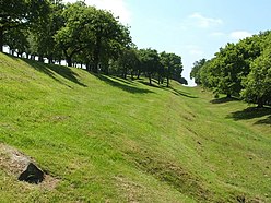


 The Wall, The Road and The Forth and Clyde Canal at Seabegs Wood [12]
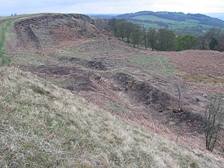
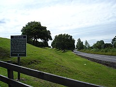 Seabegs Wood and the Antonine Wall between Bonnybridge and Allandale
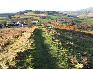
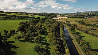 Antonine Wall West of Bonnybridge


