Watling Lodge

Last updated

Watling Lodge
Antonine Wall at Watling Lodge (geograph 3175254).jpg
Scotland centre location map.svg
Red pog.svg
Location within Scotland Central Belt
Founded during the reign of Antoninus Pius
Founded142 AD
Place in the Roman world
Province Britannia
Structure
— Turf structure —
Location
Coordinates Coordinates: 55°59′51″N3°49′31″W / 55.9976°N 3.8253°W / 55.9976; -3.8253
TownNear Tamfourhill
County Falkirk
Country Scotland
Site notes
ConditionRuined

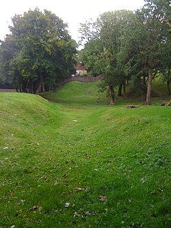
Watling Lodge was a Roman fortlet on the Antonine Wall in Scotland. [1] It was located near what is now Lock Sixteen on the Forth and Clyde Canal in Falkirk with neighbouring forts at Rough Castle to the west and Falkirk to the east. [2] There was also a fort at Camelon to the north. There was also a Roman temporary camp found a short distance south of the site. [3]

Contents

Description

Watling Lodge has been described as the best preserved stretch of ditch from the Antonine Wall still in existence today. [4] It is situated along Tamfourhill Road, south-west of Falkirk. [5] This stretch is excellently preserved. [6] One of the best overviews of the site is the video of the Bridgeness Slab by Falkirk Council, [7] presented by Geoff Bailey, Keeper of Archeology and Local History at Falkirk Museum, from about 4 minutes 30s.

In Falkirk, the site is signposted from the A9 and is accessed from the B816, Tamfourhill Road. [8] There is an information panel fairly close to the top of the wall. [9] The panel shows how the Wall may have looked, and suggests Watling Lodge's place in the grand design of the construction. [10]

Excavation and finds

Sir George Macdonald wrote about the site. [11] A digital reconstruction of the fortlet has been created. [12] A Minecraft model of the site has also been constructed. [13]

Many Roman forts along the wall held garrisons of around 500 men. [14] Larger forts like Castlecary and Birrens had a nominal cohort of 1000 men [15] but probably sheltered women and children [16] as well, although the troops were not allowed to marry. [17] It is likely that large communities of civilians were located around the site. [18]

Antonine's Wall at Watling Lodge - geograph.org.uk - 1140335.jpg
Antonine's Wall at Watling Lodge near Falkirk
Ditch of the Antonine Wall at Watling Lodge (geograph 1649848).jpg
Ditch of the Antonine Wall at Watling Lodge
Forts and Fortlets associated with the Antonine Wall from west to east: Bishopton, Old Kilpatrick, Duntocher, Cleddans, Castlehill, Bearsden, Summerston, Balmuildy, Wilderness Plantation, Cadder, Glasgow Bridge, Kirkintilloch, Auchendavy, Bar Hill, Croy Hill, Westerwood, Castlecary, Seabegs, Rough Castle, Camelon, Watling Lodge, Falkirk, Mumrills, Inveravon, Kinneil, Carriden Antonine.Wall.Roman.forts.jpg
Forts and Fortlets associated with the Antonine Wall from west to east: Bishopton, Old Kilpatrick, Duntocher, Cleddans , Castlehill, Bearsden, Summerston , Balmuildy, Wilderness Plantation , Cadder, Glasgow Bridge , Kirkintilloch, Auchendavy, Bar Hill, Croy Hill, Westerwood, Castlecary, Seabegs , Rough Castle, Camelon, Watling Lodge, Falkirk, Mumrills, Inveravon, Kinneil , Carriden

Related Research Articles

Summerston Human settlement in Scotland

Summerston is a residential area of Glasgow, Scotland. With most of the housing constructed in the 1970s, it is situated in the far north of the city and is considered to be part of the larger Maryhill district, but has a different postcode; other nearby neighbourhoods are Gilshochill to the south and Cadder to the south-east. With open farmland to the north-east, Summerston is separated from the southern parts of the town of Bearsden to the north-west by the River Kelvin and a golf course.

Duntocher Human settlement in Scotland

Duntocher is a village in West Dunbartonshire, Scotland. It has an estimated population of 6,850. The etymology of the name of the village indicates that its name means "the fort on the causeway".

Cadder Human settlement in Scotland

Cadder Not to be confused with the Glasgow area of a similar name, is a district of the town of Bishopbriggs, East Dunbartonshire, Scotland. It is located 7 km north of Glasgow city centre, 0.5 km south of the River Kelvin, and approximately 1.5 km north-east of Bishopbriggs town centre, sited on the route of the Forth and Clyde Canal. There is a Glasgow council housing scheme of a similar name, generally pronounced Cawder, in the district of Lambhill some 3 miles (5 km) to the south-west along the Canal, which was built in the early 1950s. Similarly, within Cadder, there is Cawder Golf Club, which also uses that original pronunciation.

Rough Castle Fort

Rough Castle Fort is a Roman fort on the Antonine Wall roughly 2 kilometres south east of Bonnybridge near Tamfourhill in the Falkirk council area, Scotland. It is owned by the National Trust for Scotland.

Castlecary Human settlement in Scotland

Castlecary is a small historic village in North Lanarkshire, Scotland, directly adjacent to the border with Falkirk. It has long been associated with infrastructure, being adjacent to a bridged river, a Roman fort and roads, a nationwide canal, a Victorian railway viaduct, and a modern motorway. Castlecary is close to the town of Cumbernauld but like Dullatur and Luggiebank is not officially part of the town. Around 1725, the barony of Castlecary, with a population of just seventeen families, was disjoined from the parish of Falkirk, and annexed to Cumbernauld quoad sacra. Castlecary is also near Allandale which, though in the Falkirk council area, was built for Castlecary fireclay workers.

Westerwood

Westerwood is an area in the north-east of Cumbernauld in North Lanarkshire, Scotland. Historically it was the site of a Roman Fort of which a video reconstruction has been produced. In the past two decades, new housing developments have been built around the Westerwood Hotel and Golf Course. The golf course, which was designed by Seve Ballesteros and Dave Thomas, is located on the north side of the town, close to Cumbernauld Airport. Westerwood Community Council was set up for local residents and a committee has been appointed. Neighbouring villages which are outside of Cumbernauld include Dullatur to the north-west and Castlecary to the east.

Antonine Wall Defensive fortification in Roman Britain

The Antonine Wall, known to the Romans as Vallum Antonini, was a turf fortification on stone foundations, built by the Romans across what is now the Central Belt of Scotland, between the Firth of Forth and the Firth of Clyde. Built some twenty years after Hadrian's Wall to the south, and intended to supersede it, while it was garrisoned it was the northernmost frontier barrier of the Roman Empire. It spanned approximately 63 kilometres and was about 3 metres high and 5 metres wide. Lidar scans have been carried out to establish the length of the wall and the Roman distance units used. Security was bolstered by a deep ditch on the northern side. It is thought that there was a wooden palisade on top of the turf. The barrier was the second of two "great walls" created by the Romans in Great Britain in the second century AD. Its ruins are less evident than those of the better-known and longer Hadrian's Wall to the south, primarily because the turf and wood wall has largely weathered away, unlike its stone-built southern predecessor.

Arthurs Oon Probable Roman temple near Falkirk, Scotland, destroyed in 1743

Arthur's O'on was a stone building thought to be Roman temple that, until 1743, stood on rising ground above the north bank of the River Carron not far from the old Carron ironworks in Stenhousemuir, near Falkirk, Scotland. The structure is thought to be the 'stone house' which gave its name to Stenhousemuir. Early historians discussed historical and mythical associations with the site and by 1200 the estate of Stenhouse on which it stood had been named after it.

Carriden House

Carriden House is a 14,041 square feet (1,304.5 m2) mansion in the parish of Bo'ness and Carriden, in the Falkirk council area, east central Scotland. It is located on the Antonine Wall 2.5 kilometres (1.6 mi) east of Bo'ness, and 4 kilometres (2.5 mi) north-east of Linlithgow, in the former county of West Lothian. The earliest part of the house is an early 17th-century tower house, which was extended in the 17th and 19th centuries. Carriden House is protected as a category A listed building.

Bar Hill Fort

Bar Hill Fort was a Roman fort on the Antonine Wall in Scotland. It was built around the year 142 A.D.. Older maps and documents sometimes spell the name as Barr Hill. A computer generated fly around for the site has been produced. Lidar scans have been done along the length of the wall including Bar Hill. Sir George Macdonald wrote about the excavation of the site. Many other artefacts have also been found at Shirva, about a mile away on the other side of Twechar.

Croy Hill

Croy Hill was a Roman fort, fortlet, and probable temporary camp on the Antonine Wall, near Croy, to the north east of the village in Scotland. Two communication platforms known as ‘expansions’ can be seen to the west of the fortlet. Alexander Park excavated the site in 1890-1891. Sir George Macdonald wrote about his excavation of the site which occurred in 1920, 1931, and 1935. At Croy Hill, the ditch in front of the rampart was not excavated by the Romans. It is likely that hard basalt and dolerite of the hill was virtually impossible to shape with Roman tools. This is the only place along the Wall where the ditch wasn't dug. There is a bath house just outside one fort. A video reconstruction of the site has been produced.

Auchendavy

Auchendavy was a Roman fort on the Antonine Wall in Scotland. Much of the site archeology was destroyed by the builders of the Forth and Clyde Canal. Between Bar Hill and Balmuildy the wall roughly follows the southern bank of the River Kelvin. The site of the fort is north of Kirkintilloch's northern border. It can be seen as a mound mid-way between the Forth and Clyde Canal and the road.

Glasgow Bridge, Kirkintilloch

Glasgow Bridge is the site of a road bridge over the Forth and Clyde Canal; it is also the site of a Roman fortlet, on the Antonine Wall, half way between the Roman forts at Kirkintilloch and Cadder.

Cleddans Roman fortlet on the Antonine Wall, Scotland

Cleddans is the site of a Roman fortlet on the Antonine Wall in Scotland. Its postulated existence was confirmed by trial trenching in 1979. Evidence of building work on Cleddans and on the Wall by units of both the sixth and the twentieth legions has been found in the area.

Mumrills

Mumrills was the site of the largest Roman fort on the Antonine Wall in Scotland. It is possible that Mumrills could exchange signals with Flavian Gask Ridge forts. Some believe Mumrills may have been the site of Wallace's defeat at the Battle of Falkirk. The farm at Mumrills was also used as an early site for the Falkirk Relief Church.

Inveravon

Inveravon is sited on the east side of the River Avon in Scotland. It was long considered to be the likely site for a Roman Fort on the Antonine Wall in Scotland. The fort is one of the most dubious on the wall although some excavation and geophysics has been done. Near Inveravon Tower, the bare traces of a fort were found but there is nothing that an unskilled visitor could identify. Several excavations have unearthed the site's foundations as well as a section of the Military Way. Cobbled surfaces and some stone walls were found. Also ‘expansions’ were discovered, perhaps used as signal or beacon towers.

Seabegs Wood Site of a Roman fortlet on the Antonine Wall in Scotland

Seabegs Wood was the site of a Roman fortlet on the Antonine Wall in Scotland.

Castlehill Fort

Castlehill was a Roman fort on the Antonine Wall in Scotland.

Balmuildy

Balmuildy is the site of a Roman fort on the Antonine Wall in Scotland. It is one of only two forts on the Antonine Wall to have been found with stone ramparts; the other is Castlecary. A digital reconstruction of the fort has been created.

Wilderness Plantation Site of Roman fortler

Wilderness Plantation was the site of a Roman fortlet on the Antonine Wall in Scotland.

References

  1. "Watling Lodge". CANMORE . Royal Commission on the Ancient and Historical Monuments of Scotland . Retrieved 14 November 2017.
  2. "OS 25 inch map 1892-1949, with Bing opacity slider". National Library of Scotland. Ordnance Survey. Retrieved 12 October 2017.
  3. "TAMFOURHILL AND WATLING LODGE: SECTION OF DITCH AND FORTLET" (PDF). Frontiers of the Roman Empire. Retrieved 19 May 2018.
  4. "Antonine Wall World Heritage Site". visitscotland. Retrieved 17 November 2017.
  5. "Barnardo's". The Falkirk Herald. Retrieved 17 November 2017.
  6. "Watling Lodge Antonine Wall Fortlet & Camp". Roman Britain. Retrieved 17 November 2017.
  7. "Roman film now online". Kinneil Estate, Bo'ness. Retrieved 22 October 2017.
  8. "Watling Lodge". Frontiers of the Roman Empire. Retrieved 17 November 2017.
  9. ""Antonine Roman Wall (Watling Lodge section)"". TripAdvisor. Retrieved 17 November 2017.
  10. Ross, David. "Watling Lodge (Antonine Wall)". Britain Express. Retrieved 17 November 2017.
  11. Macdonald, Sir George (1934). The Roman wall in Scotland, by Sir George Macdonald (2d ed., rev., enl., and in great part rewritten ed.). Oxford: The Clarendon press. pp. 127–128. Retrieved 11 October 2017.
  12. "Reconstruction of fortlet, Watling Lodge" . Retrieved 19 May 2018.
  13. "Watling Lodge". Dig It! 2017. Retrieved 17 November 2017.
  14. "Soldier". Frontiers of the Roman Empire. Retrieved 21 October 2017.
  15. Miller, S. N. (1952). The Roman Occupation Of South Western Scotland Being Reports Of Excavations And Surveys Carried Out Under The Auspices Of The Glasgow Archaeological Society By John Clarke, J. M. Davidson, Anne S. Robertson, J. K. St. Joseph, Edited For The Society With An Historical Survey By S. N. Miller. Glasgow: Robert Maclehose & Company Limited. Retrieved 11 October 2017.
  16. "Children". Frontiers of the Roman Empire. Retrieved 21 October 2017.
  17. "Roman child's leather shoe". A History of the World. BBC. Retrieved 17 October 2017.
  18. Rohl, Darrell, Jesse. "More than a Roman Monument: A Place-centred Approach to the Long-term History and Archaeology of the Antonine Wall" (PDF). Durham Theses. Durham University. Available at Durham E-Theses Online ref: 9458. Retrieved 14 October 2017.