Bajura District, a part of Sudurpashchim Province, is one of the seventy-seven districts of Nepal. The district, with Martadi as its district headquarters, covers an area of 2,188 km2 (845 sq mi) and had a population of 108,781 in 2001 and 134,912 in 2011.
Dadeldhura, a part of Sudurpashchim Province, is one of the seventy-seven districts of Nepal. The district, with Dadeldhura as its district headquarters, covers an area of 1,538 km2 (594 sq mi) and had a population of 126,162 in 2001 and 142,094 in 2011.

Myagdi District, a part of Gandaki Province, is one of the seventy-seven districts of Nepal. The district, with Beni as its district headquarters, covers an area of 2,297 km2 (887 sq mi), had a population of 114,447 in 2001 and 113,641 in 2011.
Rajapur is a municipality in Bardiya District in Lumbini Province of south-western Nepal. The municipality was established on 18 May 2014 merging the existing Daulatpur, Naya Gaun, Badalpur, Bhimapur, Manpur Tapara and Rajapur village development committees (VDCs). It is located on the border with Uttar Pradesh state, India. It has a customs checkpoint for goods. Indian and Nepalese nationals may cross the border without restriction.
Chulachuli is a rural municipality (gaunpalika) out of six rural municipality located in Ilam District of Koshi Province of Nepal. There are a total of 10 municipalities in Ilam in which 4 are urban and 6 are rural.
Shantinagar is a town and a Rural municipality in Dang District in Lumbini Province of south-western Nepal. At the time of the 1991 Nepal census it had a population of 8,854.
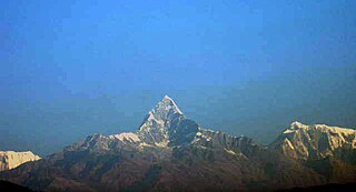
Machhapuchchhre is a Gaunpalika and former village development committee in Kaski District in the Gandaki Province of northern-central Nepal. At the time of the 1991 Nepal census it had a population of 1,881 persons living in 378 individual households.
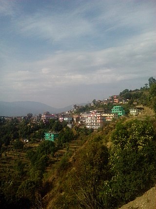
Dullu is an urban Municipality in Dailekh District of Karnali Province in Nepal.
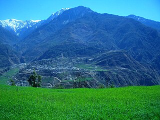
Baranja is a village development committee in Myagdi District in the Dhaulagiri Zone of western-central Nepal. At the time of the 1991 Nepal census it had a population of 4576 people living in 891 individual households.
Mohanyal is a former village development committee that is now a rural municipality in Kailali District in Sudurpashchim Province of western Nepal. At the time of the 1991 Nepal census it had a population of 3917 living in 614 individual households.
Bigu is a former village development committee that is now a ward-7 rural municipality in Dolakha District in Bagmati Province of northeastern Nepal. At the 1991 Nepal census, Bigu had a population of 1,736 people living in 361 individual households.
Melung is a Rural municipality located within the Dolakha District of the Bagmati Province of Nepal. The municipality spans 86.54 square kilometres (33.41 sq mi) of area, with a total population of 20,210 according to a 2011 Nepal census.

Manthali is a municipality and the headquarters of Ramechhap District in Bagmati Province, Nepal that was established on 2 December 2014 by merging the former village development committees Old-Manthali, Bhatauli, Chisapani, Kathjor, Bhaluwajor, Salupati and Sunarpani. It was declared the headquarters of the district on 9 March 1989. It lies on the bank of the Tamakoshi River. At the time of the 2011 Nepal census, it had a population of 45,416 people, living in 10,099 individual households.

Hariharpur Gadhi is a Gaunpalika and former village development committee in Sindhuli District in Bagmati Province of central Nepal. At the time of the 1991 Nepal census it had a population of 3,113 people living in 437 individual households.
Triveni is a rural municipality in Salyan District in the Karnali Province of western-central Nepal. At the time of the 1991 Nepal census it had a population of 3789 people living in 710 individual households.
Chainpur is a municipality in Sankhuwasabha District in the Koshi Province of north-eastern Nepal. It was formed by merging five villages i.e. Chainpur, Siddhakali, Siddhapokhari, Baneshwar and Kharang. The municipality was implemented on 18 May 2014. At the time of the 1991 Nepal census it had a population of 4933 people in 948 households.
Belauri, The former village development committee was converted into municipality, merging with existing Rampur Bilaspur, Laxmipur and Sreepur village development committee on 18 May 2014. At the time of the 1991 Nepal census it had a population of 14,280 people living in 1877 individual households.
Manahari is a Rural Municipality in Makwanpur District in the Bagmati Province of Nepal. At the time of the 1991 Nepal census it had a population of 10,013 people living in 1789 individual households.
Raksirang is a rural municipality in Makwanpur District in the Bagmati Province of Nepal. At the time of the 1991 Nepal census, Raksirang village development committee had a population of 6343.

Kalinchowk is a Rural municipality located within the Dolakha district of the Bagmati province of Nepal. The municipality spans 132.49 square kilometres (51.15 sq mi) of area, with a total population of 22,954 according to a 2011 Nepal census.

