Melamchi

Last updated
Melamchi Municipality
मेलम्ची नगरपालिका
Melamchi
Town
Nepal Bagmati adm location map.svg
Red pog.svg
Melamchi Municipality
Location in province
Nepal adm location map.svg
Red pog.svg
Melamchi Municipality
Melamchi Municipality (Nepal)
Coordinates: 27°50′N85°34′E / 27.83°N 85.56°E / 27.83; 85.56
CountryFlag of Nepal.svg    Nepal
Province Bagmati Province
District Sindhupalchok District
Established16 December 2014
Government
  Type Mayor-council
   Mayor Aaitman Tamang
   Deputy Mayor Uma pradhan
Population
 (2013)
  Total45,343
  Religions
Buddhism Hinduism
Time zone UTC+5:45 (NST)
Website www.melamchimun.gov.np

Melamchi is a municipality in Sindhupalchok District in the Bagmati Province of central Nepal. At the time of the 1991 Nepal census it had a population of 3936 and had 710 houses in the village. [1]

Contents

Government of Nepal has initiated a drinking water project called Melamchi water supply project to Kathmandu Valley.

The Melamchi Valley is typically narrow, steep Himalayan River-Valley. The lower valley slopes are very steep, rocky and V-shaped in the High Mountain whereas in the Middle the valley slopes are dissected by rolling alluvial tars at the bottom. The middle mountain slopes, have gentler aspect and are the sites of settlements. The upper mountain slopes are very steep, rocky and with pointed ridgeline. On the contrary, upper hill slopes of middle part are also often rounded and smooth and are exploited for mountain agriculture and settlement. Elevation differences between the valley floor and surrounding ridges exceed over 1,000 m in the upper part.

People

The total population of the Melamchi Valley is 68,800 and the household size is 5.2 in average. Around 50.7 percent of the population is male and 49.3 percent of the population is female. About 40.5 percent of the population is under 14 years of age and 52 percent are under 60 years of age. Around 36 percent of the populations are Brahmin, Chhetri and Newar. Tamangs represent 38 percent and 6 percent are Kamis, Damais and Sarkis (KDS) and rest are others. Around 48.7 percent of the total population is economically active.

Culture

Hindu culture dominates the settlements of the valley areas while the Buddhist culture is prevalent in the high mountain settlements. Mid-hill settlements of the valley is the meeting ground of the two cultures. There are more than 11 Hindu temples and shrines, and about 14 monasteries in the Melamchi watershed.

Climate

The lower part of Melamchi valley has Sub-Tropical climate, while the upper part has Cool Temperate climate. Upper part Melamchi valley receives more rainfall than in the lower part. Heavy rainfall occurs in June, July and August. Rainfall in January and February is the lowest. The annual average rainfall in the Melamchi basin is about 2800 mm which is concentrated mostly during four months of the monsoon of mid-June to mid-September. Average annual rainfall conditions vary considerably by location in the valley. In general, average annual rainfall is low at lower elevation and is relatively high in the higher elevation. The average annual rainfall recorded for the period of 1991 to 1996 is 3,410 mm.

Institutions, NGOs and CBOs

There are various government programs conducted through DDCs and VDCs. There are about 38 NGOs and CBOs working the valley. They are working in the field of Health, Environment, Public awareness, Poverty Alleviation and Women development along with youth mobilization. Local Governance Program (LGP), sponsored by UNDP, and Action Aid Nepal (AAN) are working in the field of community development in the valley. Economy

The per capita income is Rs 6571. Melamchi Valley produces 17,883 metric tons of paddy, while requirement of food grain is lonely 11,027 metric tons per year. About 94 percent of the economically active populations are engaged in farm activities. Most of them are self-employed (over 80%). The major income activities in Melamchi area are services, pottering, business, tourism and remittances. Operation of water mills and fishing are also the major off-farm activities. Fishing is another source of income generating actively for the economically disadvantaged groups of the area. Disadvantaged group includes particularly Majhi, Danuwar, Tamang and Damai & Kami.

Tourism

Tourism sector is very significant to Melamchi area considering its diverse tradition and culture. The number of people directly benefited by tourism is not known. However, many people benefit directly or indirectly by tourism. Places like Helambu, Nakote, Melamchi Ghyang and Tarke Ghyang are most attractive places for tourism. According to Nepal Tourism Board, in average, 7,600 to 9,600 trekking permits are issued to the tourists who visit upstream areas of the Melamchi and to the Langtang National Park.

Health

Over 60 percent of households have access to safe water within 10 minutes’ travel time. Only 25 percent households have their own latrines. About 60 percent of the households have garbage pits to dispose household wastes. There is no water based sewer system in the Melamchi Valley. Stomach disorders (Diarrhea, Dysentery), and Respiratory problems (colds, coughs, Pneumonia, Asthma, Bronchitis, etc.) are the major diseases in Melamchi Valley. In addition, there are cases of TB, Leprosy, Malaria, STDs and some reported cases of HIV/AIDS in the valley. There are altogether 11 health centre within the Melamchi Valley. The nearest hospitals are located in Chautara, Sindhupalchok district and in Banepa (Kavrepalanchok district). An Ayurvedic dispensary is located at Melamchi Bazaar provides outdoor services through Ayurvedic physician. An ambulance has been provided by the MWSP for services in the valley. The service is provided by the Nepal Red Cross.

Environment

River system: The Melamchi River, a tributary of larger Indrawati River basin, originates from the high snowy mountain of the Jugal Himal at an elevation of 5875m. It joins with Indrawati River at Melamchi Pul Bazaar. The length of river is 41 km and the catchments area at the Melamchi Pul Bazaar, is 330 Km2. The river flows southwards and widens towards the downstream. The mean annual flow is 9.7 m3/s. The maximum flow is 289 m3/s. Melamchi River receives number of tributaries augmenting the discharge of Melamchi River. Of the 124,000 hectares of the catchments area of the Indrawati River basin, crop cultivation covers less than 2%, the rest is natural forest cover and rugged mountains. Water quality is not much of a problem in Melamchi and in its tributaries. The PH is little lower (7.3) in the upper part whereas it is 8.1 at the lower part of River. Low Calcium and Magnesium makes Melamchi water softer than the water of its tributaries. The level of turbidity is quite low. Temperature ranges from 6.5 to 9.5 0 C. Concentration of Sodium and Phosphorus are high at the lower part. The bacteria, E. Coli were moderately higher in upper part (7- 460/100ml) however, the cells are increasing in number in downstream.

Geology

Geologically Melamchi valley is dominated by metamorphic quartzite rocks with soils of colluvial nature. The major part of the, Melamchi valley is highly landslide prone and geologically fragile. Intensive agriculture, grazing and deforestation have played a significant role in accentuating the processes of erosion.

Biodiversity (flora, fauna, fish, and other aquatic life)

The natural vegetation of Melamchi Valley ranges from tropical zone to the Alpine pastures towards the north of Jugal Himal. The tropical zone (below 1000 m) is represented by Hill Sal Forest. Four forest types, viz. Chir Pine, Broadleaved Forest, Schima-Castonopsis and Castonopsis-Laurel . A total of 102 plant species have been found in the Melamchi Valley. Aquatic life in Melamchi River include 46 species of fish, 14 species of phytoplankton, six species of Zooplankton and 17 species of aquatic insects. Five species of fish are long distance migratory. Other eight are mid-range migratory fish and 33 species are local residents. Most of the tributaries are good places for breeding. Seven species of fishes available in Melamchi River are considered to be vulnerable.

Water use pattern

The water is being used in two forms in Melamchi Valley from Melamchi River: (i) Consumptive use for irrigation, and (ii) Non-consumptive use for water mills. Apart from these, uses for domestic supplies and the operation of micro-hydro power and paper mills have been recorded, However, only 15% of population of Melamchi valley uses water for drinking purposes directly from Melamchi River. However rest of population are using water either form tributaries or from nearby spring sources. Water is being diverted mostly for paddy field irrigation through the cascade practice. Most of the existing irrigation canals are open with temporary intake structure. At present, there are 32 irrigation canals existing, irrigating 289 ha of land at Melamchi valley. Water mills, micro-hydro and irrigation projects are utilizing water from Melamchi River. The total water requirement in Melamchi Valley is estimated to be 3.5 MLD and for irrigation requirements is 2140 L/ Sec (IUCN, 1999). Several Ghats are being used to cremate dead bodies along the Melamchi River bank (IUCN, 1999).

Land use

Land use in the Melamchi watershed is a combination of forest and agriculture. Forest accounts to about 27 percent of the total watershed area. Photo 11: An NGO working for public health and environmental aspects and a private medical center at Melamchi Market area

Langtang National Park

The upper part of Melamchi valley above the Helambu VDC is Langtang National Park. Langtang National Park (LNP) has an excellent condition of the habitat of the wildlife, which is protected. However, in the buffer zone, the habitats are degraded except some patches of forest in the river gorge that have maintained good habitat for wildlife.

Melamchi Water Supply Project (MWSP)

The objective of implementation of MSWP is to divert 170 MLD of water from Melamchi River through 25.83 km long tunnel, to the reservoir to be constructed at Mahankal, Sundarijal, where the water will be stored, and treated through the establishment of Water Treatment Plant. MWSP is located mostly in the Melamchi valley. The project's zone of impact in Melamchi Valley includes 14 VDCs out of 79 VDCs of Sindhupalchowk district. 11 VDCs are directly affected and 3 are taken as indirectly affected VDCs. It is predicted that the project will have significant effect on the environmental and socio-economic aspects of the Melamchi valley. Also the total length of the tunnel till 19 January 2017 in 223116 meters. Due to the political instability and internal conflicts inside the government parties (presently CPN(leninst-marxist) & CPN(maiost)) and bandas this project has been hugely affected.

Education and job training

About 57 percent of household head are literate. Over 18 percent has received some form of education without attending school, and around 12 percent have some primary level of education, over 15 percent have completed high school and over 11 percent have completed degree. There are 78 primary schools, 10 lower secondary schools, 9 secondary schools and 2 Higher Secondary Schools (10+2) are run by the government in the valley area. In addition, there are 6 boarding schools run by the private sector.

Technology

The Melamchi Project has CDMA phones now. Earlier they were using VSAT technology for telephony.

2015 Nepal earthquake

The village was affected by the earthquake on 25 April 2015. A joint coordination committee among all political parties in the three constituencies of the Sindhupalchok district was formed to carry out a rescue mission in the village. [2]

Twin towns – sister cities

Related Research Articles

<span class="mw-page-title-main">Geography of Nepal</span>

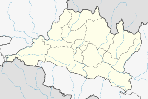
Nepal measures about 880 kilometers (547 mi) along its Himalayan axis by 150 to 250 kilometers across. It has an area of 147,516 km2 (56,956 sq mi).

<span class="mw-page-title-main">Geography of Paraguay</span>

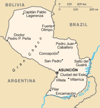
Paraguay is a country in South America, bordering Argentina, Bolivia and Brazil. The Paraguay River divides the country into strikingly different eastern and western regions. Both the eastern region and the western region gently slope toward and are drained into the Paraguay River, which separates and unifies the two regions. With the Paraneña region reaching southward and the Chaco extending to the north, Paraguay straddles the Tropic of Capricorn and experiences both subtropical and tropical climates.

<span class="mw-page-title-main">Geography of Syria</span> Geographical features of Syria

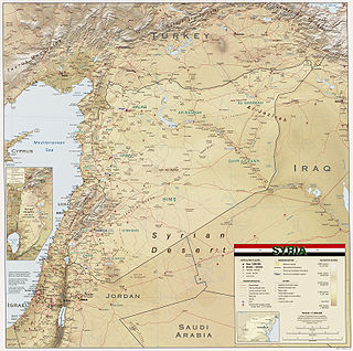
Syria is located in West Asia, north of the Arabian Peninsula, at the eastern end of the Mediterranean Sea. It is bordered by Turkey to the north, Lebanon and Israel to the west and southwest, Iraq to the east, and Jordan to the south. It consists of mountain ranges in the west and a steep area inland. In the east is the Syrian Desert and in the south is the Jabal al-Druze Range. The former is bisected by the Euphrates valley. A dam built in 1973 on the Euphrates created a reservoir named Lake Assad, the largest lake in Syria. The highest point in Syria is Mount Hermon on the Lebanese border at 2,814 metres or 9,232 feet. Between the humid Mediterranean coast and the arid desert regions lies a semiarid steep zone extending across three-quarters of the country, which receives hot, dry winds blowing across the desert. Syria is extensively depleted, with 28 percent of the land arable, 4 percent dedicated to permanent crops, 46 percent utilized as meadows and pastures, and only 3 percent forest and woodland.

<span class="mw-page-title-main">Langtang</span> Region in Nepal

Langtang Valley also known as Lamtang Valley is a Himalayan valley in the mountains of north-central Nepal, known for its trekking routes and natural environment.

<span class="mw-page-title-main">Darchula District</span> District in Sudurpashchim Province, Nepal

Darchula District, a part of Sudurpashchim Province, is one of the nine districts of province and one of seventy-seven districts of Nepal. The district, with Khalanga as its district headquarters, covers an area of 2,322 km2 (897 sq mi) and has a population (2011) of 133,274. Darchula lies in the west-north corner of the country.

<span class="mw-page-title-main">Mustang District</span> District in Gandaki Province, Nepal

Mustang District is one of the eleven districts of Gandaki Province and one of seventy-seven districts of Nepal which was a Kingdom of Lo-Manthang that joined the Federation of Nepal in 2008 after abolition of the Shah dynasty. The district covers an area of 3,573 km2 (1,380 sq mi) and in 2011 had a population of 13,452. The headquarters is located at Jomsom. Mustang is the fifth largest district of Nepal in terms of area.

<span class="mw-page-title-main">Rasuwa District</span> District in Bagmati Province, Nepal

Rasuwa District (Nepali: रसुवा जिल्ला is one of 13 districts of Bagmati Province and one of seventy-seven districts of Nepal. The district, with Dhunche as its district headquarters, covers an area of 1,544 km2 and has a population of 43,300. Its own District Post Office has a Rasuwa DPO code of 45000. There are 5 post offices in the district, aiding residents with postal services throughout the area. As per census 2011 total households in Rasuwa district is 9,778. It is the smallest district by area, among 16 districts in the Himalaya region of Nepal.

<span class="mw-page-title-main">Sindhupalchowk District</span> District in Bagmati Pradesh, Nepal

Sindhupalchowk District is a part of Bagmati Province and one of the seventy-seven districts of Nepal, with an area of 2,542 km2 (981 sq mi). The district's headquarters is in Chautara. In 2006, 336,478 people resided in 79 village development committees, in 2011 there were 287,798.

<span class="mw-page-title-main">Ventura River</span> River in western Ventura County in southern California, United States

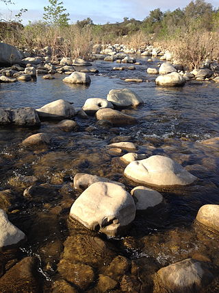
The Ventura River, in western Ventura County in southern California, United States, flows 16.2 miles (26.1 km) from its headwaters to the Pacific Ocean. The smallest of the three major rivers in Ventura County, it flows through the steeply sloped, narrow Ventura Valley, with its final 0.7 miles (1.1 km) through the broader Ventura River estuary, which extends from where it crosses under a 101 Freeway bridge through to the Pacific Ocean.

<span class="mw-page-title-main">Arun River (China–Nepal)</span> River in China and Nepal

The Arun River is a trans-boundary river and is part of the Kosi or Sapt Koshi river system in Nepal. It originates in Tibet Autonomous Region of the People's Republic of China where it is called the Phung Chu or Bum-chu.

<span class="mw-page-title-main">Tambo River (Victoria)</span> River in Victoria, Australia

The Tambo River or Berrawan is a perennial river of the Mitchell River catchment, located in the East Gippsland region of the Australian state of Victoria. With a total length in excess of 186 kilometres (116 mi), the Tambo River is one of the longest rivers in the East Gippsland drainage basin, extending from the steep forested southern slopes of the Victorian Alps through forest and farmland to the Gippsland Lakes.

<span class="mw-page-title-main">Sundarijal</span> Village of Gokarneshwar Municipality in No. 3, Nepal

Sundarijal is a village and former Village Development Committee that is now part of Gokarneshwar Municipality in Kathmandu district in Province No. 3 of central Nepal.

<span class="mw-page-title-main">Langtang, Rasuwa</span> Village development committee in Bagmati Zone, Nepal

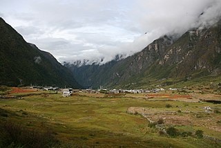
Langtang was a village development committee (VDC) in Rasuwa District in the Bagmati Zone of northern Nepal. It was located within the Langtang valley, approximately 40 miles northeast of Kathmandu. At the time of the 1991 Nepal census it had a population of 468 people living in 100 individual households.

<span class="mw-page-title-main">Sharda River</span> River along the India–Nepal border

The Sharda River, also called Kali River and Mahakali River, originates at Kalapani in the Himalayas at an elevation of 3,600 m (11,800 ft) in the Pithoragarh district in Uttarakhand, India. It flows along Nepal's western border with India and has a basin area of 14,871 km2 (5,742 sq mi). It joins Ghaghra River, a tributary of the Ganges. It takes the name Kali River from the union of the two streams at Gunji as it flows through the hills. After Brahmadev Mandi near Tanakpur, it enters the Terai plains, where it is called Sharda River.

<span class="mw-page-title-main">Little Salmon River</span> River in Idaho, United States

The Little Salmon River is a tributary of the Salmon River in Idaho. The river is approximately 51 miles (82 km) long and drains 576 square miles (1,490 km2) of land.

<span class="mw-page-title-main">Indravati River (Nepal)</span> River in Nepal

The Indravati River in Nepal is a tributary of the Sun Koshi River. It used to be called "Melamchi" or "Melamchu" until the 19th century.

<span class="mw-page-title-main">Gaurishankar Conservation Area</span>

Gaurishankar Conservation Area is a protected area in the Himalayas of Nepal that was established in January 2010, covering 2,179 km2 (841 sq mi) in the Ramechhap, Dolakha and Sindhupalchok districts and encompassing 22 Village Development Committees. It is contiguous with Tibet in the north and a part of the Sacred Himalayan Landscape. The protected area connects the Langtang and Sagarmatha National Parks. In 2010, the Government of Nepal handed over the management of Gaurishankar Conservation Area to National Trust for Nature Conservation for 20 years, which has been managing the area through its Gaurishankar Conservation Area Project.

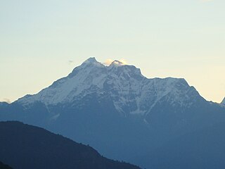
The ecology of the Himalayas varies with climate, rainfall, altitude, and soils. The climate ranges from tropical at the base of the mountains to permanent ice and snow at the highest elevations. The amount of yearly rainfall increases from west to east along the southern front of the range. This diversity of climate, altitude, rainfall and soil conditions supports a variety of distinct plant and animal species, such as the Nepal gray langur

Panchpokhari Thangpal is a rural municipality located in Sindhupalchok District of Bagmati Province of Nepal. The RM is surrounded by Jugal in the East, Helambu in the West, Rasuwa District covers from North and Melamchi and Indrawati falls in South of the RM.

<span class="mw-page-title-main">Melamchi River</span> River of Nepal

Melamchi River is a tributary of the Indrawati River. It originates from the Jugal Himal at an elevation of about 5,875 m (19,275 ft) above sea level. It joins the Indrawati River at Melamchi Bazaar.

References

  1. "Nepal Census 2001". Nepal's Village Development Committees. Digital Himalaya. Archived from the original on October 12, 2008. Retrieved 2008-08-24.
  2. "Death toll in quake-hit Sindhupalchok stands at 1‚820". The Himalayan. The Himalayan. 1 May 2015. Retrieved 1 May 2015.