Nuwakot District (Nepali: नुवाकोट जिल्लाListen , a part of Bagmati Province, is one of the seventy-seven districts of Nepal. The district, with Bidur as its district headquarters, covers an area of 1,121 km2 and had a population of 288,478 in 2001 and 277,471 in 2011. It is a historically important district in Nepal. Prithvi Narayan Shah died in Devighat of Nuwakot.

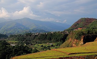
Bandipur is a hilltop settlement and a rural municipality in Tanahun District, Gandaki province of Nepal. Bandipur is primarily known for its preserved, old time cultural atmosphere. At the time of the 2011 Nepal census it had a population of total 15,591 people living in 3,750 individual households.
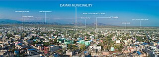
Damak, a city in eastern Nepal, is one of the oldest municipalities in Jhapa District in Koshi Province in eastern Nepal. It is situated between the Ratuwa River in the east and the Maawa River in the west. It has Sivalik Hills in its north and ends with the intersection of Ratuwa River and Maawa River in the south. Mahendra Highway crosses this municipality nearly bisecting it. It is the third largest city in Jhapa District with a population of 107,410 in 2021.

Sundarijal is a village and former Village Development Committee that is now part of Gokarneshwar Municipality in Kathmandu District in Province No. 3 of central Nepal.
Ratnanagar is a municipality in Chitwan District of Bagmati Province in Nepal. It is the second biggest municipality after Bharatpur Metropolitan City that was formed in 1997 through the merger of the former Village Development Committees Old-Ratnanagar and Panchakanya. It is adjacent to Chitwan National Park, and serves as a gateway to the park. Agricultural products produced from Ratnanagar includes rice, maize, mustard and vegetables. This municipality is also a major place for production of poultry products and animal husbandry. Tourism is another source of income generation for the people in Ratnanagar. People are directly or indirectly dependent in tourism industry. Ratnanagar is also concerned in environment preservation so in order to preserve and protect environment, eco-friendly electric risk-shaw has also been introduced and available in different parts of this municipality. It lies on the bank of East Rapti River.

Panchkhal is a Municipality in Kavrepalanchok District in the Bagmati Province of central Nepal. Panchkhal has an area of 103 km² and Density: 386.6/km² according to 2011 census. Glacial strand retreat and fluvial incision led to develop landscapes and evolve the area having a relief of about 122 to 750 m. At the time of the 2011 Nepal census it had a population of 35340 & 8948 houses combining of previous VDC that were merged. Previous Aniakot, HokseBazar, Kharelthok, Koshidekha, Baluwa & Panchkhal VDC was merged to form agriculturally rich Panchkhal Municipality.
Phakphok is a town and Village Development Committee (VDC) in Ilam District in the Province No. 1 of eastern Nepal. At the time of the 1991 Nepal census it had a population of 4,233 persons living in 734 individual households.
Lamatar is a village and former Village Development Committee that is now part of Mahalaxmi Municipality in Bagmati Province of central Nepal.
Kharmi is a town and Village Development Committee in Khotang District in the Sagarmatha Zone of eastern Nepal. At the time of the 1991 Nepal census it had a population of 3,807 persons living in 723 individual households.
Kaskikot, commonly known as Kaski, is a Ward no. 24 of the Pokhara metropolitan city. It was earlier a part of the village development committee in Kaski District, a region in northern-central Nepal.

Manthali is a municipality and the headquarters of Ramechhap District in Bagmati Province, Nepal that was established on 2 December 2014 by merging the former village development committees Old-Manthali, Bhatauli, Chisapani, Kathjor, Bhaluwajor, Salupati and Sunarpani. It was declared the headquarters of the district on 9 March 1989. It lies on the bank of the Tamakoshi River. At the time of the 2011 Nepal census it had a population of 45,416 people living in 10,099 individual households.

Dudhauli is a municipality of the Sindhuli District in the Janakpur Zone of south-eastern Nepal.

Phidim Municipality is the headquarters of the Panchthar District in the Province No. 1 of eastern Nepal. Phidim was upgraded to a 'municipality' from a 'village', when a development committee merged with other VDCs - including the Phidim, Chokmagu and Siwa villages - on May 18, 2014. It offers a route for trekkers and locals, who travel to and from the Taplejung district bordering with the Tibetan Autonomous Region of China. It is also a commercial hub for the rural surroundings.
Rajghat is a small village in the Urlabari Municipality, comprising two wards; 8 and 9 in the Morang District in the Koshi Zone of south-eastern Nepal. It is located in North-East part of Morang and 1.5 kilometers south of the East West national highway of Nepal. Durgapuri Bazar is the local town of Rajghat. This place is one of the major habitat of indigenous Dhimal, Santhal,and Mushahar communities.
Popularly known as Daman or Palung or Tistung - Palung, Thaha Municipality is a municipality in Makwanpur District of Bagmati Province in mid Nepal. In Nepali Thaha, (थाहा) means to know. It was one of the biggest communist political movement led by hon. Rupchandra Bista. He started the Thaha Movement which is dedicated to his contributions to this region.
Ratuwamai is a municipality and rural town situated in south-eastern Terai in Morang district and Koshi Province of Nepal. This municipality was formed merging six village development committee i.e. Sijuwa, Itahara, Jhurkiya, Mahadeva, Govindapur and Baradanga since March 2017. Total population is 55 thousand 3 hundred 80, area 142.15 km2 and the number of voters is 42 thousand 4 hundred. The main Occupation of this municipality is the Agriculture, most of the people earn money by farming. Sombare, Itahara, Laxmichock, Damravitta, Sijuwa, Sauntha, Shanichare, Govindapur, Kalyanpur and Jhurkiya are the most developing places in the Municipality. The borders are as following: East Jhapa District, West Sunawarshi Municipality and Pathari-Sanischare Municipality, North Urlabari Municipality and South Bihar State India.
Phakphokthum is a rural municipality, one of six located in Ilam District of Koshi Province of Nepal. A total of 10 municipalities are found in Ilam, of which 4 are urban and 6 are rural.
Thuli Bheri is an urban municipality located in Dolpa District of Karnali Province of Nepal. The district headquarter of Dolpa lies in Dunai, which is a village in the south-east of Thuli Beri.

Namkha is the largest rural municipality of Nepal located in Humla District of Karnali Province.

Kalinchowk is a Rural municipality located within the Dolakha district of the Bagmati province of Nepal. The municipality spans 132.49 square kilometres (51.15 sq mi) of area, with a total population of 22,954 according to a 2011 Nepal census.

