Chautara

Last updated

Chautara Sangachokgadhi Municipality
NepalSindhupalchokDistrictmap.png
Sindhupalchowk District
Nepal Bagmati adm location map.svg
Red pog.svg
Chautara Sangachokgadhi Municipality
Location in Nepal
Nepal adm location map.svg
Red pog.svg
Chautara Sangachokgadhi Municipality
Chautara Sangachokgadhi Municipality (Nepal)
Coordinates: 27°46′N85°42′E / 27.767°N 85.700°E / 27.767; 85.700
CountryFlag of Nepal.svg    Nepal
Province Bagmati Province
District Sindhupalchowk District
Population
  Total51,347
  Religions
Hindu Buddhism
Time zone UTC+5:45 (NST)
Postal code
45300
Area code 011
Website www.chautaramun.gov.np

Chautara Sangachokgadhi is a municipality in Sindhupalchowk District in Bagmati Province of central Nepal. The municipality was established on 18 May 2014 by merging Pipaldanda, Chautara, Kubhinde, Sanusiruwari Village Development Committees as Chautara Municipality. Later on 2017 it was expended again merging Sangachok, Thulo Sirubari, Kadambas, Irkhu, Batase and Syaule Village Development Committees to form Chautara Sangachowkgadi Municipality. It is now divided to 14 wards. This is the district headquarters of the Sindhupalchowk District. The municipality stands at the elevation of approximately 1,600 m above sea level. Religious and cultural festivities form a major part of the lives of people residing in Chautara. There are people of various religious beliefs, Hinduism, Buddhism and Christianity as well, giving Chautara a cosmopolitan culture. Nepali is the most commonly spoken language in the municipality. Likewise, Newari and other languages such as Tamang is also spoken as the Newars and Tamangs dominate the settlement in population.

Contents

Geography

Chautara is located in the northern part of Nepal and covers an area of around 50 square kilometers. The average elevation is 1,600 metres above sea level. Chautara is in the Deciduous Monsoon Forest Zone, one of five vegetation zones defined for Nepal. The dominant tree species in this zone are oak, pine, beech, maple and others, with coniferous trees at higher altitude.

Ethnic groups

The largest ethnic groups are Sherpa, Newar, Brahmin, Chhetri, Gurung, Magars, Tamang, etc. The major languages are Newar, Tamang, Nepali, Nepal Bhasa and English is understood by majority of people. The major religions are Hinduism, Buddhism and Christianity.

Cuisine

The staple food of the people of Chautara is dal bhat. It consists of rice and lentil soup, generally served with vegetable curries, achar and sometimes chutney. Momo, a type of Nepali version of Tibetan dumpling, has become prominent in Chautara with many street vendors selling it. It is one of the most popular fast foods in Chautara. Various Nepali variants of momo including buff momo, chicken momo, and vegetarian momo are famous in Chautara. However, the practice of vegetarianism is not uncommon, and vegetarian cuisines can be found throughout the city. Buff (meat of water buffalo) is very common. The chief breakfast for locals and visitors is mostly Momo or Chowmein.

Festivals

The festivities such as the Loshar, Dashain, Tihar, Shivratri and many more are observed by all Hindu and Buddhist communities of Chautara. Some of the traditional festivals observed in Chautara apart from those previously mentioned, are Loshar, Bada Dashain, Tihar, Maghe Sankranti, Naga Panchami, Janai Poornima, Teej/Rishi Panchami, Gaurati Jatra, saune sagrati etc.

Sports

Football and Cricket are the most popular sports among the younger generation in Chautara. The only ground in the city is the Chautara Tudhikhel Ground, a multi-purpose ground used mostly for football matches and cultural events. Several football matches are conducted in this ground every year. Chautara is home to the football clubs such as Chautara Sporting Club (CSC), Bhotechour sports club from melamchi-1, Star Club, Kshitiz Club, Tol Sudharetc.

Media

To Promote local culture, Chautara has two FM radio stations. Radio Sindhu - 105 MHz which is a community radio station and the newly established Radio Planet - 89.1 MHz situated near the bus park of Chautara. Sundar Shireesh has publish a Bihanee Media Homes, Bihanee Times Weekly, www.aksharpati.com, Sindhu Jagaran Weekly and many more Media.

2015 Nepal Earthquake

The town was severely affected by the earthquake on 25 April 2015. Over ninety percent of the homes in the town had been destroyed. The main hospital of the town had collapsed. [1] The town suffered from water shortages. [2] Relief workers and the Nepali army met government officials in Chautara to discuss the emergency response to the humanitarian crisis. However, government officials have stayed out of sight due to the anger of the residents of the town. Dozens of people crowded in front of the administrative office in Chautara, demanding that officials deliver more tents to earthquake survivors sleeping without shelter. The government had tents, but they were not given to the residents of the town. [3]

Related Research Articles

<span class="mw-page-title-main">Kathmandu</span> Capital and largest city in Nepal

Kathmandu, officially Kathmandu Metropolitan City, is the capital and most populous city of Nepal with 845,767 inhabitants living in 105,649 households in 2021 and 2.9 million people in its urban agglomeration. It is located in the Kathmandu Valley, a large valley in the high plateaus in central Nepal, at an altitude of 1,400 metres.

<span class="mw-page-title-main">Kirtipur</span> Municipality in Bagmati Province, Nepal

Kirtipur is a Municipality and an ancient city of Nepal. The Newars are the natives of Kipoo (Kirtipur) that is believed to be derived from Kirati King Yalamber. It is located in the Kathmandu Valley 5 km south-west of the city of Kathmandu. It is one of the five dense municipalities in the valley, the others being Kathmandu, Lalitpur, Bhaktapur and Madhyapur Thimi. It is one of the most famous and religious places to visit. Many people visit this place not only for its natural environment but also to visit temples. The city was listed as a UNESCO tentative site in 2008.

<span class="mw-page-title-main">Momo (food)</span> Type of dumpling from Tibet

Momo is a type of steamed filled dumpling with origins from the Himalayan region that is popular in Tibet, Bhutan, Nepal and India. In Nepal, where it is considered a national dish, they are usually served with a sauce known as achar influenced by the spices and herbs used within many South Asian cuisines. It can also be cooked as soup versions known as jhol momo where the broth is made from achar using a mixture of tomatoes, sesame seeds, chillies, cumin and coriander or mokthuk from boiling pork/buffalo bones mixing with various herbs and vegetables.

<span class="mw-page-title-main">Culture of Nepal</span> Overview of the Nepalese culture

The culture of Nepal encompasses the various cultures belonging to the 125 distinct ethnic groups present in Nepal. The culture of Nepal is expressed through music and dance; art and craft; folklore; languages and literature; philosophy and religion; festivals and celebration; foods and drinks.

<span class="mw-page-title-main">Kathmandu District</span> District in Bagmati Province, Nepal

Kathmandu District is a district located in Kathmandu Valley, Bagmati Province of Nepal. It is one of the 77 districts of Nepal, covers an area of 413.69 km2 (159.73 sq mi), and is the most densely populated district of Nepal with 1,081,845 inhabitants in 2001, 1,744,240 in 2011 and 2,017,532 in 2021. The administrative headquarters of Kathmandu district is located in Kathmandu. The city has 21 post offices which handle mail from across the country and beyond, with Kathmandu DPO having 44,600 as its postal code for international mail delivery services like UPS or DHL Couriers etc.

<span class="mw-page-title-main">Lamjung District</span> District in Gandaki Province, Nepal

Lamjung District, a part of Gandaki Province, is one of the 77 districts of Nepal. The district, with Besisahar as its district headquarters, covers an area of 1,692 square kilometres (653 sq mi) and as of 2011 had a population of 167,724. Lamjung lies in the mid-hills of Nepal spanning tropical to trans-Himalayan geo-ecological belts, including the geographical midpoint of the country. It has mixed habitation of casts and ethnicities. It is host to probably the highest density of the Gurung ethnic population in the country.
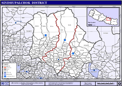
<span class="mw-page-title-main">Saptari District</span> District in Madhesh Pradesh

Saptari, a part of Madhesh Province, is one of the seventy-seven districts of Nepal. Its district headquarter is Rajbiraj. Saptari is an Outer Terai district. This district covers an area of 1,363 km2 (526 sq mi) and has a population (2011) of 639,284 which makes it the 10th most populated district of Nepal. Saptari is renowned for its agricultural output, and is bordered on the east by the massive Sapta Koshi river.

<span class="mw-page-title-main">Sindhupalchowk District</span> District in Bagmati Pradesh, Nepal

Sindhupalchowk District is a part of Bagmati Province and one of the seventy-seven districts of Nepal, with an area of 2,542 km2 (981 sq mi). The district's headquarters is in Chautara. In 2006, 336,478 people resided in 79 village development committees, in 2011 there were 287,798.

<span class="mw-page-title-main">Baglung</span> Place in Gandaki Province, Nepal

Baglung is a municipality in Gandaki Province, in western Nepal, 275 km (171 mi) west of Kathmandu. It is the administrative headquarters of Baglung District. Baglung serves as the major center for business, finance, education, service and healthcare for the people of mid-Kali Gandaki valley that encompass Beni, Jaljala, Baglung, Kushma, Kathekhola, Galkot, Phalewas and Jaimuni local bodies. The city is located at the cross-section of Kaligandaki corridor highway and midhill highway that transverse Nepal in north–south and east–west directions respectively.

<span class="mw-page-title-main">Bhimdatta</span> Municipality in Sudurpashchim Province, Nepal

Mahendranagar officially known as Bhimdattanagar (Nepali:भिमदत्त), is a municipality in Kanchanpur District of Sudurpashchim Province, Nepal. The city and the municipality were named Mahendranagar in the honour of late King Mahendra of Nepal. After becoming a republic in 2008, the Mahendranagar municipality name was changed to Bhimdatta municipality in honour of the revolutionary farmer leader Bhimdatta Panta. It is surrounded by Bedkot Municipality in the east, Dadeldhura District in the north, Shuklaphanta National Park in the south and Uttarakhand, India in the west.

<span class="mw-page-title-main">Nepalese cuisine</span> Culinary traditions of Nepal

Nepali cuisine comprises a variety of cuisines based upon ethnicity, alluvial soil and climate relating to Nepal's cultural diversity and geography. Dal-bhat-tarkari is eaten throughout Nepal. Dal is a soup made of lentils and spices, bhat — usually rice but sometimes another grain — and a vegetable curry, tarkari. Condiments are usually small amounts of spicy pickle which can be fresh or fermented, mainly of dried mustard greens and radish and of which there are many varieties. Other accompaniments may be sliced lemon (nibuwa) or lime (kagati) with fresh green chilli and a fried papad and also Islamic food items like rice pudding, sewai, biryani etc. Dhindo (ढिंडो) is a traditional food of Nepal. A typical example of Nepali cuisine is the Chaurasi Byanjan set where bhat (rice) is served in a giant leaf platter (patravali) along with 84 different Nepali dishes each served on small plates. It is mostly fed during weddings and Pasni(rice feeding ceremony).

<span class="mw-page-title-main">Gorkha Municipality</span> Municipality in Gandaki Province, Nepal

Gorkha is a municipality in Gorkha District in Gandaki Province of Nepal created in 1996. It was initially named "Prithibinarayan" after King Prithvi Narayan Shah, who was born in Gorkha and united and founded modern Nepal. In 2009, the name was changed to "Gorkha" municipality after the end of the monarchy in Nepal. At the time of the 2021 Nepal census it had a population of 53,285 people living in 12,641 individual households. In 2014, the neighboring Village development committees Nareshwar and Phinam were merged into the municipality.

<span class="mw-page-title-main">Culture of Darjeeling</span> Overview of the culture of Darjeeling, (India)

The culture of Darjeeling, India, is diverse and has a regional distinctness.

<span class="mw-page-title-main">Outline of Nepal</span> Overview of and topical guide to Nepal

The following outline is provided as an overview of and topical guide to Nepal:

<span class="mw-page-title-main">Bhimeshwar</span> Municipality in Bagmati Province, Nepal

Bhimeshwar,, is a municipality in north-eastern Nepal and the headquarters of Dolakha District in Bagmati Province that was established in 1997 by merging the former Village development committees Charikot, Dolakha Town, Makaibari and Mati. At the time of the 2011 Nepal census it had a population of 32,486 people living in 8,639 individual households. The town is located at an altitude of 1554 metres (5101 feet). The name of the district Dolakha came from Dolakha Town situated north-east of the headquarters Charikot Bazaar.

Sangachok is a village and market center of Chautara Sangachokgadi Municipality in Sindhupalchok District in the Bagmati Zone of central Nepal. The formerly Village Development Committee was merged to form the new municipality on 2017. At the time of the 2013 Nepal census it had a population of 10,791 and had 1,828 houses in the village.

The 2015 Nepal National League also known as the RedBull National League for sponsorship reasons is the 2nd edition of Nepal National League. The winners Three Star Club received 1 Crore or 10,000,000 rupees.

<span class="mw-page-title-main">Bagmati Province</span> Province in central Nepal

Bagmati Province is one of the seven provinces of Nepal established by the constitution of Nepal. The province is Nepal's second-most populous province and fifth largest province by area. Bagmati is bordered by Tibet Autonomous Region of China to the north, Gandaki Province to the west, Koshi Pradesh to the east, Madhesh Province and the Indian state of Bihar to the south. With Hetauda as its provincial headquarters, the province is also the home to the country's capital Kathmandu, is mostly hilly and mountainous, and hosts mountain peaks including Gaurishankar, Langtang, Jugal, and Ganesh.

<span class="mw-page-title-main">Dance in Nepal</span> Aspect of Nepalese culture

Dance is a performing art form consisting of purposefully selected sequences of human movement. Dance (Nepali: नृत्य/ नाच) in Nepal comprises numerous styles of dances, including folk, ethnic, classical to modern dances. Lakhey is the dance of a demon in the carnival of God. Durbar Square, a historic plaza in Kathmandu, Nepal, facing ancient palaces and adorned by Hindu temples, is always full of eager crowds on the last day of Indra Jatra, the festival celebrating Indra, the Hindu king of heaven. In this divine stage, Lakhe the demon dances among gods and deities relentlessly and carelessly.

References

  1. "Red Cross calls for greater urgency in relief efforts for Nepal earthquake survivors". International Federation of Red Cross and Red Crescent Societies (IFRC). International Federation of Red Cross and Red Crescent Societies (IFRC). 30 April 2015. Archived from the original on 10 September 2016. Retrieved 10 September 2016.
  2. Lee, Briana (30 April 2015). "Nepal Earthquake: In Tent Cities, Water Shortages, Open Toilets Add To Fears Of Looming Health Disaster". International Business Times. International Business Times. Archived from the original on 9 May 2015. Retrieved 10 September 2016.
  3. Lee, Briana (29 April 2015). "Nepal Earthquake: Wait For Relief Swells Into Anger In Villages Outside Kathmandu". International Business Times. International Business Times. Archived from the original on 11 September 2016. Retrieved 10 September 2016.