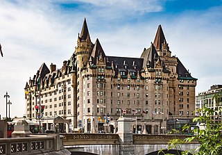
The Fairmont Château Laurier is a 660,000-square-foot (61,000 m2) hotel with 429 guest rooms in the downtown core of Ottawa, Ontario, Canada, located near the intersection of Rideau Street and Sussex Drive and designed in a French Gothic Revival Châteauesque style to complement the adjacent Parliament buildings. The hotel is above the Colonel By Valley, home of the Ottawa Locks of the Rideau Canal, and overlooks the Ottawa River. The main dining room overlooks Major's Hill Park. The reception rooms consist of the Wedgewood-blue Adam Room, the Laurier Room defined with Roman columns, the Empire-style ballroom, and the Drawing Room decorated with cream and gold plaster ornament. The hotel was designated a national historic site in 1980.

Rideau Street is a major street in downtown Ottawa, Ontario, Canada, and one of Ottawa's oldest and most famous streets running from Wellington Street in the west to Montreal Road in the east where it connects to the Vanier district. Rideau Street is home to the Château Laurier, the CF Rideau Centre and the Government Conference Centre. Along with Wellington Street and Sussex Drive it was among the first streets in Ottawa to be host to businesses; it was created with the founding of the earlier settlement Bytown. The Plaza Bridge by the Rideau Canal is at its westernmost point and the Cummings Bridge is at its easternmost point.

Sussex Drive, also known as Ottawa Regional Road 93, is an arterial road in Ottawa, Ontario, the capital of Canada. It is one of the city's main ceremonial and institutional routes. Travelling roughly parallel to the Ottawa River, Sussex Drive begins as a continuation of Sir George-Étienne Cartier Parkway at Rideau Gate, at the entrance to Rideau Hall. It travels south to Rideau Street, with the portion south of St. Patrick Street forming the northbound half of a one-way pair with Mackenzie Avenue. Both Mackenzie Avenue and Sussex Drive connect with Colonel By Drive at their southern end, which continues south alongside the Rideau Canal.
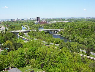
Colonel By Drive is an 8.1 km (5.0 mi) long scenic parkway in Ottawa, Ontario, Canada.

Downtown Ottawa is the central area of Ottawa, Ontario, Canada. It is sometimes referred to as the Central Business District and contains Ottawa's financial district. It is bordered by the Ottawa River to the north, the Rideau Canal to the east, Gloucester Street to the south and Bronson Avenue to the west. This area and the residential neighbourhood to the south are also known locally as 'Centretown'. The total population of the area is 5,501.

Lees Avenue is both a road and a neighbourhood in Ottawa, Ontario, Canada. The area lies in the narrow stretch between the Rideau Canal and Rideau River south of Sandy Hill and the Queensway and is part of Old Ottawa East. The neighbourhood is dominated by five large apartment buildings, some of the largest in Ottawa. These buildings range from low cost to moderate cost and mostly house new immigrants, students and young professionals. Across the Rideau River to the east Hurdman is a more recently built such area.

Thomas McKay was a Canadian businessman who was one of the founders of the city of Ottawa, Ontario.
The Bytown and Prescott Railway (B&PR) was a railway joining Ottawa with Prescott on the Saint Lawrence River, in the Province of Canada. The company was incorporated in 1850, and the first train ran from Prescott into Bytown on Christmas Day, 1854. The 84 kilometres (52 mi) railway, Ottawa's first to outside markets, was initially used to ship lumber collected on the Ottawa River for further shipping along the St. Lawrence to markets in the United States and Montreal.

Queen Elizabeth Driveway is a scenic parkway in Ottawa, Ontario, Canada.
LeBreton Flats, known colloquially as The Flats, is a neighbourhood in Somerset Ward in central Ottawa, Ontario, Canada. It lies to the west of Centretown neighbourhood, and to the north of Centretown West. The Ottawa River forms the western and northern limit, with the western side being a wider area of the river known as Nepean Bay.

Confederation Park(French: Parc de la Confédération) is a public park and National Historic Site of Canada, located in the downtown core of Ottawa, Ontario, Canada. It is bordered on the south by Laurier Avenue and Ottawa City Hall; on the east by the Rideau Canal and National Defence Headquarters; on the north by the Mackenzie King Bridge, the Rideau Centre and the National Arts Centre; and to the west by Elgin Street and the Lord Elgin Hotel.
The Canada Atlantic Railway (CAR) was a North American railway located in Ontario, southwestern Quebec and northern Vermont. It connected Georgian Bay on Lake Huron with the northern end of Lake Champlain via Ottawa. It was formed in 1879 through a merger of two separate railway companies that John Rudolphus Booth had purchased, and reached its full extent in 1899 through a third company that he had created. The CAR was owned by Booth for several years after its completion until he agreed to sell it to the Grand Trunk Railway (GTR) in 1904.

The architecture of Ottawa is most marked by the city's role as the national capital of Canada. This gives the city a number of monumental structures designed to represent the federal government and the nation. It also means that as a city dominated by government bureaucrats, much of its architecture tends to be formalistic and functional. However, the city is also marked by Romantic and Picturesque styles of architecture such as the Parliament Building's Gothic Revival architecture.
The Plaza Bridge in Ottawa, Ontario, Canada, is an automotive and pedestrian bridge that crosses the Rideau Canal just south of the Ottawa locks. It joins Wellington Street and Elgin Street in the Downtown core to the west with Rideau Street to the east. The Chateau Laurier abuts the bridge at the east end, while Parliament Hill is just beyond the west end. It is the northernmost bridge over the canal, just north of the Mackenzie King Bridge.
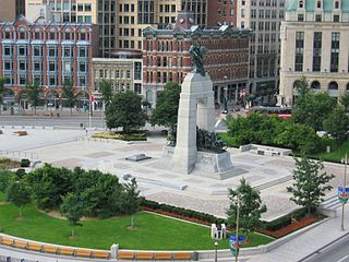
Confederation Square is an urban square in Ottawa, Ontario, Canada, and is considered the second most important ceremonial centre in Canada's capital city, after Parliament Hill. Roughly triangular in area, with Canada's National War Memorial at its centre and the Valiants Memorial at its periphery, the square is bounded by Wellington Street to the north and branches of Elgin Street to the east and west.
This is a timeline of the history of Ottawa.

Rogers Centre Ottawa is a convention centre located in the downtown core of Ottawa, Ontario, Canada. It opened in April 2011. The award-winning architecture was designed by Ritchard Brisbin. The Centre replaces the Ottawa Congress Centre, which opened in 1983 and is built on the site of the Ottawa Congress Centre building which was demolished in 2008–2009.
The history of Ottawa, capital of Canada, was shaped by events such as the construction of the Rideau Canal, the lumber industry, the choice of Ottawa as the location of Canada's capital, as well as American and European influences and interactions. By 1914, Ottawa's population had surpassed 100,000 and today it is the capital of a G7 country whose metropolitan population exceeds one million.

Rideau is a station on the O-Train Confederation Line on Rideau Street on the border of the Sandy Hill and ByWard Market neighbourhoods in Central Ottawa, Ontario, Canada.

 The Senate of Canada Building faces Rideau Street
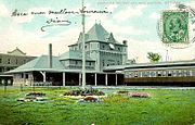 Broad Street Station, 1908, replaced a station lost in the great 1900 Hull–Ottawa fire
 Construction of the station with view of railway lines and the Rideau Canal
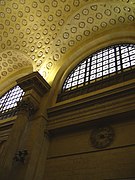 Interior view of Waiting Room, which was inspired by the Baths of Caracalla
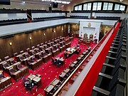 Temporary chamber, in use while Centre Block undergoes renovations


