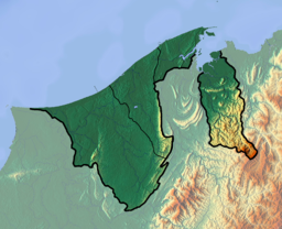
Bandar Seri Begawan (BSB) is the capital and largest city of Brunei. It is officially a municipal area with an area of 100.36 square kilometres (38.75 sq mi) and an estimated population of 100,700 as of 2007. It is part of Brunei–Muara District, the smallest yet most populous district which is home to over 70 per cent of the country's population. It is the country's largest urban centre and nominally the country's only city. The capital is home to Brunei's seat of government, as well as a commercial and cultural centre. It was formerly known as Brunei Town until it was renamed in 1970 in honour of Omar Ali Saifuddien III, the 28th Sultan of Brunei and the father of Sultan Hassanal Bolkiah.

Belait District or simply known as Belait, is the largest as well as the westernmost district in Brunei. It has an area of 2,727 square kilometres (1,053 sq mi) and the population of 65,531 as of 2021. The administrative town is Kuala Belait, located at the mouth of the 32 kilometres (20 mi) long Belait River. The district is commonly associated with the oil and gas industry of the country, mainly concentrated near the town of Seria.
Brunei–Muara District or simply known as Brunei–Muara, is the smallest as well as the most populated district in Brunei. It has an area of 571 square kilometres (220 sq mi) and the population of 318,530 as of 2021. The district is also home to its administrative centre is Bandar Seri Begawan, as well as the Brunei International Airport and Muara Port, the country's only international airport and deep-water port respectively. The Brunei River flows within this district and is home to Kampong Ayer. As the administrative center of Brunei is located in the district, it remains the most developed in the country with the most up-to-date infrastructure, despite not being the center of Brunei's main economic activity.

Tutong District or simply known as Tutong, is the third largest and populated district in Brunei. It has an area of 1,166 square kilometres (450 sq mi) and the population of 47,210 as of 2021. The district is also home to its administrative centre is Tutong Town, as well as the Tutong River and Tasek Merimbun, the country's second longest river and the only ASEAN Heritage Parks in Brunei respectively.

Temburong District or simply known as Temburong, is the second largest and least populated district in Brunei. It has an area of 1,306 square kilometres (504 sq mi) and the population of 9,444 as of 2021. The district is also home to its administrative centre, Bangar Town, as well as the Temburong River and Ulu Temburong National Park, the country's third longest river and a national park in Brunei respectively.

Muara or officially known as Muara Town, is a port town in Brunei-Muara District, Brunei, about 28 kilometres (17 mi) from the capital Bandar Seri Begawan. The population of the town proper was 2,102 in 2016. It is home to Muara Port, the country's primary deep water port.
Saiful Rijal was the sultan of Brunei from 1530 to 1581. He was succeeded by his eldest son Shah Brunei.

Seri Kenangan Beach, also known as Tutong Beach, is a beach and spit in Kuala Tutong, Mukim Pekan Tutong, Tutong District. It is located at an estimated distance of 2 km west of Tutong town. It can also be noted that clay soils were found in the areas around the beach.

The fishing industry in Brunei is one of the largest contributors of the country's revenue. Fishing is a major source of protein in the diets of the Brunei people. The coastal location on the island of Borneo makes it an ideal location for commercial and subsistence fishing.
Sibungor Island is an islet on the Brunei River in Brunei-Muara District, Brunei. A proposal for an 8 hectares protection status to be implemented on the island. The island is home to proboscis monkeys and forest swamps.

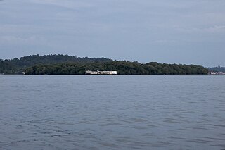
Muara Besar Island is an island in Mukim Serasa, Brunei-Muara District, Brunei. The island is essential for the Brunei–China relations due to its part in the Chinese Belt and Road Initiative. It can be noted that the island may be referred to Muara Island in older works.
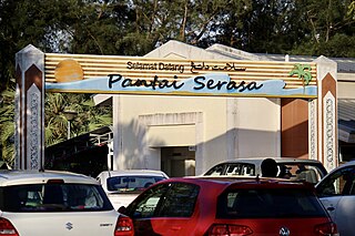
Serasa Beach is a 1.5 km long artificial split off the Serasa Bay, Mukim Serasa, Brunei-Muara District, Brunei. The beach also lies a few minutes from Muara port and town.
Egret oil field, also known as Egret Field, is a complex oil and gas field in the South China Sea and 45 km north-west of Seria, Belait District, Brunei. It is located at the depth of 60 m, and operated by Brunei Shell Petroleum (BSP).

Muara Beach is a beach in Muara, Mukim Serasa, Brunei-Muara District, Brunei. The beach used to stretch up to Pelumpong Spit, before they were cut apart in order to make way for easy access to Muara Port in the 1960s. The beach is located at an estimated distance of 27 km from Bandar Seri Begawan, and 3 km from Muara Port.

Penanjong Beach is a beach in Kampong Penanjong, Pekan Tutong, Tutong, Brunei Darussalam. The beach is known for water sport activities and view of sunsets over the South China Sea. It should also be noted that parts of the beach which stretches from Penanjong are located within a military base.

Tungku Beach is a Brunei Investment Agency (BIA) owned beach in Kampong Tungku, Gadong 'A', Brunei-Muara, Brunei. The beach is known for fishing, picnicking and view of sunsets over the South China Sea. The beach sits at an altitude of 76 metres (249 ft).

Belait Beach, also known as KualaBelait Beach, is a beach in Kuala Belait, Mukim Kuala Belait, Belait District, Brunei. The beach used to stretch from Kuala Belait to Pelumpong Spit but was cut and split at Muara Beach.

Lalak Lake is a pond in Mukim Labi, Belait District, Brunei. It is located within the Labi Hills Forest Reserve as part of the Luagan Lalak Recreation Park, and 100 kilometres (62 mi) from Bandar Seri Begawan. The Brunei Malay term "Luagan", refers to a natural pond or non-flowing body of water.

Selirong Island, also known as Mosquito Island, is an island located within the Brunei Bay and Mukim Labu, Temburong District, Brunei. The island also sits at the river delta of the Temburong River.

Berambang Island is an island at the southern bank of the Brunei River in the Mukim Kota Batu, Brunei-Muara District, Brunei. The island was formerly named Buang Tawer during The Brooke Era from 1841 until 1941. The mausoleum of the 9th Sultan of Brunei, Sultan Muhammad Hassan is located on the island, near Kampong Sungai Bunga.