Sesori

Last updated
Sesori
Municipality
Ciudad de Sesori, El Salvador. - panoramio.jpg
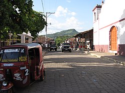
Ciudad de Sesori downtown
El Salvador location map.svg
Red pog.svg
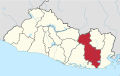
Sesori
Location in El Salvador
Coordinates: 13°43′N88°22′W / 13.717°N 88.367°W / 13.717; -88.367
CountryFlag of El Salvador.svg  El Salvador
Department San Miguel Department
Elevation
700 ft (200 m)
Websitefacebook.com/sesorences

Sesori is a municipality in the Department of San Miguel, El Salvador. [1] This is where many of the local people come and get food, supplies, education and it is also here where they get transportation to larger cities. Its location was used by other surrounding villages as people came here to make use of telephone services provided by ANTEL (Administracion Nacional de Telecomunicaciones).[ citation needed ]

Related Research Articles

<span class="mw-page-title-main">Arctic Archipelago</span> Canadian islands in the Arctic Ocean

The Arctic Archipelago, also known as the Canadian Arctic Archipelago, is an archipelago lying to the north of the Canadian continental mainland, excluding Greenland and Iceland.

This is a list of the extreme points of the United Kingdom: the points that are farther north, south, east or west than any other location. Traditionally the extent of the island of Great Britain has stretched "from Land's End to John o' Groats".

<span class="mw-page-title-main">Harper, Liberia</span> Place in Maryland County, Liberia

Harper, situated on Cape Palmas, is the capital of Maryland County in Liberia. It is a coastal town situated between the Atlantic Ocean and the Hoffman River. Harper is Liberia's 11th largest town, with a population of 17,837.

<span class="mw-page-title-main">San Francisco, Lempira</span> Municipality in Lempira, Honduras

San Francisco is a municipality in the Honduran department of Lempira.

<span class="mw-page-title-main">California, El Salvador</span> Municipality in Usulután department, El Salvador

California is a municipality in the Usulután department of El Salvador.

<span class="mw-page-title-main">Area codes 717 and 223</span> Telephone area codes in south central Pennsylvania, U.S.

Area codes 717 and 223 are telephone area codes in the North American Numbering Plan (NANP) for South Central Pennsylvania and the Susquehanna Valley. The numbering plan area (NPA) includes the Harrisburg, Lancaster, and York metropolitan areas and a considerable portion of Pennsylvania Dutch Country, an area with nearly two million people.

Lulsgate Plateau is the name given to the Carboniferous Limestone hills which form a northern outlier of the Mendip Hills, southwest of Bristol, England, approximately 600 feet (180 m) above sea level, which has been occupied since prehistoric times.

<span class="mw-page-title-main">Petrovo, Rožňava District</span>

Petrovo is a village and municipality in the Rožňava District in the Košice Region of middle-eastern Slovakia.

<span class="mw-page-title-main">Hraničné</span> Village and municipality in Slovakia

Hraničné is a village and municipality in Stará Ľubovňa District in the Prešov Region of northern Slovakia.

<span class="mw-page-title-main">Lower Saloum</span>

Lower Saloum is one of the ten districts of the Central River Division of the Gambia. Its population in the 2013 census was 15,881.

SM <i>U-27</i> (Germany)

SM U-27 was a German Type U-27 U-boat built for service in the Imperial German Navy. She was launched on 14 July 1913, and commissioned on 8 May 1914 with Kapitänleutnant Bernd Wegener in command.

<span class="mw-page-title-main">Santibáñez de Ecla</span> Municipality in Castile and León, Spain

Santibáñez de Ecla is a municipality located in the province of Palencia, Castile and León, Spain. According to the 2004 census (INE), the municipality has a population of 87 inhabitants.

<span class="mw-page-title-main">Brazacorta</span> Municipality and town in Castile and León, Spain

Brazacorta is a municipality and town located in the province of Burgos, Castile and León, Region of Ribera, Spain. According to the 2007 census (INE), the municipality had a population of 75 inhabitants.

<span class="mw-page-title-main">New River (Belize)</span> River

The New River, also Río Nuevo, is a river in northern Belize. As the longest river that is entirely confined to Belize, it drains primarily the eastern part of the Orange Walk District during its north-northeasterly course and empties into the Chetumal Bay. The river also forms the New River Lagoon, the largest body of fresh water in Belize, just east of the Maya temples of Lamanai. The New River is a habitat for numerous types of fish and birds, as well as Morelet's crocodiles.

This is a list of the extreme points and extreme elevations in Scotland.

<span class="mw-page-title-main">Ouled Sidi Brahim</span> Algerian town/commune

Ouled Sidi Brahim is a town and commune in M'Sila Province, Algeria. According to the 2021 census it has a population of 14,499.

La Carrera (Catamarca) is a municipality in Catamarca Province in northwestern Argentina. It is located within the Greater San Fernando del Valle de Catamarca area.

Nemo Glacier is a glacier flowing east into Nemo Cove, Pourquoi Pas Island, in northeast Marguerite Bay. Named by United Kingdom Antarctic Place-Names Committee (UK-APC), 1979, in association with Nemo Cove.

<span class="mw-page-title-main">Chung Chải</span> Commune and village in Điện Biên, Vietnam

Chung Chải is a commune () and village of the Mường Nhé District of Điện Biên Province, northwestern Vietnam.

Chilanga is a municipality in the Morazán department of El Salvador.

References

  1. "Google Maps".

13°43′N88°22′W / 13.717°N 88.367°W / 13.717; -88.367