San Luis de la Reina

Last updated
San Luis de la Reina
Municipality
El Salvador location map.svg
Red pog.svg
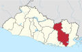
San Luis de la Reina
Location in El Salvador
Coordinates: 13°49′N88°21′W / 13.817°N 88.350°W / 13.817; -88.350
CountryFlag of El Salvador.svg  El Salvador
Department San Miguel Department
Area
  Total64.9 sq mi (168.2 km2)
Elevation
1,729 ft (527 m)
Population
  Total7,500

San Luis de la Reina is a municipality (north of San Miguel) in the San Miguel department of El Salvador.

Coordinates: 13°49′N88°21′W / 13.817°N 88.350°W / 13.817; -88.350


Related Research Articles

USS <i>Bogue</i>

USS Bogue (AVG/ACV/CVE/CVHE-9) was the lead ship in the Bogue class of escort carriers in the United States Navy during World War II. The ship was named for Bogue Sound in North Carolina. She was originally classified AVG-9, but was changed to ACV-9, 20 August 1942; CVE-9, 15 July 1943; and CVHE-9, 12 June 1955. Aircraft operating from Bogue, plus her escorts, sank eleven German and two Japanese submarines, making her the most successful anti-submarine carrier in World War II.

San Miguel, El Salvador City in San Miguel Department, El Salvador

San Miguel is a city in eastern El Salvador. It is the country's third most populous city. It is located 138 km east of the capital, San Salvador. It is also the capital of the department of San Miguel and a municipality. The population of the city in 2017 was 518,410.

San Agustín, Copán Place in Copán, Honduras

San Agustín is a municipality in the Honduran department of Copán. It is situated 36.4 kilometres (22.6 mi) by road northwest of Santa Rosa de Copán.

Chapeltique Municipality in San Miguel Department, El Salvador


Chapeltique is a municipality in the San Miguel department of El Salvador.

Chinameca, San Miguel Place in San Miguel, El Salvador

Chinameca is a municipality in the San Miguel Department of El Salvador. The Chinameca Volcano rises over the town.

Comacarán Municipality in San Miguel Department, El Salvador

Comacarán is a municipality in the San Miguel department of El Salvador.

Lolotique Municipality in San Miguel Department, El Salvador

Lolotique is a municipality in the San Miguel department of El Salvador.

Nuevo Edén de San Juan Municipality in San Miguel Department, El Salvador

Nuevo Edén de San Juan is a municipality in the San Miguel department of El Salvador.

San Gerardo Municipality in San Miguel Department, El Salvador

San Gerardo is a municipality in the San Miguel department of El Salvador.

Uluazapa Municipality in San Miguel Department, El Salvador

Uluazapa is a municipality in the San Miguel department of El Salvador. The town is located approximately 30 minutes from San Miguel and is known for its musical atmosphere. Many refer to it as a "cradle of musicians" for its emphasis on musical education. The name "Uluazapa" stands for "Stony place of the Ulúas" in Nauathl, which were Indian tribes that inhabited the area pre-Columbian time. The municipality is made up of surrounding cantons, hamlets, and neighborhoods. The Uluazapa Central Park is located in the middle of the town, next to the colonial "San Pedro Apostal" church and the municipal hall. Surrounding the park are local shop, restaurants, and businesses. It also has a large sport center equipped with a soccer field and basketball courts. The town has a population of 3,351 Inhabitants.

Sociedad, Morazán Municipality in Morazán Department, El Salvador

Sociedad is a municipality in the Morazán department of El Salvador. It lies between La Unión and San Miguel, both of which are departments of El Salvador.

Gualococti Municipality in Morazán Department, El Salvador

Gualococti is a municipality in the Morazán department of El Salvador.

San Cayetano Istepeque Municipality in San Vicente Department, El Salvador

San Cayetano Istepeque, is a municipality in the San Vicente department of El Salvador. Its altitude is approximately 510 m.

German submarine U-88 was a Type VIIC U-boat of Nazi Germany's Kriegsmarine during World War II.

Onzaga Municipality and town in Santander Department, Colombia

Onzaga is a town and municipality in the Santander Department in northeastern Colombia. Onzaga borders in the north San Joaquín, in the east and south the municipalities Soatá, Covarachía, Tipacoque and Tutazá of the department of Boyacá and in the west with Coromoro. Onzaga is 177 kilometres (110 mi) south of the department capital Bucaramanga. The topography of Onzaga varies greatly; from 900 metres (3,000 ft) to 3,600 metres (11,800 ft).

Berrocalejo Place in Extremadura, Spain

Berrocalejo is a municipality located in the province of Cáceres, Extremadura, Spain. According to the 2005 census (INE), the municipality has a population of 115 inhabitants.

Vegaquemada municipality in Castile and León, Spain

Vegaquemada is a municipality located in the province of León, Castile and León, Spain. According to the 2004 census (INE), the municipality has a population of 488 inhabitants.

Texistepec is a municipality located in the south-east zone in the State of Veracruz, about 285 km from state capital Xalapa. It has a surface of 615.26 km2. It is located at 17°54′N94°49′W. Texistepec in 1580 concerned to Coatzacoalcos's province. In 1831 San Miguel Texistepec was forming a municipality and was possessing 2 square leagues of lands with legal titles, southern people who suffered the batterings of the currents that our Mexican Republic had.

San Miguel is a corregimiento in Balboa District, Panamá Province, Panama with a population of 1,044 as of 2010. It is the seat of Balboa District. Its population as of 1990 was 1,179; its population as of 2000 was 817.

Cathedral Basilica of Queen of Peace, San Miguel Church in San Miguel, El Salvador

The Cathedral Basilica of Queen of Peace, also called San Miguel Cathedral, is a Catholic church located in the city of San Miguel, El Salvador.