Intibucá is one of the 18 departments in the Republic of Honduras. Intibucá covers a total surface area of 1,186.1 square miles (3,072 km2). Its capital is the city of La Esperanza, in the municipality of La Esperanza.

Ahuachapán is a city, and municipality, and the capital of the Ahuachapán Department in western El Salvador. The municipality, including the city, covers an area of 244.84 km² and as of 2007 has a population of 110,511 people. Situated near the Guatemalan border, it is the westernmost city in the country and is the center of an agricultural region producing primarily coffee.

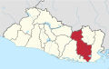
San Miguel is a city in eastern El Salvador. It is the country's third most populous city. It is located 138 km east of the capital, San Salvador. It is also the capital of the department of San Miguel and a municipality. The population of the city in 2017 was 518,410.
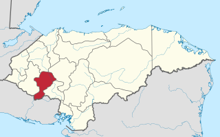
La Virtud is a municipality in the Honduran department of Lempira.
Piraera is one of the municipalities of Lempira department in Honduras. It is located on one of the branches of "Congolón" mountain, it is 105 km away from the city of Gracias.
Alegría is a municipality in the Usulután department of El Salvador.
Berlín is a municipality in the Usulután department of El Salvador.
Estanzuelas is a municipality in the Usulután department of El Salvador.

Chapeltique is a municipality in the San Miguel department of El Salvador.

Chinameca is a municipality in the San Miguel Department of El Salvador. The Chinameca Volcano rises over the town.
Comacarán is a municipality in the San Miguel department of El Salvador.
Nuevo Edén de San Juan is a municipality in the San Miguel department of El Salvador.

San Gerardo is a municipality in the San Miguel department of El Salvador.

Sesori is a municipality in the Department of San Miguel, El Salvador. This is where many of the local people come and get food, supplies, education and it is also here where they get transportation to larger cities. Its location was used by other surrounding villages as people came here to make use of telephone services provided by ANTEL.

Yucuaiquin is a municipality in La Unión Department of El Salvador, located on the slopes of Cerro La Cruz.

Alejandría is a town and municipality in the Antioquia Department, Colombia. Part of the subregion of Eastern Antioquia. Bordered to the north with the municipalities of Concepción, Santo Domingo and San Roque, on the east by the municipality of San Rafael, on the south by the municipalities of San Rafael and Guatapé, and on the west by the municipalities of El Penol and Concepción. Its capital is 90 kilometers from the city of Medellin, the capital of Antioquia department. The municipality has an area of 149 km2.
Agua Caliente is a municipality in the Chalatenango department of El Salvador.

Viterbo is a town and municipality in the Colombian Department of Caldas. Formally constituted as a municipality on December 31, 1951, it was founded on April 19, 1911 by Presbítero Nazario Restrepo Botero. The current mayor is Jhon Mario Giraldo Arrubla. They call it "El Paraiso Turistico de Caldas" (The Touristic Paradise of The Colombian Department of Caldas. It is known as this due to its all year through warm climate, Villas, Farms and Condominiums around the surrounding land, and the welcoming people of the 'Viterbeños'.

Tello is a town and municipality in the Huila Department, Colombia. It is characterized by its extensive plain between the Magdalena River and the foot of the Cordillera Oriental mountain range up to its peaks, and with the Fortalecillas and Villavieja rivers being located nearby. Its territorial extension is 589 km², its altitude is 575 meters( ) above sea level and its climate is warm with an average temperature of 26ºC.
Zumpuhuacán is a municipality in the State of Mexico. Its municipal seat is also called Zumpahuacán: The area was settled by Mexicas in 1220.