
Smart growth is an urban planning and transportation theory that concentrates growth in compact walkable urban centers to avoid sprawl. It also advocates compact, transit-oriented, walkable, bicycle-friendly land use, including neighborhood schools, complete streets, and mixed-use development with a range of housing choices. The term "smart growth" is particularly used in North America. In Europe and particularly the UK, the terms "compact city", "urban densification" or "urban intensification" have often been used to describe similar concepts, which have influenced government planning policies in the UK, the Netherlands and several other European countries.

Zoning is a method of urban planning in which a municipality or other tier of government divides land into areas called zones, each of which has a set of regulations for new development that differs from other zones. Zones may be defined for a single use, they may combine several compatible activities by use, or in the case of form-based zoning, the differing regulations may govern the density, size and shape of allowed buildings whatever their use. The planning rules for each zone determine whether planning permission for a given development may be granted. Zoning may specify a variety of outright and conditional uses of land. It may indicate the size and dimensions of lots that land may be subdivided into, or the form and scale of buildings. These guidelines are set in order to guide urban growth and development.

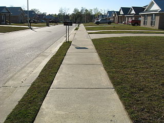
Downtown is a term primarily used in North America by English speakers to refer to a city's sometimes commercial, cultural and often the historical, political and geographic heart. It is often synonymous with its central business district (CBD). Downtowns typically contain a small percentage of a city’s employment. In some metropolitan areas it is marked by a cluster of tall buildings, cultural institutions and the convergence of rail transit and bus lines. In British English, the term "city centre" is most often used instead.

A residential area is a land used in which housing predominates, as opposed to industrial and commercial areas.
Inclusionary zoning (IZ), also known as inclusionary housing, refers to municipal and county planning ordinances that require a given percentage of units in a new housing development be affordable by people with low to moderate incomes. The term inclusionary zoning indicates that these ordinances seek to counter exclusionary zoning practices, which exclude low-cost housing from a municipality through the zoning code. Non-profit affordable housing developers build 100% of their units as affordable, but need significant taxpayer subsidies for this model to work. Inclusionary zoning allows municipalities to have new affordable housing constructed without taxpayer subsidies. In order to encourage for-profit developers to build projects that include affordable units, cities often allow developers to build more total units than their zoning laws currently allow so that there will be enough profit generating market-rate units to offset the losses from the below market-rate units and still allow the project to be financially feasible. Inclusionary zoning can be mandatory or voluntary, though the great majority of units have been built as a result of mandatory programmes. There are variations among the set-aside requirements, affordability levels, and length of time the unit is deed-restricted as affordable housing.
A streetcar suburb is a residential community whose growth and development was strongly shaped by the use of streetcar lines as a primary means of transportation. Such suburbs developed in the United States in the years before the automobile, when the introduction of the electric trolley or streetcar allowed the nation’s burgeoning middle class to move beyond the central city’s borders. Early suburbs were served by horsecars, but by the late 19th century cable cars and electric streetcars, or trams, were used, allowing residences to be built farther away from the urban core of a city. Streetcar suburbs, usually called additions or extensions at the time, were the forerunner of today's suburbs in the United States and Canada. San Francisco's Western Addition is one of the best examples of streetcar suburbs before westward and southward expansion occurred.
Subdivisions are the act of dividing land into pieces that are easier to sell or otherwise develop, usually via a plat. The former single piece as a whole is then known as a subdivision. Subdivisions may be simple, involving only a single seller and buyer, or complex, involving large tracts of land divided into many smaller parcels. If it is used for housing it is typically known as a housing subdivision or housing development, although some developers tend to call these areas communities.

A setback, in the specific sense of a step-back, is a step-like form of a wall or other building frontage, also termed a recession or recessed story. Importantly, one or more step-backs lowers the building's center of mass, making it more stable. A setback as a minimum one-bay indent across all stories is called a recessed bay or recess and is the more common exterior form of an alcove.
A Form-Based Code (FBC) is a means of regulating land development to achieve a specific urban form. Form-Based Codes foster predictable built results and a high-quality public realm by using physical form as the organizing principle, with less focus on land use, through municipal regulations. An FBC is a regulation, not a mere guideline, adopted into city, town, or county law and offers a powerful alternative to conventional zoning regulation.

Mixed use is a type of urban development, urban design, urban planning and/or a zoning classification that blends multiple uses, such as residential, commercial, cultural, institutional, or entertainment, into one space, where those functions are to some degree physically and functionally integrated, and that provides pedestrian connections. Mixed-use development may be applied to a single building, a block or neighborhood, or in zoning policy across an entire city or other administrative unit. These projects may be completed by a private developer, (quasi-) governmental agency, or a combination thereof. A mixed-use development may be a new construction, reuse of an existing building or brownfield site, or a combination.
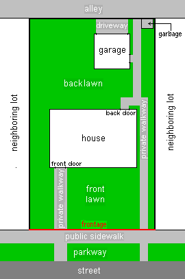
In real estate, a lot or plot is a tract or parcel of land owned or meant to be owned by some owner(s). A plot is essentially considered a parcel of real property in some countries or immovable property in other countries. Possible owner(s) of a plot can be one or more person(s) or another legal entity, such as a company/corporation, organization, government, or trust. A common form of ownership of a plot is called fee simple in some countries.

Secondary suites are self-contained apartments, cottages, or small residential units, that are located on a property that has a separate main, single-family home, duplex, or other residential unit. In some cases, the ADU or in-law is attached to the principal dwelling or is an entirely separate unit, located above a garage or in the backyard on the same property. In British English the term annex or granny annex is used instead. Reasons for wanting to add a secondary suite to a property may be to receive additional income, provide social and personal support to a family member, or obtain greater security.

Car dependency is the concept that some city layouts cause cars to be favoured over alternate forms of transportation, such as bicycles, public transit, and walking.

In the United States, zoning includes various land use laws falling under the police power rights of state governments and local governments to exercise authority over privately owned real property. Zoning laws in major cities originated with the Los Angeles zoning ordinances of 1904 and the New York City 1916 Zoning Resolution. Early zoning regulations were in some cases motivated by racism and classism, particularly with regard to those mandating single-family housing. Zoning ordinances did not allow African-Americans moving into or using residences that were occupied by majority whites due to the fact that their presence would decrease the value of home. The constitutionality of zoning ordinances was upheld by the Supreme Court of the United States in Village of Euclid, Ohio v. Ambler Realty Co. in 1926.
Exclusionary zoning is the use of zoning ordinances to exclude certain types of land uses from a given community, especially to regulate racial and economic diversity. In the United States, exclusionary zoning ordinances are standard in almost all communities. Exclusionary zoning was introduced in the early 1900s, typically to prevent racial and ethnic minorities from moving into middle- and upper-class neighborhoods. Municipalities use zoning to limit the supply of available housing units, such as by prohibiting multi-family residential dwellings or setting minimum lot size requirements. These ordinances raise costs, making it less likely that lower-income groups will move in. Development fees for variance, a building permit, a certificate of occupancy, a filing (legal) cost, special permits and planned-unit development applications for new housing also raise prices to levels inaccessible for lower income people.

A site plan or a plot plan is a type of drawing used by architects, landscape architects, urban planners, and engineers which shows existing and proposed conditions for a given area, typically a parcel of land which is to be modified. Sites plan typically show buildings, roads, sidewalks and paths/trails, parking, drainage facilities, sanitary sewer lines, water lines, lighting, and landscaping and garden elements.
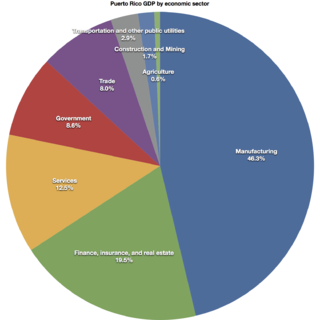
As of 2012, the real estate industry in Puerto Rico constituted about 14.8% of the gross domestic product of Puerto Rico, about 1% of all of the employee compensation on the island and, together with finance and insurance (FIRE), about 3.7% of all the employment on the jurisdiction.

The Committee of 100 on the Federal City, locally referred to as the Committee of 100, is a private, nonprofit membership organization which promotes responsible land use and planning in Washington, D.C., and advocates adherence to the L'Enfant Plan and McMillan Plan as a guide to city growth. It is one of the most influential private land use planning bodies in Washington, D.C.

Missing middle housing is a term which describes a range of multi-family or clustered housing types that are compatible in scale with single-family or transitional neighborhoods. It is usually used to describe a phenomenon in Canada and the United States, and those countries which have sought to replicate their style of urban planning, which lacks this type of medium-density housing due to car dependant suburban sprawl. Missing middle housing is intended to meet the demand for walkable neighborhoods, respond to changing demographics, and provide housing at different price points. The term "missing middle" is meant to describe housing types that were common in the pre-WWII United States such as duplexes, rowhouses, and courtyard apartments but are now less common and, therefore, "missing". Rather than focusing on the number of units in a structure, missing middle housing emphasizes building at a human scale and heights that are appropriate for single-family neighborhoods or transitional neighborhoods. After the introduction of the term in 2010, the concept has been applied in the United States, Canada, and Australia.
Arlington County Board v. Richards, 434 U.S. 5 (1977), is a United States Supreme Court decision on the application of the Equal Protection Clause of the Fourteenth Amendment to the Constitution to municipal parking restrictions. In a unanimous per curiam opinion, the Court held that a residential zoned parking system requiring permits for daytime parking in the Aurora Highlands neighborhood of Arlington County, Virginia, with those permits limited to residents, their guests and those who came to their homes for business purposes had a rational basis and was thus constitutional. Its decision overturned the Virginia Supreme Court.