Related Research Articles

The Stillwater River is a 69.3-mile-long (111.5 km) tributary of the Great Miami River in western Ohio in the United States. Via the Great Miami and Ohio rivers, it is part of the Mississippi River watershed.

The Feather River is the principal tributary of the Sacramento River, in the Sacramento Valley of Northern California. The river's main stem is about 73 miles (117 km) long. Its length to its most distant headwater tributary is just over 210 miles (340 km). The main stem Feather River begins in Lake Oroville, where its four long tributary forks join—the South Fork, Middle Fork, North Fork, and West Branch Feather Rivers. These and other tributaries drain part of the northern Sierra Nevada, and the extreme southern Cascades, as well as a small portion of the Sacramento Valley. The total drainage basin is about 6,200 square miles (16,000 km2), with approximately 3,604 square miles (9,330 km2) above Lake Oroville.

The Mad River is a stream located in the west central part of the U.S. state of Ohio. It flows 66 miles (106 km) from Logan County to downtown Dayton, where it meets the Great Miami River. The stream flows southwest from its source near Campbell Hill through West Liberty, along U.S. Route 68 west of Urbana, past Springfield, then along Ohio State Route 4 into Dayton. The stream's confluence with the Great Miami River is in Deeds Park.
Rattlesnake Creek is a tributary of Paint Creek, 42.3 miles (68.1 km) long, in south-central Ohio in the United States. Via Paint Creek and the Scioto and Ohio Rivers, it is part of the watershed of the Mississippi River, draining an area of 277 square miles (720 km2). According to the Geographic Names Information System, it has also been known historically as "Rattlesnake Fork."
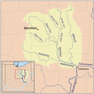
Killbuck Creek is a tributary of the Walhonding River, 81.7 mi (131.5 km) long, in north-central Ohio in the United States. Via the Walhonding, Muskingum and Ohio Rivers, it is part of the watershed of the Mississippi River. It drains an area of 613 mi² (1588 km²).
Loramie Creek is a 40.0-mile-long (64.4 km) tributary of the Great Miami River in western Ohio in the United States. Via the Great Miami and Ohio rivers, it is part of the watershed of the Mississippi River, draining an area of 265 square miles (690 km2). According to the Geographic Names Information System, the stream has also been known historically as "Laramie Creek," "Loramie Ditch," "Loramies Creek," and "Lonamie Creek." It is named after Louis Lorimier, a French-Canadian fur trader who had a trading post in the area in the 18th century.
Wakatomika Creek is a tributary of the Muskingum River, 42.6 mi (68.6 km) long, in central Ohio in the United States. Via the Muskingum and Ohio Rivers, it is part of the watershed of the Mississippi River, draining an area of 234 mi² (606 km²)
Greenville Creek is a 44.4-mile-long (71.5 km) tributary of the Stillwater River in southwestern Ohio in the United States. Via the Stillwater River, the Great Miami River, and the Ohio River, its water flows to the Mississippi River and ultimately the Gulf of Mexico. The creek starts in extreme eastern Indiana in Randolph County. It soon flows into Darke County, Ohio, and joins with a tributary that also starts in Indiana, Dismal Creek. It flows through Greenville and Gettysburg before entering Miami County. Near its confluence with the Stillwater River at Covington it drops 20 feet (6.1 m) at Greenville Falls in a glacially-cut gorge that is a state nature preserve.

Wheeling Creek is a tributary of the Ohio River, 30.2 miles (48.6 km) long, in eastern Ohio in the United States. Via the Ohio River, it is part of the watershed of the Mississippi River, draining an area of 108 square miles (280 km2) on the unglaciated portion of the Allegheny Plateau. It flows for its entire length in Belmont County; its tributaries also drain small areas of south-eastern Harrison County and south-western Jefferson County.
Turtle Creek is a 13.7-mile-long (22.0 km) tributary of the Little Miami River in Turtlecreek Township, Warren County, Ohio, which takes its name from this creek. Turtle Creek is named for Chief Little Turtle, of the Miami Indian Tribe Turtle Creek is a tributary within the Little Miami and Ohio River watersheds.
Raccoon Creek is a 114-mile-long (183 km) stream that drains parts of five Ohio counties in the United States. It originates in Hocking County, Ohio. It flows through Vinton County and Gallia County and a corner of Meigs County. Its largest tributary, Little Raccoon Creek, arises in Jackson County. The watershed also includes part of Athens County, drained by another tributary, Hewett Fork. The other major tributaries are Elk Fork, located entirely in Vinton County, and Brushy Fork, which is mostly in Vinton County with a small area in Hocking County.

Wolf Creek is a 19.8-mile-long (31.9 km) tributary of the Great Miami River in southwestern Ohio in the United States. It rises in western Montgomery County, northwest of Brookville, and flows generally southeast, passing through the center of Trotwood and joining the Great Miami in downtown Dayton.
Little Wapwallopen Creek is a tributary of the Susquehanna River in Luzerne County, Pennsylvania, in the United States. It is approximately 17 miles (27 km) long and flows through Rice Township, Dorrance Township, Conyngham Township, and Hollenback Township. The watershed of the creek has an area of 39.5 square miles (102 km2). The creek is designated as a Coldwater Fishery and a Migratory Fishery and is not considered to be impaired. It has two named tributaries: Pond Creek and Nuangola Outlet. Wild trout naturally reproduce in the creek.

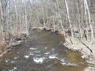
Paint Creek is a stream in Preble County, Ohio, in the United States. It is a tributary of Sevenmile Creek.
Periwinkle Run is a stream in Preble County, Ohio, in the United States. Periwinkle Run was named for the freshwater snail shells collected there which the early settlers called periwinkles.
Four Mile Creek is a stream in Preble County and Butler County, Ohio, in the United States.
Beasley Run is a stream in the U.S. state of Ohio. The 3.6-mile (5.8 km) long stream is a tributary of Sevenmile Creek.
Twin Creek is a stream in the U.S. state of Ohio. The 46.2-mile (74.4 km) long stream is a tributary of Great Miami River. Lesley Run is a tributary of Twin Creek.

Mill Creek is a stream in central Ohio. It is a tributary of the Scioto River.

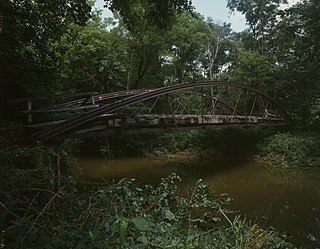
The Roberts Covered Bridge is a Burr Truss covered bridge in Preble County, Ohio near Eaton. It was built in 1829, and was listed on the National Register of Historic Places in 1971.
References
- ↑ U.S. Geological Survey Geographic Names Information System: Sevenmile Creek (Ohio)
- ↑ Lowry, Robert Eaton (1915). History of Preble County, Ohio: Her People, Industries and Institutions. B.F. Bowen. p. 124.
- ↑ Jones, Richard (March 29, 2013). "Flood ravaged some small towns, left others alone". Journal-News. Retrieved 24 December 2015.
- ↑ Coordinates derived visually from Acme Maps topographical map. Position of origin on GNIS appears to be incorrect: 39°30′00″N84°35′25″W / 39.5000554°N 84.5902264°W
- ↑ United States Environmental Protection Agency. "Watershed Report: Sevenmile Creek". watersgeo.epa.gov. Archived from the original on 2020-08-26. Retrieved 2020-08-26.
- ↑ "USGS Surface-Water Annual Statistics for Ohio: USGS 03273000 Sevenmile Creek at Sevenmile OH". waterdata.usgs.gov. Archived from the original on 2020-08-26. Retrieved 2020-08-26.
| | This Butler County, Ohio state location article is a stub. You can help Wikipedia by expanding it. |
| | This Preble County, Ohio state location article is a stub. You can help Wikipedia by expanding it. |
| | This article related to a river in Ohio is a stub. You can help Wikipedia by expanding it. |