Set up in the Middle Kingdom under Senusret III, Shalfak is one of a chain of 17 forts which the pharaohs of the 12th Dynasty established to secure their southern frontier during a time when they sought to expand Egypt's influence. Shalfak, along with the forts of Buhen, Mirgissa, Uronarti, Askut, Dabenarti, Semna, and Kumma, were established within signalling distance of each other.[2]
Description
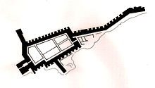
Situation plan of Shalfak
The fortress occupies a roughly triangular area of about 1,800 square metres (0.44 acres), adapted to the available ground. Its massive mudbrick wall still stands up to 6 metres (20ft) high and 8 metres (26ft) thick. Three spur walls, towards the north, west and east, complete the fortification system. The eastern wall protects a stairway leading down to the river to ensure access to a water supply in the case of siege.[3] The internal structures are very well preserved, including a command building, barracks, workshops, storerooms and a granary arranged in a grid plan.[4]
This page is based on this Wikipedia article Text is available under the CC BY-SA 4.0 license; additional terms may apply. Images, videos and audio are available under their respective licenses.