Mirgissa

Last updated
Mirgissa in hieroglyphs
MirgissaMirgissaMirgissa
Mirgissa
Mirgissa

Iqen
Jqn
Mirgissa, the ancient Egyptian Fortress in Wadi Halfa territory, before it drowned because of the Egyptian high dam Mirgissa Fortress.jpg
Mirgissa, the ancient Egyptian Fortress in Wadi Halfa territory, before it drowned because of the Egyptian high dam
Map of Mirgissa Mirgissa-plan.jpg
Map of Mirgissa

Mirgissa (originally Iken) was a settlement in Northern state, Sudan. Situated at the 2nd cataract in Wadi Halfa, it contained one of the largest fortresses in Nubia. In the time of Thutmose II, 250 to 450 people inhabited the area. [1] The first European explorer was English geologist Sir Henry George Lyons in 1892, and was excavated without Sudanese permission, by the French Egyptologist Jean Vercoutter from 1962 to 1969. In addition to the fort, excavations uncovered the remains of two cities, one of which was fortified, a northern enclosure, two cemeteries, a boat slide, and a port. Construction of the Aswan High Dam caused the disappearance of Mirgissa, which now lies under the waters of Lake Nubia.

Contents

Geography

View of the plain to the northeast. Mirgissa-fort-Pl.3.jpg
View of the plain to the northeast.

Travelers from the north who reached Abusir had to leave their boats and circumvent the 2nd cataract in order to reach Mirgissa. It was situated 300 feet (91 m) from the harbor, where boats from the south could dock in calm waters, the rapids of the cataract preventing them from continuing their journey further north. [2] Its lofty geographic position allowed sentries to observe the movement of troops for miles around. [3]

History

Even before the great fort, an open town existed at Mirgissa. [4] It went on to become a frontier post and trade center; it also served as a river control point at the 2nd cataract. [5] The occupation of the region dates back to 7500 BCE as shown by the evidence obtained at Akha, an important Mesolithic site located a few hundred meters east of the great fortress. Large stone tools, dating from 3500 BCE, were found in several places of the plain. They demonstrate that Mirgissa was occupied in Neolithic times. But the occupation was at its height during the Middle Kingdom and Second Intermediate Period of ancient Egypt, and to a lesser extent, during the New Kingdom.

Perspective reconstruction of Mirgissa Mirgissa2-ombre-couleurs2.jpg
Perspective reconstruction of Mirgissa

While Senusret I probably established the fortification site within the northern enclosure, the great fortress was mainly the work of Senusret III. A stele, dated to year 8 of the reign of Senusret III, was discovered near the fortress of Semna. Its inscription stresses the economic importance of Mirgissa. Its translation reads:

"The southern frontier made in regnal year 8 under the majesty of the King of Upper and Lower Egypt Khakaure (may he live for ever and ever) in order to prevent it being passed by an Nubian journeying north by land or in a kai-boat as well as any livestock belonging to Nubians, with the exception of a Nubian who shall come to traffic at Mirgissa or on an embassy, or on any matter which may lawfully be done with them; but it shall be forbidden for any kai-boat of the Nubians to pass northwards beyond Semna for ever." [6]

During the Twelfth Dynasty, it served as a customs post for travels heading north to Egypt. [5] The periods of most intense occupation date from the Thirteenth Dynasty and then the Hyksos era, as evidenced by the large number of beetles found on the premises. The great fortress was then re-occupied during the Eighteenth Dynasty, followed by a sharp decline until the Twentieth Dynasty. Sporadically occupied at the time Meroitic era, the abandonment of the site was final during the early Christian era.

House surrounded by a corrugated wall. Mirgissa-fort-Pl.9.jpg
House surrounded by a corrugated wall.
City

Mirgissa's open city predates its fortification. [4] Situated 1 kilometre (0.62 mi) north-northeast of the great fortress, it stretched over a 75,000 square metres (810,000 sq ft) area. In its early development, the city was protected by a stone wall 1 metre (3 ft 3 in) thick, though the residential area later spread outside the walled section. According to various artifacts unearthed at the site, such as jars, millstones, bread molds, beer mugs, and plates, the city appeared to have been occupied by a strictly Egyptian population during the Middle Empire and the Second Intermediate Period. Of the two older excavated houses, the first was surrounded by a rectangular corrugated brick wall, while the second, a stone hut, was mainly rectangular though it contained circular elements.

Cemeteries

The multiple cemeteries at Mirgissa establish a continuous settlement here from the late Middle Kingdom through the New Kingdom: [7]

Fortress

The great fort's wall and towers are examples of Ancient Egyptian architecture. Mirgissa-fort-Pl.8.jpg
The great fort's wall and towers are examples of Ancient Egyptian architecture.
Narrow passage by the north gate of the great fortress. Mirgissa-fort-Pl.5.jpg
Narrow passage by the north gate of the great fortress.

The great fortress dominated the western Wadi. It was built by the pharaohs of the Middle Kingdom to defend their southern border and control trade routes that passed through the Nile from Sudan and Africa. From a strategic and commercial standpoint, Mirgissa was of importance as it ensured economic exchanges between the Kingdom of Kush and Egypt. Together with Dabenarti, situated on a rocky islet measuring 2.5 square kilometres (0.97 sq mi), [8] the two fortresses formed a barrier to prevent invasions from the south. During excavations, only the foundation remained of the smaller Dabenarti fort, dating from the Twelfth Dynasty, its purpose having been to protect the harbor and dock located at the southern end of The Boat Slide. The great fortress was abandoned during the reign of Neferhotep I. [9]

While eleven forts were built during the reign of Senusret III in the region between the 2nd and 3rd cataracts, including Shalfak, Uronarti, Askut, Semna, Kumma, and Sumna South, [10] Mirgissa was the largest of them. [11] The great fortress covered more than 40,000 square metres (430,000 sq ft). Its double wall with bastions and square-cornered towers, 12 metres (39 ft) high, protected the city. The walls were more than 6 metres (20 ft) thick and over 10 metres (33 ft) high. Both entrances were protected by a ditch. The south side, facing the Nile, was protected by a fortified wall, which perfectly fit the rocky peaks on which it was underpinned. Two enormous gates were flanked to the north and near the southeast corner of the river. The north gate had a narrow passage, its access blocked by two massive wooden doors and a portcullis. Angled bedding-planes enabled the uphill brickwork. [4] Excavations revealed a small temple dedicated to the goddess Hathor and a stele mentioning this goddess as the mistress of Iken; this discovery enabled positive identification of the fortress.

Port and boat slide

Boat slide Mirgissa-fort-p.206.jpg
Boat slide

During excavations, few traces of the port were evident, probably due to an exceptional flood. However, the French expedition identified the remains of a boat slipway, [12] over 2 kilometres (1.2 mi) in length. It extended to the natural harbor in the south. It served as a slide for hauling boats who wanted to pass the 2nd cataract. Composed of evenly spaced wooden cross beams set in silt and spread mud layers, it was low enough to wet the clay and make it very slippery, thus reducing friction between the boat hull and the track.

Archaeological finds

The expedition of Jean Vercoutter made a discovery in the surrounding desert, west and not far from the city open, of a grave filled with some 3,500 fragments of pottery sherds; some were inscribed. The Execration texts listed the names of foreign countries and their leaders, their purpose apparently being a form of ritual magic designed to curse the enemies of Egypt. [13] It is highly likely that once the text was written on a vase, it was broken and its fragments buried in the grave. Near this place, three statues dating from the Twelfth Dynasty were also unearthed, as well as a seal from Nebiryraw I of the Sixteenth Dynasty. [9]

See also

Related Research Articles

<span class="mw-page-title-main">Amenemhat III</span> Egyptian pharaoh

Amenemhat III, also known as Amenemhet III, was a pharaoh of ancient Egypt and the sixth king of the Twelfth Dynasty of the Middle Kingdom. He was elevated to throne as co-regent by his father Senusret III, with whom he shared the throne as the active king for twenty years. During his reign, Egypt attained its cultural and economic zenith of the Middle Kingdom.

<span class="mw-page-title-main">Middle Kingdom of Egypt</span> Reunified ancient Egypt c. 2000-1700 BC

The Middle Kingdom of Egypt is the period in the history of ancient Egypt following a period of political division known as the First Intermediate Period. The Middle Kingdom lasted from approximately 2040 to 1782 BC, stretching from the reunification of Egypt under the reign of Mentuhotep II in the Eleventh Dynasty to the end of the Twelfth Dynasty. The kings of the Eleventh Dynasty ruled from Thebes and the kings of the Twelfth Dynasty ruled from el-Lisht.

<span class="mw-page-title-main">Elephantine</span> Island in the Nile

Elephantine is an island on the Nile, forming part of the city of Aswan in Upper Egypt. The archaeological sites on the island were inscribed on the UNESCO World Heritage List in 1979 along with other examples of Upper Egyptian architecture, as part of the "Nubian Monuments from Abu Simbel to Philae".

<span class="mw-page-title-main">Thutmose I</span> Egyptian pharaoh

Thutmose I was the third pharaoh of the 18th Dynasty of Egypt. He received the throne after the death of the previous king, Amenhotep I. During his reign, he campaigned deep into the Levant and Nubia, pushing the borders of Egypt farther than ever before in each region. He also built many temples in Egypt, and a tomb for himself in the Valley of the Kings; he is the first king confirmed to have done this.

<span class="mw-page-title-main">Twelfth Dynasty of Egypt</span> Egyptian Middle Kingdom dynasty from 1991 to 1802 BCE

The Twelfth Dynasty of ancient Egypt is considered to be the apex of the Middle Kingdom by Egyptologists. It often is combined with the Eleventh, Thirteenth, and Fourteenth dynasties under the group title, Middle Kingdom. Some scholars only consider the 11th and 12th dynasties to be part of the Middle Kingdom.

The Philae temple complex is an island-based temple complex in the reservoir of the Aswan Low Dam, downstream of the Aswan Dam and Lake Nasser, Egypt.

<span class="mw-page-title-main">Senusret III</span> 12th dynasty pharaoh of Ancient Egypt

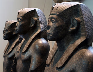
Khakaure Senusret III was a pharaoh of Egypt. He ruled from 1878 BC to 1839 BC during a time of great power and prosperity, and was the fifth king of the Twelfth Dynasty of the Middle Kingdom. He was a great pharaoh of the Twelfth Dynasty and is considered to be, perhaps, the most powerful Egyptian ruler of the dynasty. Consequently, he is regarded as one of the sources for the legend about Sesostris. His military campaigns gave rise to an era of peace and economic prosperity that reduced the power of regional rulers and led to a revival in craftwork, trade, and urban development. Senusret III was among the few Egyptian kings who were deified and honored with a cult during their own lifetime.

<span class="mw-page-title-main">Neferhotep I</span> Egyptian pharaoh

Khasekhemre Neferhotep I was an Egyptian pharaoh of the mid Thirteenth Dynasty ruling in the second half of the 18th century BC during a time referred to as the late Middle Kingdom or early Second Intermediate Period, depending on the scholar. One of the best attested rulers of the 13th Dynasty, Neferhotep I reigned for 11 years.

<span class="mw-page-title-main">Buhen</span> Ancient Egyptian fortress

Buhen was an ancient Egyptian settlement situated on the West bank of the Nile below the Second Cataract in what is now Northern State, Sudan.

<span class="mw-page-title-main">National Museum of Sudan</span> Museum for the history of Sudan

The National Museum of Sudan or Sudan National Museum, abbreviated SNM, is a two-story building constructed in 1955 and established as a museum in 1971.

<span class="mw-page-title-main">Semna (Nubia)</span>

The region of Semna is 15 miles south of Wadi Halfa and is situated where rocks cross the Nile narrowing its flow—the Semna Cataract.

<span class="mw-page-title-main">Uronarti</span>

Uronarti, a Nubian word meaning "Island of the King", is an island in the Nile just south of the Second Cataract in the north of Sudan. The primary importance of the island lies in the massive ancient fortress that still stands on its northern end. This fortress is one of a number constructed along the Nile in Lower Nubia during the Middle Kingdom, primarily by the rulers Senusret I and Senusret III.

<span class="mw-page-title-main">Nubia</span> Region in northern Sudan and southern Egypt

Nubia is a region along the Nile river encompassing the area between the first cataract of the Nile and the confluence of the Blue and White Niles, or more strictly, Al Dabbah. It was the seat of one of the earliest civilizations of ancient Africa, the Kerma culture, which lasted from around 2500 BC until its conquest by the New Kingdom of Egypt under Pharaoh Thutmose I around 1500 BC, whose heirs ruled most of Nubia for the next 400 years. Nubia was home to several empires, most prominently the Kingdom of Kush, which conquered Egypt in the eighth century BC during the reign of Piye and ruled the country as its 25th Dynasty.

<span class="mw-page-title-main">Kingdom of Kush</span> c. 1070 BCE – c. 550 AD kingdom in Nubia, northeast Africa

The Kingdom of Kush was an ancient kingdom in Nubia, centered along the Nile Valley in what is now northern Sudan and southern Egypt.

<span class="mw-page-title-main">Ta-Seti</span> Administrative division of Upper Egypt

Ta-Seti was the first nome of Upper Egypt, one of 42 nomoi in Ancient Egypt. Ta-Seti marked the border area towards Nubia, and the name was also used to refer to Nubia itself.

<span class="mw-page-title-main">Nehesy</span>

Nehesy Aasehre (Nehesi) was a ruler of Lower Egypt during the fragmented Second Intermediate Period. He is placed by most scholars into the early 14th Dynasty, as either the second or the sixth pharaoh of this dynasty. As such he is considered to have reigned for a short time c. 1705 BC and would have ruled from Avaris over the eastern Nile Delta. Recent evidence makes it possible that a second person with this name, a son of a Hyksos king, lived at a slightly later time during the late 15th Dynasty c. 1580 BC. It is possible that most of the artefacts attributed to the king Nehesy mentioned in the Turin canon, in fact belong to this Hyksos prince.

Dabenarti is an island in Sudan, situated in the middle of the Nile near the 2nd cataract. It is close to Mirgissa, 900 metres (3,000 ft) from its east wall, and about 5 kilometres (3.1 mi) south of the Buhen fortress. A fortress on the island was attributed to the Egyptian Nubian period. Construction began during the reign of Senusret I, around 1900 BC, and was completed under Senusret III. Landing at the island fort, measuring 60 by 230 metres in size, was difficult, and it was never completed. With the collapse of Egyptian power at the end of the Middle Kingdom, Dabenarti was abandoned around 1700 BC. It was examined in 1916 by Somers Clarke.

<span class="mw-page-title-main">Shalfak</span>

Shalfak is an ancient Egyptian fortress once built up on the western shore of the Second Cataract of the Nile River and now an island in the Lake Nubia in the north of Sudan. Set up in the Middle Kingdom under Senusret III, it is one of a chain of 17 forts which the pharaohs of the 12th Dynasty established to secure their southern frontier during a time where the Egyptian influence was sought out to be expanded. That is why Shalfak, along with the forts of Buhen, Mirgissa, Uronarti, Askut, Dabenarti, Semna, and Kumma, was established within signalling distance of each other.

The Semna Despatches are a group of papyri that deals with observations of people in and around the forts of the Semna gorge. The fortresses were positioned at Semna because of the expansion of Egypt into Lower Nubia by Senusret III, and were a means of protecting and controlling access into Egypt. The Semna Despaches record the movements of people around the Semna Gorge, and reports their activity's back to an unnamed official in Thebes. Many of the Despatches deal with people who had come to the forts to trade with the Egyptians while others talk about patrols that had gone out and found people in the surrounding desert. The Semna Despatches provides the bulk of information that pertains to the administrative functions of the forts around the Semna Gorge.

References

  1. Janssen, Jozef M. A. (1979). Annual Egyptological Bibliography 1979. Brill Archive. pp. 231–. ISBN   978-90-04-05874-3 . Retrieved 12 August 2012.
  2. Vercoutter (1970), pp. 4-5
  3. Vercoutter (1970), pp. 6-7
  4. 1 2 3 Nicholson, Paul T.; Shaw, Ian (23 March 2000). Ancient Egyptian Materials and Technology. Cambridge University Press. pp. 98, 139–. ISBN   978-0-521-45257-1 . Retrieved 14 August 2012.
  5. 1 2 Lobban, Richard (2004). Historical Dictionary of Ancient and Medieval Nubia. Scarecrow Press. pp. 188, 266–. ISBN   978-0-8108-4784-2 . Retrieved 14 August 2012.
  6. Shaw, Ian (19 February 2004). The Oxford History of Ancient Egypt . Oxford University Press. pp.  368–. ISBN   978-0-19-280458-7 . Retrieved 15 August 2012.
  7. Ben-Tor, Daphna (2007). Scarabs, Chronology, and Interconnections: Egypt and Palestine in the Second Intermediate Period. Saint-Paul. pp. 56–. ISBN   978-3-7278-1593-5 . Retrieved 14 August 2012.
  8. Vercoutter (1970), p. 18
  9. 1 2 Ryholt, K. S. B.; Bülow-Jacobsen, Adam (1997). The Political Situation in Egypt During the Second Intermediate Period, C. 1800-1550 B.C. Museum Tusculanum Press. pp. 162, 344–. ISBN   978-87-7289-421-8 . Retrieved 14 August 2012.
  10. Darnell, John Coleman; Manassa, Colleen (2007). Tutankhamun's Armies: Battle and Conquest during Ancient Egypt's Late 18th Dynasty. Hoboken: John Wiley & Sons. pp. 95–. ISBN   9780471743583 . Retrieved 15 August 2012.
  11. Shaw, Ian; Jameson, Robert (14 May 2002). A Dictionary of Archaeology. John Wiley & Sons. pp. 401–. ISBN   978-0-631-23583-5 . Retrieved 15 August 2012.
  12. Nicholson (2000), p. vii
  13. Hamblin, W. J. (12 April 2006). Warfare in Ancient Near East. Taylor & Francis. pp. 283–. ISBN   978-0-415-25588-2 . Retrieved 15 August 2012.
Bibliography

Coordinates: 21°29′N30°58′E / 21.48°N 30.97°E / 21.48; 30.97