Sharbot Lake

Last updated
Sharbot Lake
Suburban Community
Unincorporated area
Sharbot Lake ON.JPG
Canada Southern Ontario location map 2.png
Red pog.svg
Sharbot Lake
Location in southern Ontario
Coordinates: 44°46′26″N76°41′14″W / 44.77389°N 76.68722°W / 44.77389; -76.68722 Coordinates: 44°46′26″N76°41′14″W / 44.77389°N 76.68722°W / 44.77389; -76.68722 [1]
Country Canada
Province Ontario
County Frontenac
Municipality Central Frontenac
Elevation
[2]
195 m (640 ft)
Time zone UTC-5 (Eastern Time Zone)
  Summer (DST) UTC-4 (Eastern Time Zone)
Postal Code
Area code(s) 613, 343
Website https://www.sharbotlake.com/

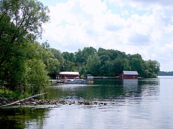
Sharbot Lake is a suburban community and unincorporated area in the municipality of Central Frontenac, Frontenac County in Eastern Ontario, Canada. [1] Named after the Sharbot family, who were local residents, it appeared in Lovell's Gazetteer in 1874. [3] It is part of the Land O'Lakes Tourist Region and is located on the eponymous Sharbot Lake.

Contents

Recreation

The community is surrounded by many lakes that are used for outdoor recreation. The nearby Sharbot Lake Provincial Park has hiking trails, camp sites, and a boat launch into Sharbot Lake. [4]

Local services

Sharbot Lake has tourist-oriented shops and accommodations. Also in the village are a public beach and park, a pharmacy, grocery, bank, medical clinic, law office, real estate services, and public library (part of the Kingston Frontenac Public Library system). The local post office services the village with lock boxes, and rural routes (RR2 Sharbot Lake, RR1 Clarendon Station and RR1 Ompah).

Transportation

Sharbot Lake is accessible via Ontario Highway 38 and Ontario Highway 7 (the latter part of the Trans-Canada Highway in the area). It was once an important stop on the Kingston and Pembroke Railway, the rail bed of which has become the multi-use K&P Rail Trail and part of the Trans Canada Trail.

Annual events

Sharbot Lake hosts:

Olympic gold medalist Simon Whitfield got his start in the triathlon by participating in Sharbot Lake's annual "Kids Of Steel" event for youth.

Related Research Articles

King's Highway 33, commonly referred to as Highway 33 or Loyalist Parkway, is a provincially maintained highway in the Canadian province of Ontario. The route begins at Highway 62 in Bloomfield and travels east to the Collins Bay Road junction at Collins Bay in the city of Kingston, a distance of 60.9 kilometres (37.8 mi). The highway continues farther east into Kingston as Bath Road, ending at the former Highway 2, now Princess Street. Highway 33 is divided into two sections by the Bay of Quinte. The Glenora Ferry service crosses between the two sections just east of Picton, transporting vehicles and pedestrians for free throughout the year.

Kawartha Lakes City in Ontario, Canada

The City of Kawartha Lakes is a unitary municipality in Central Ontario, Canada. It is a municipality legally structured as a single-tier city; however, Kawartha Lakes is the size of a typical Ontario county and is mostly rural. It is the second largest single-tier municipality in Ontario by land area.

Sydenham, Frontenac County, Ontario Place in Ontario, Canada

Sydenham, named after Lord Sydenham, is a community in Frontenac County, located in the municipality of South Frontenac. It is situated at the west end of Sydenham Lake and located north of Kingston, Ontario, Canada.

Central Frontenac Township in Ontario, Canada

Central Frontenac is a township in eastern Ontario, Canada in the County of Frontenac.

Frontenac County County in Ontario, Canada

Frontenac County is a county and census division of the Canadian province of Ontario. It is located in the eastern portion of Southern Ontario. The city of Kingston is in the Frontenac census division, but is separated from the County of Frontenac.

Fall River (Ontario)

The Fall River is a river in Frontenac and Lanark Counties in Eastern Ontario, Canada. It is part of the Ottawa River drainage basin, and flows from Sharbot Lake and through Bennett Lake to join the Mississippi River. The river is named after settlers of the late 17th century.

Kaladar Compact rural communityUnincorporated area in Ontario, Canada

Kaladar is a compact rural community and unincorporated area in the municipality of Addington Highlands, Lennox and Addington County in Eastern Ontario, Canada. It is located at the junction of Ontario Highway 7 and Ontario Highway 41.

Portland, Ontario Police Village in Ontario, Canada

Portland is a police village and unincorporated place located in the municipal township of Rideau Lakes, United Counties of Leeds and Grenville in eastern Ontario, Canada. The community is on Ontario Highway 15 about 60 kilometres (37 mi) northeast of Ontario Highway 401 at Kingston by road, and is situated in geographic Bastard Township on the southeast side of Big Rideau Lake.

Secondary Highway 599, commonly referred to as Highway 599, is a provincially maintained secondary highway in the Canadian province of Ontario. The 291.0 km (180.8 mi) route connects Highway 17 near Ignace with the remote northern community of Pickle Lake; its terminus at Pickle Lake marks the northernmost point on the provincial highway system. Highway 599 was first assigned in 1956 between Savant Lake and Pickle Lake, although it did not connect with the rest of the provincial highway system at the time. Construction to link it with Highway 17 in Ignace took place between 1958 and 1966. The northern end of Highway 599 is one of two possible starting points for a road to the Ring of Fire mineral deposits, the other being Highway 584 in Nakina.

King's Highway 15, commonly referred to as Highway 15, is a provincially maintained highway in the Canadian province of Ontario. It travels north from an interchange with Highway 401 in Kingston to Highway 7 in Carleton Place, a distance of 114.7 kilometres (71.3 mi). In addition to Kingston and Carleton Place, the highway provides access to the Eastern Ontario communities of Joyceville, Seeley's Bay, Morton, Elgin, Crosby, Portland, Lombardy and Franktown. Prior to 1998, Highway 15 continued north from Carleton Place, passed Almonte and through Pakenham, to Highway 17 in Arnprior.

Kingston and Pembroke Railway Former railway in eastern Ontario, Canada

The Kingston and Pembroke Railway (K&P) was a Canadian railway that operated in eastern Ontario. The railway was seen as a business opportunity which would support the lumber and mining industries, as well as the agricultural economy in eastern Ontario.

K&P Rail Trail

The K&P Trail is a recreational trail that runs along the old Kingston and Pembroke Railway (K&P) bed in Ontario, Canada. The K&P was abandoned by its owner, Canadian Pacific Railway, between 1962 and 1986, and ran from Kingston to Renfrew.

King's Highway 38, commonly referred to as Highway 38, was a provincially maintained highway in the Canadian province of Ontario. The 66.9-kilometre (41.6 mi) road connected Highway 2 and Highway 401 in Kingston with Highway 7 west of Perth. It was designated in 1934 and remained relatively unchanged throughout its existence, aside from some minor diversions and a rerouting through Kingston as a result of the construction of Highway 401 in the mid-1950s. At the beginning of 1998, the entire highway was transferred to the municipalities of Frontenac County through which it travelled: Kingston, South Frontenac and Central Frontenac. Today the former highway is named Road 38 and Gardiners Road, but is still referred to as Highway 38 by locals.

Sharbot Lake Provincial Park

Sharbot Lake Provincial Park is a park under the auspices of Ontario Parks in the municipality of Central Frontenac, Frontenac County in Eastern Ontario, Canada. The park has an area of 80 hectares and was established in 1958.

King's Highway 96, commonly referred to as Highway 96, was a provincially maintained highway in the Canadian province of Ontario on Wolfe Island and the main street of Marysville, the island's main village. Together with Highway 95, the routes were the only King's Highway not connected to the rest of the network by a fixed link. Today it is under the jurisdiction of Frontenac Islands Township as Frontenac County does not have a county road system.

Bobs Lake (South Frontenac)

Bobs Lake is a lake in Frontenac County and Lanark County in Eastern Ontario, Canada. It is in the St. Lawrence River drainage basin and is the source of the Tay River.

Black Lake (Central Frontenac)

Black Lake is a lake in the municipality of Central Frontenac, Frontenac County in Eastern Ontario, Canada. It is part of the Saint Lawrence River drainage basin.

Sharbot Lake (Ontario)

Sharbot Lake is a lake in the municipality of Central Frontenac, Frontenac County in Eastern Ontario, Canada. It is part of the Saint Lawrence River drainage basin. The eponymous community of Sharbot Lake is located at the centre of the north shore of the lake.

Silver Lake (Lanark–Frontenac)

Silver Lake is a lake in Tay Valley, Lanark County, and Central Frontenac, Frontenac County, in Eastern Ontario, Canada. It is the source of Silver Lake Creek and is in the Ottawa River drainage basin.

Millhaven Creek

Millhaven Creek is a stream in the municipalities of Loyalist, Lennox and Addington County, and South Frontenac, Frontenac County, and the single-tier municipality of Kingston in eastern Ontario, Canada. It is a tributary of Lake Ontario and is under the auspices of the Cataraqui Region Conservation Authority.

References

  1. 1 2 "Sharbot Lake". Geographical Names Data Base . Natural Resources Canada . Retrieved 2014-08-08.
  2. Taken from Google Earth at geographic coordinates, accessed 2014-08-08.
  3. Hamilton, William (1978). The Macmillan Book of Canadian Place Names. Toronto: Macmillan. p. 171. ISBN   0-7715-9754-1.
  4. "Facilities & Services". Sharbot Lake. Queen's Printer for Ontario, 2011. April 5, 2011. Archived from the original on 17 July 2013. Retrieved 16 January 2012.

Other map sources: