
Erosion is the action of surface processes that removes soil, rock, or dissolved material from one location on the Earth's crust and then transports it to another location where it is deposited. Erosion is distinct from weathering which involves no movement. Removal of rock or soil as clastic sediment is referred to as physical or mechanical erosion; this contrasts with chemical erosion, where soil or rock material is removed from an area by dissolution. Eroded sediment or solutes may be transported just a few millimetres, or for thousands of kilometres.

In geography, a plain, commonly known as flatland, is a flat expanse of land that generally does not change much in elevation, and is primarily treeless. Plains occur as lowlands along valleys or at the base of mountains, as coastal plains, and as plateaus or uplands. Plains are one of the major landforms on earth, being present on all continents and covering more than one-third of the world's land area. Plains in many areas are important for agriculture. There are various types of plains and biomes on them.
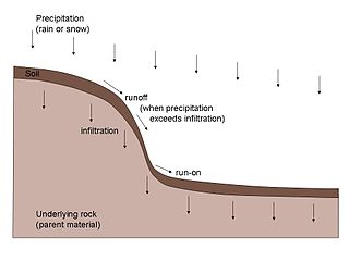
Soil erosion is the denudation or wearing away of the upper layer of soil. It is a form of soil degradation. This natural process is caused by the dynamic activity of erosive agents, that is, water, ice (glaciers), snow, air (wind), plants, and animals. In accordance with these agents, erosion is sometimes divided into water erosion, glacial erosion, snow erosion, wind (aeolian) erosion, zoogenic erosion and anthropogenic erosion such as tillage erosion. Soil erosion may be a slow process that continues relatively unnoticed, or it may occur at an alarming rate causing a serious loss of topsoil. The loss of soil from farmland may be reflected in reduced crop production potential, lower surface water quality and damaged drainage networks. Soil erosion could also cause sinkholes.

Geomorphology is the scientific study of the origin and evolution of topographic and bathymetric features generated by physical, chemical or biological processes operating at or near Earth's surface. Geomorphologists seek to understand why landscapes look the way they do, to understand landform and terrain history and dynamics and to predict changes through a combination of field observations, physical experiments and numerical modeling. Geomorphologists work within disciplines such as physical geography, geology, geodesy, engineering geology, archaeology, climatology, and geotechnical engineering. This broad base of interests contributes to many research styles and interests within the field.

A flash flood is a rapid flooding of low-lying areas: washes, rivers, dry lakes and depressions. It may be caused by heavy rain associated with a severe thunderstorm, hurricane, or tropical storm, or by meltwater from ice or snow flowing over ice sheets or snowfields. Flash floods may also occur after the collapse of a natural ice or debris dam, or a human structure such as a man-made dam, as occurred before the Johnstown Flood of 1889. Flash floods are distinguished from regular floods by having a timescale of fewer than six hours between rainfall and the onset of flooding.

In geography and geology, fluvial sediment processes or fluvial sediment transport are associated with rivers and streams and the deposits and landforms created by sediments. It can result in the formation of ripples and dunes, in fractal-shaped patterns of erosion, in complex patterns of natural river systems, and in the development of floodplains and the occurrence of flash floods. Sediment moved by water can be larger than sediment moved by air because water has both a higher density and viscosity. In typical rivers the largest carried sediment is of sand and gravel size, but larger floods can carry cobbles and even boulders. When the stream or rivers are associated with glaciers, ice sheets, or ice caps, the term glaciofluvial or fluvioglacial is used, as in periglacial flows and glacial lake outburst floods. Fluvial sediment processes include the motion of sediment and erosion or deposition on the river bed.

A gully is a landform created by running water, mass movement, or commonly a combination of both eroding sharply into soil or other relatively erodible material, typically on a hillside or in river floodplains or terraces. Gullies resemble large ditches or small valleys, but are metres to tens of metres in depth and width, are characterized by a distinct 'headscarp' or 'headwall' and progress by headward erosion. Gullies are commonly related to intermittent or ephemeral water flow, usually associated with localised intense or protracted rainfall events or snowmelt. Gullies can be formed and accelerated by cultivation practices on hillslopes in farmland, and they can develop rapidly in rangelands from existing natural erosion forms subject to vegetative cover removal and livestock activity.

Aeolian processes, also spelled eolian, pertain to wind activity in the study of geology and weather and specifically to the wind's ability to shape the surface of the Earth. Winds may erode, transport, and deposit materials and are effective agents in regions with sparse vegetation, a lack of soil moisture and a large supply of unconsolidated sediments. Although water is a much more powerful eroding force than wind, aeolian processes are important in arid environments such as deserts.
Mass wasting, also known as mass movement, is a general term for the movement of rock or soil down slopes under the force of gravity. It differs from other processes of erosion in that the debris transported by mass wasting is not entrained in a moving medium, such as water, wind, or ice. Types of mass wasting include creep, solifluction, rockfalls, debris flows, and landslides, each with its own characteristic features, and taking place over timescales from seconds to hundreds of years. Mass wasting occurs on both terrestrial and submarine slopes, and has been observed on Earth, Mars, Venus, Jupiter's moon Io, and on many other bodies in the Solar System.

Grey dunes are fixed, stable sand dunes that are covered by a continuous layer of herbaceous vegetation. These dunes are typically located 50–100 meters from the ocean shore and are found on the landward side of foredunes. Grey dunes are named for their characteristic grey color which is a result of the ground cover of lichen combined with a top soil layer of humus.

Blowouts are sandy depressions in a sand dune ecosystem (psammosere) caused by the removal of sediments by wind.
Drainage density is a quantity used to describe physical parameters of a drainage basin. First described by Robert E. Horton, drainage density is defined as the total length of channel in a drainage basin divided by the total area, represented by the following equation:

In geology, saltation is a specific type of particle transport by fluids such as wind or water. It occurs when loose materials are removed from a bed and carried by the fluid, before being transported back to the surface. Examples include pebble transport by rivers, sand drift over desert surfaces, soil blowing over fields, and snow drift over smooth surfaces such as those in the Arctic or Canadian Prairies.

Tiger bush, or brousse tigrée in the French language, is a patterned vegetation community and ground consisting of alternating bands of trees, shrubs, or grass separated by bare ground or low herb cover, that run roughly parallel to contour lines of equal elevation. The patterns occur on low slopes in arid and semi-arid regions, such as in Australia, Sahelian West Africa, and North America.

Sediment transport is the movement of solid particles (sediment), typically due to a combination of gravity acting on the sediment, and the movement of the fluid in which the sediment is entrained. Sediment transport occurs in natural systems where the particles are clastic rocks, mud, or clay; the fluid is air, water, or ice; and the force of gravity acts to move the particles along the sloping surface on which they are resting. Sediment transport due to fluid motion occurs in rivers, oceans, lakes, seas, and other bodies of water due to currents and tides. Transport is also caused by glaciers as they flow, and on terrestrial surfaces under the influence of wind. Sediment transport due only to gravity can occur on sloping surfaces in general, including hillslopes, scarps, cliffs, and the continental shelf—continental slope boundary.

Abrasion is a process of erosion that occurs when material being transported wears away at a surface over time, commonly happens in ice and glaciers. The primary process of abrasion is physical weathering. Its the process of friction caused by scuffing, scratching, wearing down, marring, and rubbing away of materials. The intensity of abrasion depends on the hardness, concentration, velocity and mass of the moving particles. Abrasion generally occurs in four ways: glaciation slowly grinds rocks picked up by ice against rock surfaces; solid objects transported in river channels make abrasive surface contact with the bed and walls; objects transported in waves breaking on coastlines; and by wind transporting sand or small stones against surface rocks. Abrasion is the natural scratching of bedrock by a continuous movement of snow or glacier downhill. This is caused by a force, friction, vibration, or internal deformation of the ice, and by sliding over the rocks and sediments at the base that causes the glacier to move.

A pediment, also known as a concave slope or waning slope, is a very gently sloping (0.5°–7°) inclined bedrock surface. It is typically a concave surface sloping down from the base of a steeper retreating desert cliff, escarpment, or surrounding a monadnock or inselberg, but may persist after the higher terrain has eroded away.

An alluvial river is one in which the bed and banks are made up of mobile sediment and/or soil. Alluvial rivers are self-formed, meaning that their channels are shaped by the magnitude and frequency of the floods that they experience, and the ability of these floods to erode, deposit, and transport sediment. For this reason, alluvial rivers can assume a number of forms based on the properties of their banks; the flows they experience; the local riparian ecology; and the amount, size, and type of sediment that they carry.

In hydrology stream competency, also known as stream competence, is a measure of the maximum size of particles a stream can transport. The particles are made up of grain sizes ranging from large to small and include boulders, rocks, pebbles, sand, silt, and clay. These particles make up the bed load of the stream. Stream competence was originally simplified by the “sixth-power-law,” which states the mass of a particle that can be moved is proportional to the velocity of the river raised to the sixth power. This refers to the stream bed velocity which is difficult to measure or estimate due to the many factors that cause slight variances in stream velocities.
A catena in soil science (pedology) is a series of distinct but co-evolving soils arrayed down a slope. Each soil type or "facet" differs somewhat from its neighbours, but all occur in the same climate and on the same underlying parent material. A mature catena is in equilibrium as the processes of deposition and erosion are in balance.
