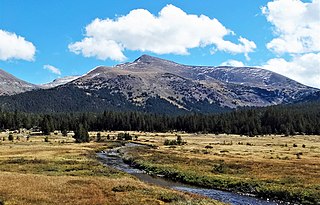
Mount Gibbs is located in the Sierra Nevada of the U.S. state of California, 2.6 miles (4 km) south of Mount Dana. The mountain was named in honor of Oliver Gibbs, a professor at Harvard University and friend of Josiah Whitney. The summit marks the boundary between Yosemite National Park and the Ansel Adams Wilderness, and Mount Gibbs is the sixth-highest mountain, of Yosemite.

Mount Williamson, at an elevation of 14,379 feet (4,383 m), is the second-highest mountain in both the Sierra Nevada range and the state of California, and the sixth-highest peak in the contiguous United States.

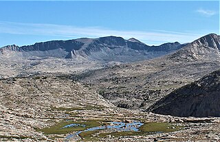
Mount Maclure is the nearest neighbor to Mount Lyell, the highest point in Yosemite National Park. Mount Maclure is the fifth-highest mountain of Yosemite. Mount Maclure is located at the southeast end of the Cathedral Range, about 0.6 miles (0.97 km) northwest of Lyell. The summit is on the boundary between Madera and Tuolumne counties, which is also the boundary between the park and the Ansel Adams Wilderness. It was named in honor of William Maclure, a pioneer in American geology who produced the first geological maps of the United States. Maclure Glacier, one of the last remaining glaciers in Yosemite, is situated on the mountain's northern flank.

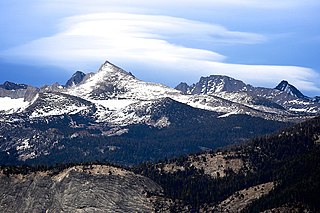
Mount Clark is a 11,527-foot (3,513 m) granite peak in the Clark Range, a sub-range of the Sierra Nevada. It is a popular destination for mountaineers.

Matthes Crest is an approximately mile-long fin of rock with two summits separated by a deep notch. It is a part of the Cathedral Range, which is a mountain range in the south-central portion of Yosemite National Park. The range is part of the Sierra Nevada.
Kuna Peak is a summit on the boundary between Mono and Tuolumne counties, in the United States, is the highest point on Kuna Crest. With an elevation of 13,008 feet (3,965 m), Kuna Peak is the 146th-highest summit in the state of California, and is the third-highest mountain in Yosemite National Park.

Blacktop Peak is a 12,724-foot-elevation mountain summit located along the crest of the Sierra Nevada mountain range, in Mono County of northern California, United States. It is situated in the Ansel Adams Wilderness, on land managed by Inyo National Forest. The summit lies one-half mile outside of Yosemite National Park's eastern boundary, and some of the lower western slope lies within the park. Blacktop Peak ranks as the 228th-highest summit in the state of California.

Johnson Peak is the highest mountain, in Tuolumne Meadows, Yosemite National Park.

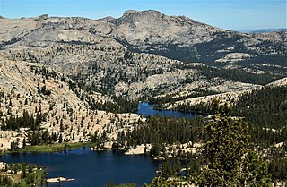
Hiking, rock climbing, and mountain climbing around Tuolumne Meadows in Yosemite National Park has many options.
Tuolumne Peak is a mountain, in Yosemite National Park, in the area of Tuolumne Meadows. It is a fractured granite, twin summited peak, and is close to geographic center of the park. Tuolumne Peak is located approximately 2.5 miles (4.0 km) northeast of Mount Hoffmann via a granite ridge-line. It is climbed less often than Hoffman, probably due to a more difficult approach.

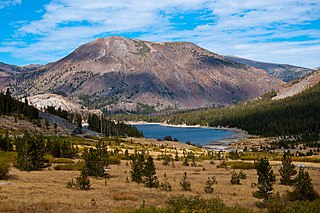
Mammoth Peak is a mountain in the area of Tuolumne Meadows, Yosemite National Park, California. The summit is a class 1-2 cross-country hike that features river crossings and boulder scrambling. The peak lies at the northern end of the Kuna Crest and is close to California State Route 120. From the road, its summit appears rounded and quite rocky. Though Mammoth Peak is not as popular as other nearby peaks, its relatively easily accessed summit affords tremendous views of Mount Gibbs, Mount Dana, and Mount Lewis.

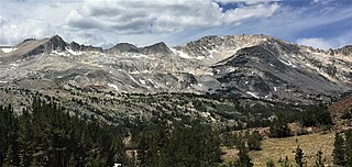
Kuna Crest is a mountain range near Tuolumne Meadows, in Yosemite National Park, California.
Tioga Peak is located in Mono County, California, approximately two miles outside of Yosemite National Park. It is situated in the Hoover Wilderness on land managed by Inyo National Forest.

Rodgers Peak is the most northwestern peak in the Ritter Range in Madera County, California. The peak lies on the boundary between Yosemite National Park and the Ansel Adams Wilderness further east. Rodgers Peak is the fourth-highest mountain in Yosemite National Park.
Mount Florence is a mountain, in the Tuolumne Meadows region of Yosemite National Park. Its easiest route is a class 2 scramble. Mount Florence is the tenth highest mountain in Yosemite. Deep in the Yosemite backcountry, Mount Florence is not often climbed, though on the trip, one passes through spectacular scenery, on all approaches.
False White Mountain is a mountain, in the northern part of Yosemite National Park. It is the 24th highest mountain, in Yosemite National Park. False White Mountain can be climbed, as a day hike, from Tioga Pass.

Virginia Peak is a mountain summit in the northern part of Yosemite National Park, north of Tuolumne Meadows. It is the 25th-highest mountain in Yosemite National Park.

Stanton Peak is a granitic mountain with a summit elevation of 11,695 feet (3,565 m) located in the Sierra Nevada mountain range, in Tuolumne County of northern California, United States. The remote summit is set within Yosemite National Park, and is situated 0.63 mile southwest of line parent Virginia Peak, 1.6 mile southeast of Whorl Mountain, and 2.6 miles south-southeast of Matterhorn Peak. Stanton Peak is bound on the west by Spiller Creek and on the east by Return Creek, so precipitation runoff from this mountain drains into these two tributaries of the Tuolumne River. Topographic relief is significant as the summit rises over 2,100 feet above Spiller Creek in one mile.

Gaylor Peak is an 11,004-foot-elevation (3,354 meter) mountain summit located on the crest of the Sierra Nevada mountain range in northern California, United States. The peak is situated on the common boundary shared by Yosemite National Park with Inyo National Forest, as well as the border shared by Mono County with Tuolumne County. It rises immediately above the park's Tioga Pass entrance station and Tioga Lake. Topographic relief is significant as the summit rises approximately 1,400 feet above the lake in one-half mile (0.80 km). The peak is a popular hiking destination on summer weekends due to easy access via the two-mile Gaylor Lakes Trail from State Route 120 which traverses the east base of the peak.
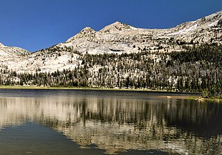
Rafferty Peak is an 11,110-foot-elevation mountain summit located in Yosemite National Park, in California, United States. It is situated on the common border shared by Mariposa and Tuolumne Counties. It is set south of Tuolumne Meadows in the Cathedral Range which is a sub-range of the Sierra Nevada mountain range. The mountain rises one mile (1.6 km) northwest of Tuolumne Pass, 1.4 mile south of Johnson Peak, and 2.5 miles east of Matthes Crest. Tuolumne Pass is the low point of the saddle between Rafferty Peak and Fletcher Peak. Topographic relief is significant as the summit rises 1,500 feet above Nelson Lake in one mile.


