
Tosontsengel is a sum of Khövsgöl aimag. The area is 2,050 km2, of which 1,800 km2 are pasture and 11 km2 are farmland. In 2000, Tosontsengel had a population of 4,161 people, including some Khotgoid. The sum center, officially named Tsengel, is located 64 km east-southeast of Mörön and 607 km from Ulaanbaatar.

Tsagaannuur is a sum of Khövsgöl aimag. The area is 5,410 km2. In 2000, Tsagaannuur had a population of 1,317 people, of which most identified themselves as Darkhad. There were 269 inhabitants who identified themselves as Tsaatan ethnicity. The sum center, officially named Gurvansaikhan, is located at the shore of Dood Tsagaan Lake.

Bürentogtokh is a sum (district) of Khövsgöl aimag. The area is about 3,760 km², of which 2,870 km² are pasture. In 2005, the sum had 4251 inhabitants, mainly Khalkha and Khotgoid. The center, officially named Bayan is situated on the banks of the Delgermörön river, 51 km west of Mörön and 722 kilometers from Ulaanbaatar.

Tsagaan-Üür is a sum of Khövsgöl aimag. The area is 8,730 km2, of which only 1,140 km2 are pasture. In 2000, Tsagaan-Üür had a population of 2,421 people, including Khalkha, Uriankhai, and Buriad. The sum center, officially named Bulgan, is located on the banks of the Üür River, 173 km north-east of Mörön and 844 km from Ulaanbaatar.

Alag-Erdene is a sum (district) of Khövsgöl aimag (province). The area is about 4,500 km², of which 1,460 km² are forest, and 2,760 km² are pasture. In 2005, the sum had 2992 inhabitants, including some Darkhad, Khotogoid, and Uriankhai. The center, officially named Mankhan is situated close to the road from Mörön to Khatgal, 62 km north of Mörön and 733 kilometers from Ulaanbaatar.

Arbulag is a sum of Khövsgöl aimag. The area is about 3,360 km², of which 3,120 km² are pasture. In 2000, the sum had 4478 inhabitants, mainly Khotgoid and Darkhad. The center, officially named Mandal is located 75 km northwest of Mörön and 742 kilometers from Ulaanbaatar.

Bayanzürkh is a sum (district) of Khövsgöl aimag (province) in Mongolia. The area is about 4,300 km2 (1,700 sq mi), of which 2,600 km2 (1,000 sq mi) are pasture. In 2000, the sum had 4202 inhabitants, mainly Darkhad. The center, officially named Altraga, is located at the confluence of the Altraga and Beltes rivers, near the Delgermörön river, 127 km northwest of Mörön and 798 kilometres (496 mi) from Ulaanbaatar.

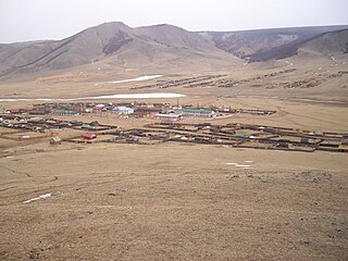
Rashaant is a sum of Khövsgöl aimag. The area is about 1,980 km², of which 50 km² are farmland. In 2000, the sum had 3280 inhabitants. The town of Rashaant, the aimag center, is located in a high valley, 154 km southeast of Mörön and 518 kilometers from Ulaanbaatar and had 978 inhabitants in 2009.

Tsagaan-Uul is a sum of Khövsgöl aimag. The area is about 5,870 km², of which 5,190 km² are pasture. In 2005, the sum had 5145 inhabitants, mainly Khalkha and Khotgoid. The center officially named Sharga, is located 138 km west of Mörön and 840 kilometers from Ulaanbaatar.

Chandmani-Ondor is a sum of Khövsgöl aimag. The area is about 4,490 km2. In 2000, the sum had 3036 inhabitants, including some Uriankhai. The center, officially named Khukhuu is located 190 km north-northeast of Mörön and 758 kilometers from Ulaanbaatar.

Erdenebulgan is a sum of Khövsgöl aimag. The area is about 4,960 km². In 2000, the sum had 2739 inhabitants. The center, officially named Eg-Üür, is situated on the banks of the Egiin gol.

Galt is a sum (district) of Khövsgöl aimag. The area is about 3,600 km2. In 2000, the district had 5328 inhabitants. The center, officially named Ider, is located 168 km south of the city of Mörön and 837 kilometers from the capital city, Ulaanbaatar.

Khankh is a sum of Khövsgöl aimag. The area is about 5,500 km2 (2,100 sq mi). In 2000, the sum had a population of 2,140 inhabitants. The center, officially named Turt, is situated on the shore of Lake Khövsgöl, 280 km (170 mi) north of Mörön, 1,020 km (630 mi) from Ulaanbaatar, and 22 km (14 mi) from the Khankh/Mondy border crossing to Russia.

Ikh-Uul is a sum of Khövsgöl aimag. The area is about 2,020 km², of which 1,350 km² are pasture and about 11 km² are farmland. In 2000, the sum had 3959 inhabitants, mainly Khalkha and Khotgoid. The center, officially named Selenge, is situated close to the Selenge river, 112 km east of Mörön and 589 kilometers from Ulaanbaatar.

Jargalant is a sum (district) of Khövsgöl Province in Mongolia. The sum's area is about 2,550 km2 (980 sq mi), of which 1,470 km2 (570 sq mi) are pasture. In 2000, the sum had 5,068 inhabitants, mainly Khalkha. The center, officially named Orgil, is situated close to the Ider river, 182 kilometres (113 mi) south-southeast of Mörön and 886 kilometres (551 mi) from Ulaanbaatar.

Tarialan is a sum of Khövsgöl aimag. The area is 3,431 square kilometres (1,325 sq mi), of which 1,582 square kilometres (611 sq mi) are pasture and 167 square kilometres (64 sq mi) are arable land . In 2007, Tarialan had a population of 5,855 people. The sum center, officially named Badrakh, in 2007 had 2,981 inhabitants and was the 2nd most populous settlement in the aimag after its capital. The sum center is located 160 kilometres (99 mi) east of Mörön and 521 kilometres (324 mi) from Ulaanbaatar.

Tömörbulag is a sum of Khövsgöl aimag. The area is 2,510 km2, of which about 1,950 km2 are pasture. In 2000, Tömörbulag had a population of 4,174 people, including some Khotgoid. The sum center, officially named Jargalant, is located near the Bügsiin River, 75 south of Mörön and 714 km from Ulaanbaatar.

Tsetserleg is a sum of Khövsgöl aimag, Mongolia. The area is 7,480 km2, of which 6,040 km2 are pasture and 1,340 km2 are forest. 15 km2 are farmland. In 2000, Tsetserleg had a population of 5,876 people, mainly Khotgoid. The sum center, officially named Khalban, is located 209 km west of Mörön and 880 km from Ulaanbaatar.
Tünel is a sum of Khövsgöl aimag. The area is 3,580 km2, of which about one third is forest. In 2000, Tünel had a population of 4,556 people, including some Khotgoid. The sum center, officially named Bulag, is located 46 km north-east of Mörön and 667 km from Ulaanbaatar.

Ulaan-Uul is a sum of Khövsgöl aimag. The area is close to 10,000 km2. In 2000, Ulaan-Uul had a population of 3,726 people, mainly Darkhad. The sum center, officially named Tögöl, is located 171 km north-north-west of Mörön and 942 km from Ulaanbaatar.
