Khövsgöl Province

Last updated • 3 min readFrom Wikipedia, The Free Encyclopedia
Khövsgöl Province
Хөвсгөл аймаг
ᠬᠥᠪᠰᠦᠭᠦᠯᠠᠶᠢᠮᠠᠭ
Burentogtokh.jpg
Scenery in the Khövsgöl Province
Mn flag khovsgol aimag 2014.svg
Mn coa khovsgol aimag 2014.svg
Khovsgol in Mongolia.svg
Coordinates: 49°38′N100°10′E / 49.633°N 100.167°E / 49.633; 100.167
CountryMongolia
Established1931 (1931)
Capital Mörön
Area
  Total100,628.82 km2 (38,853.00 sq mi)
Population
 (2017)
  Total132,146
  Density1.3/km2 (3.4/sq mi)
GDP
[1]
  Total MNT 952 billion
US$ 0.3 billion (2022)
  Per capitaMNT 6,905,270
US$ 2,211 (2022)
Time zone UTC+8
Area code +976 138
ISO 3166 code MN-041
Vehicle registration ХӨ_
Website khovsgol.gov.mn

Khövsgöl (Mongolian : Хөвсгөл) is the northernmost of the 21 aimags (provinces) of Mongolia. The name is derived from Lake Khövsgöl.

Contents

Geography and history

The round-topped Tarvagatai, Bulnain and Erchim sub-ranges of the Khangai massif dominate the south and southwest of the largely mountainous province, and north and west of Lake Khövsgöl, lie the alpine Khoridol Saridag, Ulaan Taiga, and Mönkh Saridag mountains. The center and eastern parts of the province are less mountainous, but still hilly.

The region is well known in Mongolia for its natural environment,[ citation needed ] and Lake Khövsgöl is one of the country's major tourist attractions. The largest forests of Mongolia are located around and to the north of the lake, extending the South Siberian taiga.

The aimag was founded in 1931. Khatgal was the administrative center until 1933; since then it has been Mörön.

Population

The region is home to many ethnic minority groups: Darkhad, Khotgoid, Uriankhai, Buriad, and Tsaatan. Both the Darkhad and Tsaatan are famous for their practice of shamanism.

Ethnic minority groups in Khövsgöl (self-identification), 2000 census [2]
GroupPopulationPercentage
Darkhad 16,26813.8%
Khotgoid 62295.3%
Uriankhai 30362.6%
Buriad 9960.84%
Tsaatan 2690.23%
Total population117914100%
Khövsgöl aimag population [3] [4] [5] [6] [7]
1956
census
1960
est.
1963
census
1969
census
1975
est.
1979
census
1981
est.
1989
census
1992
est.
1996
est.
1998
est.
2000
census
2003
est.
2005
est.
2007
est.
58,20064,00063,70074,80082,30088,20091,100101,800119,133113,312117,123117,914124,126123,416123,275

Famous Khövsgölians

Famous people from Khövsgöl include:

Henning Haslund-Christensen, a Danish traveller and explorer, spent one or two years in a place that today is in Erdenebulgan sum in the early 1920s. Some locals believe that Alan Gua, an ancestor of Genghis Khan, hails from what is now Chandmani-Öndör.

Livestock

In 2007, the aimag was home to about 3.43 million heads of livestock, among them about 1,510,000 goats, 1,442,000 sheep, 322,000 cattle and yaks, 150,000 horses, 2,350 camels, and 652 reindeer. [7]

Transportation

The Mörön Airport (ZMMN/MXV) has one paved runway. It offers regular flights from and to Ulaanbaatar, and also serves as intermediate stop into the western Aimags.

The Khatgal Airport (HTM) only runs scheduled flights from and to Ulaanbaatar in summer, offering a more direct approach to Lake Khövsgöl for the tourists.

The road distance from Mörön to Ulaanbaatar is 690 km. A new paved road finished in fall 2012 now connects Mörön to Khatgal on Lake Khövsgöl.

Administrative subdivisions

Sums of Khovsgol Mongolia Khovsgol sum map.png
Sums of Khövsgöl
Lake Khovsgol Hovsgol.jpg
Lake Khövsgöl
The Sums of Khövsgöl Aimag
Sum Mongolian Population
1987
(approx.) [8]
Population
1994
[9]
Population
2000 [10]
Population 2005 [11] Population
2009 [12]
Sum centre
population
(2009) [12]
Area
(km²) [7]
Density
(/km²)
Alag-Erdene
Khatgal
Алаг-Эрдэнэ
Хатгал
2,300
7,000 [13]
2,809
3,756
2,825
2,498
2,992
2,831
2,980
2,952
744
2,952
3,591.5
911,4
0.83
3.24
Arbulag Арбулаг3,1004,2724,4874,1643,9897283,529.211.13
Bayanzürkh Баянзүрх3,3004,1804,2023,8633,9647424,299.140.92
Bürentogtokh Бүрэнтогтох3,8005,0434,6784,2514,2457353,768.601.12
Chandmani-Öndör Чандмань-Өндөр2,1002,8913,0632,9443,0061,0184,487.540.67
Erdenebulgan Эрдэнэбулган2,3003,0862,7392,8492,7631,0604,694.380.59
Galt Галт4,4005,5735,3284,8765,1327773,596.831.43
Ikh-Uul Их-Уул3,2003,7673,9594,1264,1701,3872,023.822.06
Jargalant Жаргалант3,7004,8665,0865,1095,1831,3152,549.282.03
Khankh Ханхn.a.2,2272,1402,3462,4601,4225,498.710.45
Mörön Мөрөнn.a.27,23028,14735,87236,08236,072102.90350.55
Rashaant Рашаант2,5003,1953,2803,5593,5019871,982.521.77
Renchinlkhümbe Рэнчинлхүмбэ3,900 [14] 4,0404,2844,6144,7408258,448.340.56
Shine-Ider Шинэ-Идэр3,9004,6164,3484,0683,8241,7182,053.561.86
Tarialan Тариалан4,8006,1226,0705,9366,0853,2723,430.671.77
Tömörbulag Төмөрбулаг3,1004,0844,1714,3534,1746132,521.721.66
Tosontsengel Тосонцэнгэл2,8003,6834,1613,6154,1441,1662,042.232,03
Tsagaannuur Цагааннуур9001,2481,3171,4051,5477085,408.300.29
Tsagaan-Uul Цагаан-Уул4,3005,5475,6965,1455,3329405,866.30.91
Tsagaan-Üür Цагаан-Үүр2,0002,5902,4212,4422,4599468,735.330.28
Tsetserleg Цэцэрлэг4,4005,5915,8764,6934,7668077,451.620.64
Tünel Түнэл2,9003,5793,5563,4653,5281,1053,577.330.99
Ulaan-Uul Улаан-Уул2,7003,3963,7263,8984,1181,38610,057.520.41

Notes and references

  1. "GROSS DOMESTIC PRODUCT, by region, aimags and the Capital". www.1212.mn. Mongolian Statistical Information Service. Retrieved 2023-12-06.
  2. M. Nyamaa, Khövsgöl aimgiin lavlakh toli, Ulaanbaatar 2001, p. 7, 35, 68, 148, 166, 190
  3. "Mongolia Provinces". www.statoids.com. Archived from the original on March 28, 2023. Retrieved 2024-01-30.
  4. National Statistical Office Archived 2007-06-07 at the Wayback Machine
  5. National Economy of the Mongolian People's Republic (1921 - 1981), Ulaanbaatar 1981
  6. , GeoHive: Global Statistics
  7. 1 2 3 Khövsgöl Aimag Statistical Yearbook 2007 [ permanent dead link ]
  8. Khövsgöl Aimgiin Atlas, Ulaanbaatar 1988,p.6
  9. https://wayback.archive-it.org/all/20070705123128/http://www.reliefweb.int/library/documents/oxfamannex1-4.pdf [ bare URL PDF ]
  10. M. Nyamaa, Khövsgöl aimgiin lavlakh toli, Ulaanbaatar 2001,passim
  11. Rural Poverty Reduction Programme: official site Archived 2007-09-28 at the Wayback Machine
  12. 1 2 Khövsgöl Aimak Statistical Yearbook 2009 [ permanent dead link ]
  13. population in 1990, acc. to M. Nyamaa, Khövsgöl aimgiin lavlakh toli
  14. incl. parts of Khankh

Related Research Articles

Tosontsengel is a sum of Khövsgöl aimag. The area is 2,050 km2, of which 1,800 km2 are pasture and 11 km2 are farmland. In 2000, Tosontsengel had a population of 4,161 people, including some Khotgoid. The sum center, officially named Tsengel, is located 64 km east-southeast of Mörön and 607 km from Ulaanbaatar.

<span class="mw-page-title-main">Mörön</span> Provincial capital of Khövsgöl Province, Mongolia

Mörön, also spelled Murun, is the administrative center of Khövsgöl Aimag (province) in northern Mongolia. Before 1933, Khatgal had been the aimag capital.

Tsagaannuur is a sum of Khövsgöl aimag. The area is 5,410 km2. In 2000, Tsagaannuur had a population of 1,317 people, of which most identified themselves as Darkhad. There were 269 inhabitants who identified themselves as Tsaatan ethnicity. The sum center, officially named Gurvansaikhan, is located at the shore of Dood Tsagaan nuur, 279 km north-north-east of Mörön and 1048 km from Ulaanbaatar.

<span class="mw-page-title-main">Renchinlkhümbe</span> District in Khövsgöl Province, Mongolia

Renchinlkhümbe is a sum of Khövsgöl Province in Mongolia. The area is about 8,850 square kilometres (3,420 sq mi), of which 2,910 square kilometres (1,120 sq mi) are pasture and 35% are forest. In 2000, the sum had 4284 inhabitants, mainly Darkhad. The sum center, officially named Zöölön, is 265 kilometres (165 mi) north of Mörön and 998 kilometres (620 mi) from Ulaanbaatar.

<span class="mw-page-title-main">Tsagaan-Üür, Khövsgöl</span> District in Khövsgöl Province, Mongolia

Tsagaan-Üür is a sum of Khövsgöl aimag. The area is 8,730 km2, of which only 1,140 km2 are pasture. In 2000, Tsagaan-Üür had a population of 2,421 people, including Khalkha, Uriankhai, and Buriad. The sum center, officially named Bulgan, is located on the banks of the Üür River, 173 km north-east of Mörön and 844 km from Ulaanbaatar.

<span class="mw-page-title-main">Alag-Erdene, Khövsgöl</span> District in Khövsgöl Province, Mongolia

Alag-Erdene is a sum (district) of Khövsgöl aimag (province). The area is about 4,500 km², of which 1,460 km² are forest, and 2,760 km² are pasture. In 2005, the sum had 2992 inhabitants, including some Darkhad, Khotogoid, and Uriankhai. The center, officially named Mankhan is situated close to the road from Mörön to Khatgal, 62 km north of Mörön and 733 kilometers from Ulaanbaatar.

<span class="mw-page-title-main">Arbulag, Khövsgöl</span> District in Khövsgöl Province, Mongolia

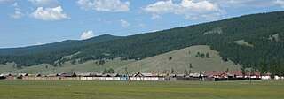
Arbulag is a sum of Khövsgöl aimag. The area is about 3,360 km², of which 3,120 km² are pasture. In 2000, the sum had 4478 inhabitants, mainly Khotgoid and Darkhad. The center, officially named Mandal is located 75 km northwest of Mörön and 742 kilometers from Ulaanbaatar.

<span class="mw-page-title-main">Bayanzürkh, Khövsgöl</span> District in Khövsgöl Province, Mongolia

Bayanzürkh is a sum (district) of Khövsgöl aimag (province) in Mongolia. The area is about 4,300 km2 (1,700 sq mi), of which 2,600 km2 (1,000 sq mi) are pasture. In 2000, the sum had 4202 inhabitants, mainly Darkhad. The center, officially named Altraga, is located at the confluence of the Altraga and Beltes rivers, near the Delgermörön river, 127 km northwest of Mörön and 798 kilometres (496 mi) from Ulaanbaatar.

<span class="mw-page-title-main">Rashaant, Khövsgöl</span> District in Khövsgöl Province, Mongolia

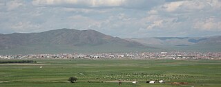
Rashaant is a sum of Khövsgöl aimag. The area is about 1,980 km², of which 50 km² are farmland. In 2000, the sum had 3280 inhabitants. The town of Rashaant, the aimag center, is located in a high valley, 154 km southeast of Mörön and 518 kilometers from Ulaanbaatar and had 978 inhabitants in 2009.

<span class="mw-page-title-main">Chandmani-Öndör, Khövsgöl</span> District in Khövsgöl Province, Mongolia

Chandmani-Ondor is a sum of Khövsgöl aimag. The area is about 4,490 km2. In 2000, the sum had 3036 inhabitants, including some Uriankhai. The center, officially named Khukhuu is located 190 km north-northeast of Mörön and 758 kilometers from Ulaanbaatar.

<span class="mw-page-title-main">Galt, Khövsgöl</span> District in Khövsgöl Province, Mongolia

Galt is a sum (district) of Khövsgöl aimag. The area is about 3,600 km2. In 2000, the district had 5328 inhabitants. The center, officially named Ider, is located 168 km south of the city of Mörön and 837 kilometers from the capital city, Ulaanbaatar.

<span class="mw-page-title-main">Khankh, Khövsgöl</span> District in Khövsgöl Province, Mongolia

Khankh is a sum of Khövsgöl aimag. The area is about 5,500 km2 (2,100 sq mi). In 2000, the sum had a population of 2,140 inhabitants. The center, officially named Turt, is situated on the shore of Lake Khövsgöl, 280 km (170 mi) north of Mörön, 1,020 km (630 mi) from Ulaanbaatar, and 22 km (14 mi) from the Khankh/Mondy border crossing to Russia.

Shine-Ider is a sum of Khövsgöl aimag. The area is about 2,050 km2, of which 1,700 km2 are pasture. In 2000, the sum had 4348 inhabitants, mainly Khalkha. The sum center, officially named Erdenet, is located 123 km south-southeast of Mörön and 839 kilometers from Ulaanbaatar.

Tarialan is a sum of Khövsgöl aimag. The area is 3,431 square kilometres (1,325 sq mi), of which 1,582 square kilometres (611 sq mi) are pasture and 167 square kilometres (64 sq mi) are arable land . In 2007, Tarialan had a population of 5,855 people. The sum center, officially named Badrakh, in 2007 had 2,981 inhabitants and was the 2nd most populous settlement in the aimag after its capital. The sum center is located 160 kilometres (99 mi) east of Mörön and 521 kilometres (324 mi) from Ulaanbaatar.

Tsetserleg is a sum of Khövsgöl aimag, Mongolia. The area is 7,480 km2, of which 6,040 km2 are pasture and 1,340 km2 are forest. 15 km2 are farmland. In 2000, Tsetserleg had a population of 5,876 people, mainly Khotgoid. The sum center, officially named Khalban, is located 209 km west of Mörön and 880 km from Ulaanbaatar.

<span class="mw-page-title-main">Tünel, Khövsgöl</span> District in Khövsgöl Province, Mongolia

Tünel is a sum of Khövsgöl aimag. The area is 3,580 km2, of which about one third is forest. In 2000, Tünel had a population of 4,556 people, including some Khotgoid. The sum center, officially named Bulag, is located 46 km north-east of Mörön and 667 km from Ulaanbaatar.

<span class="mw-page-title-main">Ulaan-Uul, Khövsgöl</span> District in Khövsgöl Province, Mongolia

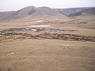
Ulaan-Uul is a sum of Khövsgöl aimag. The area is close to 10,000 km2. In 2000, Ulaan-Uul had a population of 3,726 people, mainly Darkhad. The sum center, officially named Tögöl, is located 171 km north-north-west of Mörön and 942 km from Ulaanbaatar.

The Delger mörön is a river in the Khövsgöl aimag in northern Mongolia. It rises in the Ulaan Taiga range close to the Russian border. It is 445 kilometres (277 mi) long, and has a drainage basin of 26,600 square kilometres (10,300 sq mi).

The Red Taiga is a mountain range in north-western Khövsgöl, Mongolia, between the Darkhad Valley and Mongolia's border with Tuva, Russia. The range covers parts of the Ulaan-Uul, Tsagaannuur and Bayanzürkh sums. Notable peaks include Mt. Lam Taiga (2619m) and Mt. Belchir (3351m). The Shishged River and the Delger mörön have their sources in this area. A part of the area along the border with Tuva has been put under natural protection.

<span class="mw-page-title-main">Khoridol Saridag mountains</span>

The Khoridol Saridag mountains are a 150 km-long mountain range in Khövsgöl aimag, Mongolia, between Khövsgöl nuur and the Darkhad valley. The range covers parts of the Renchinlkhümbe, Ulaan-Uul and Alag-Erdene sums. The highest peak is Delgerkhaan Uul (3093m), two other notable peaks are Ikh Uul (2961m) and Uran Dösh Uul (2702m) on the shores of Khövsgöl nuur.