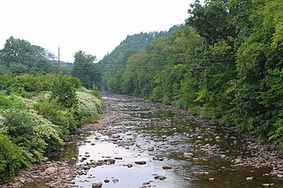
Muncy Creek is a tributary of the West Branch Susquehanna River in Sullivan County and Lycoming County, in Pennsylvania, in the United States. It is approximately 34.5 miles (55.5 km) long. The watershed of the creek has an area of 216 square miles (560 km2). The creek's discharge averages 49 cubic feet per second (1.4 m3/s) at Sonestown, but can be up to a thousand times higher at Muncy. The headwaters of the creek are on the Allegheny Plateau. Rock formations in the watershed include the Chemung Formation and the Catskill Formation.

Larrys Creek is a 22.9-mile-long (36.9 km) tributary of the West Branch Susquehanna River in Lycoming County in the U.S. state of Pennsylvania. A part of the Chesapeake Bay drainage basin, its watershed drains 89.1 square miles (231 km2) in six townships and a borough. The creek flows south from the dissected Allegheny Plateau to the Ridge-and-valley Appalachians through sandstone, limestone, and shale from the Devonian, Mississippian, and Pennsylvanian periods.
Huntington Creek is a tributary of Fishing Creek in Luzerne and Columbia counties, Pennsylvania, in the United States. It is approximately 29.5 miles (47.5 km) long.

Little Fishing Creek is a tributary of Fishing Creek in Sullivan County, Lycoming County, and Columbia County, in Pennsylvania, in the United States. It is approximately 23.5 miles (37.8 km) long and flows through eight townships. The watershed of the creek has an area of 68.1 square miles (176 km2). The creek has six named tributaries, of which the largest are Spruce Run and West Branch Run.

Lick Run is a tributary of Little Fishing Creek in Lycoming County and Columbia County, in Pennsylvania, in the United States. It is approximately 5.2 miles (8.4 km) long and flows through Jordan Township in Lycoming County and Pine Township, in Columbia County. The watershed of the stream has an area of 4.40 square miles (11.4 km2). The entire drainage basin is considered to be a Coldwater Fishery and a portion of the stream is considered to be Class A Wild Trout Waters. At least one bridge crosses the stream.

Wolfhouse Run is a tributary of Little Fishing Creek in Columbia County, Pennsylvania, in the United States. It is approximately 2.9 miles (4.7 km) long and flows through Pine Township. The watershed of the stream has an area of 2.03 square miles (5.3 km2). The steam is considered to be an Exceptional Value stream and a Coldwater Fishery. However, it is considered to be impaired as well. At least two bridges and one sawmill have been built over or on the stream.

Devil Hole Run is a tributary of Little Fishing Creek in Columbia County, Pennsylvania, in the United States. It is approximately 2.7 miles (4.3 km) long and flows through Pine Township. The stream is mostly surrounded by forested land and it is part of a Locally Significant Area listed on the Columbia County Natural Areas Inventory. It has a single named tributary. Plantlife common in the vicinity of the stream include hemlock trees. Trout inhabit the stream itself.

Kline Hollow Run is a tributary of Devil Hole Run in Lycoming County and Columbia County, in Pennsylvania, in the United States. It is approximately 3.6 miles (5.8 km) long and flows through Jordan Township in Lycoming County and Pine Township in Columbia County. The stream is mostly surrounded by forested land and it is part of a Locally Significant Area listed on the Columbia County Natural Areas Inventory. Plantlife common in the vicinity of the stream include hemlock trees and trout inhabit the stream itself. The stream is considered to be an Exceptional Value stream.

Little Brier Run is a tributary of Little Fishing Creek in Lycoming County and Columbia County, in Pennsylvania, in the United States. It is approximately 2.9 miles (4.7 km) and flows through Jordan Township in Lycoming County and Pine Township in Columbia County. The watershed of the stream has an area of 2.62 square miles (6.8 km2). The stream itself is inhabited by trout and is considered to be an Exceptional Value stream and a Migratory Fishery. It has one unnamed tributary. Various wetlands are present in the vicinity of the stream and its unnamed tributary.

Mitchler Run is a tributary of Huntington Creek in Luzerne County, Pennsylvania, in the United States. It is approximately 1.9 miles (3.1 km) long and flows through Ross Township. The watershed of the stream has an area of 1.52 square miles (3.9 km2) and the stream has no named tributaries. The stream is considered by the Pennsylvania Fish and Boat Commission to be Class A Wild Trout Waters for brook trout.
Shingle Run is a tributary of Huntington Creek in Luzerne County, Pennsylvania, in the United States. It is approximately 1.8 miles (2.9 km) long and flows through Ross Township. The watershed of the stream has an area of 1.83 square miles (4.7 km2) and it has no tributaries. The stream is considered to be Class A Wild Trout Waters for its entire length. Additionally, it is listed in the Luzerne County Natural Areas Inventory. Various species of butterfly inhabit the stream's vicinity. Trees in the area include hemlocks and yellow birches. The stream is small, but nevertheless is perennial.
Wasp Branch is a tributary of Pine Creek in Luzerne County, Pennsylvania, in the United States. It is approximately 1.7 miles (2.7 km) long and flows through Fairmount Township. The watershed of the stream has an area of 0.90 square miles (2.3 km2). The stream is considered to be Class A Wild Trout Waters, a Coldwater Fishery, and a Migratory Fishery. Glacial till and bedrock consisting of stone and shale can be found in the stream's vicinity.

Elk Run is tributary of West Branch Fishing Creek in Sullivan County and Columbia County, in Pennsylvania, in the United States. It is approximately 4.8 miles (7.7 km) long and flows through Davidson Township in Sullivan County and Sugarloaf Township in Columbia County. The watershed of the stream has an area of 7.49 square miles (19.4 km2). The stream has three named tributaries: Gallows Run, Hog Run, and Long Run. Elk Run is considered to be an Exceptional Value stream and a Migratory Fishery. The forests surrounding it are deemed by the Sullivan County Natural Areas Inventory to be a "locally significant" area. The stream is named for an elk that was killed in it in the 1840s.
Shingle Mill Run is a tributary of West Branch Fishing Creek in Sullivan County, Pennsylvania, in the United States. It is approximately 2.4 miles (3.9 km) long and flows through Davidson Township. The watershed of the stream has an area of 2.60 square miles (6.7 km2). The stream has one named tributary, Bearwallow Run. Shingle Mill Run is designated as an Exceptional Value stream and has a population of native trout. The stream has high water quality and is slightly acidic. Boulder Colluvium and bedrock consisting of sandstone and shale can be found near the stream.
Deep Hollow is a tributary of West Branch Fishing Creek in Luzerne County, Pennsylvania, in the United States. It is approximately 0.8 miles (1.3 km) long and flows through Davidson Township. The watershed of the stream has an area of 0.53 square miles (1.4 km2). Wild trout naturally reproduce in the stream. The surficial geology in the area mainly features bedrock consisting of sandstone and shale, as well as a small amount of Boulder Colluvium and alluvium.
Spencer Run is a tributary of West Creek in Columbia County, Pennsylvania, in the United States. It is approximately 2.1 miles (3.4 km) long and flows through Jackson Township and Benton Township. The watershed of the stream has an area of 2.07 square miles (5.4 km2). Wild trout naturally reproduce in the stream. The surficial geology in the area mainly features Illinoian Till, Illinoian Leg, alluvium, colluvium, and bedrock.
York Hollow is a tributary of West Creek in Columbia County, Pennsylvania, in the United States. It is approximately 2.5 miles (4.0 km) long and flows through Jackson Township and Sugarloaf Township. The watershed of the stream has an area of 1.47 square miles (3.8 km2). Wild trout naturally reproduce in the stream. The surficial geology in the area mainly consists of Illinoian Till, Illinoian Lag, alluvium, colluvium, and bedrock.
Brish Run is a tributary of Pine Creek in Luzerne County, Pennsylvania, in the United States. It is approximately 1.5 miles (2.4 km) long and flows through Fairmount Township. The watershed of the stream has an area of 0.66 square miles (1.7 km2). The stream has one unnamed tributary. The surficial geology in the vicinity of Brish Run mostly consists of Wisconsinan Till, but there is alluvium near its mouth and also bedrock in the area. The stream is being considered for wild trout designation.
Black Run is a tributary of the West Branch Susquehanna River in Lycoming County and Union County, in Pennsylvania, in the United States. It is approximately 3.6 miles (5.8 km) long and flows through Brady Township in Lycoming County and Gregg Township in Union County. The watershed of the stream has an area of 5.87 square miles (15.2 km2). The stream is not designated as an impaired waterbody. It is a relatively small stream with its mouth located near Montgomery. The stream's watershed is designated as a Warmwater Fishery and a Migratory Fishery.


