
Sangli (pronunciation , is a city and the district headquarters of Sangli District in the state of Maharashtra, in western India. It is known as the Turmeric City of Maharashtra due to its production and trade of the spice. Sangli is situated on the banks of river Krishna and houses many sugar factories. Sangli is a major city in Western India 390 km from Mumbai,240 km from Pune and 700 km from Bangalore. Sangli is known for its turmeric trade, grapes and the largest number of sugar factories in India. The only district has more than 30 sugar factories. Sangli Miraj Kupwad,along with its Urban Agglomeration together known as Sangli Miraj Kupwad Metropolitan Region.

Ugar Khurd is a town municipal council in the district of Belagavi, in the state of Karnataka, in India. The town is famous for Ugar Sugar Works. It lies on the banks of mighty Krishna River. As per 2011 census the population of town is about 23,762, of whom almost 2,000 work in Ugar Sugar Works. Ugar is just 33 km from Sangli Miraj twin cities and is emerging as a satellite town connected with Miraj Sangli and Belagavi
Satara district is a district of Maharashtra state in western India with an area of 10,480 km² and a population of 3,003,741 of which 14.17% were urban. Satara is the capital of the district and other major towns include Wai, Karad, Koregaon, Dahiwadi, Koynanagar, Rahimatpur, Phaltan, Mahabaleshwar, Vaduj and Panchgani. This district comes under Pune Administrative Division along with Pune, Sangli, Solapur and Kolhapur. The district of Pune bounds it to the north, Raigad bounds it to the north-west, Solapur the east, Sangli to the south, and Ratnagiri to the west.
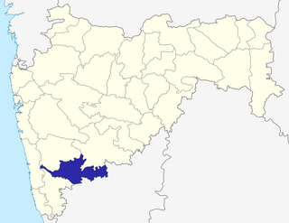
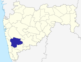
Sangli District is a district of Maharashtra State in west-central India. Sangli City is the district headquarters. The district is 25.11% urban. Sangli and Miraj are the largest cities. The industrial town of Kirloskarwadi is also located in the Sangli District. Industrialist Laxmanrao Kirloskar started his first factory here. It is known as the sugar bowl of India due to its high sugarcane productivity. Sangli District is one of the most fertile and highly developed districts in Maharashtra. The District is very popular as a political power house in the state. It has provided many politicians and bureaucrats and is often referred to as the Heaven of Farmers.
Sangli-Miraj & Kupwad is a metropolitan and a municipal corporation in Sangli district in the Indian state of Maharashtra.
Tasgaonpronunciation (help·info) is a city and a municipal council in Sangli district in the Indian state of Maharashtra. Tasgaon was given as Jahagir to Parshuram Bhau Tasgaonkar by Narayan Ballal Peshava in 1774.
Urun Islampur is a city and a municipal council in Sangli district in the Indian state of Maharashtra.
Atpadi is an administrative town of the Atpadi Taluka of Sangli District in the Indian state of Maharashtra. Atpadi is located north-east of Sangli District and shares borders with the adjacent Solapur and Satara Districts. The town has a taluka administrative office, a courthouse, a police station, a government-run primary hospital, various schools and colleges and a theater. Atpadi's economy is based on the cultivation and sale of agricultural products, with pomegranates and cotton constituting the core of the industry. The town is also home to the Manganga Sahakari Sugar factory, a Pomegranate auction center and various small scale industries in fields such as manufacturing, processing, servicing and repairs.
Athani is a city next to Gokak in the Belgaum district of Karnataka, India. It is 140 kilometers from the city of Belagavi, 70 kilometers from Vijayapura, 55 kilometers from Miraj, 100 kilometers from Kolhapur, 200 kilometers from Hubballi, and 624 kilometers from Bengaluru. The main profession here is agriculture, particularly sugarcane, jawar, and grapes. The river Krishna flows 110 km around the southern part of Athani Taluk. the city 18 km from river Krishna It is the largest sugar production Taluk in Karnataka. It is famous for leather chappals. Athani is the oldest municipal town of Karnataka; it was established in 1853 according to the municipal act of 1850,The municipal council completed 160 years.
Shirgav at Walwa in Sangli district, in Maharashtra, India, is a tiny village situated on the banks of river Krishna.
Kabbur is a town in the southern state of Karnataka, India. It is located in the Chikodi taluk of Belgaum district in Karnataka.
Kurli is a village in the southern state of Karnataka, India. It is located in the Chikodi taluk of Belgaum district in Karnataka.
Madabhavi is a large village located in Athani taaluk of Belagavi district, Karnataka state of India. The village is famous for production leather chappals which have main market in Kolhapur. The village name came from Madya means central and Bhavi means open well. Open well is near panchayat of village.This village Has two Oldest Ancients Temples one Kalbhairava and another one is Madhukeshwar temple.

Mangasuli is a village located in Northern Karnataka, India. It is located in the Athani taluk of Belgaum district in Karnataka.
Walwa is a town and a tehsil in Sangli district in the Indian state of Maharashtra. It is also known as Valva-Islampur Taluka. There are ninety-five panchayat villages in Walwa Taluka.
Atigre is a village in Kolhapur district in the Indian state of Maharashtra, in western India. It is situated on Kolhapur-Sangli Highway about 410 kilometres (250 mi) from Mumbai, 17km from Kolhapur, 8km from Hatkanangle, 35km from Sangli, and 12km from Ichalkaranji.
Bamani(Vita) is a village in the Khanapur taluka of Sangli district in Maharashtra, India. Bamani is 14 km away from prominent city vita and 5 km from vita-tasgaon road. The village is Surrounded by villages Pare, Mangrul, Ghatimbi, Chinchni, Padli, Visapur, Limb, Hatnur. Bamani comes under Khanapur-Atpadi state constituency and sangli parliamentary constituency. Vita-Kavthe Mhankal state road goes through Bamani. Bamani is last village in khanapur Taluka. Bamani is agriculture based village. Bamani also have lots of animal husbandry farms like Buffalo farm, Cow Farm, Goat Farm, Country Poultry farm.
Vashi is a Village in the state of Maharashtra, India. Administratively, Vashi is under Walwa Taluka of Sangli District in Maharashtra. Vashi is the only village in its gram panchayat. The village of Vashi is 21 km by road south of the city of Uran Islampur and 33 km by road west of the city of Ashta.
Erandoli is a village in Miraj Taluka in Sangli District of Maharashtra State, India. It belongs to Desh or Paschim Maharashtra region. It is in Pune Division. It is located 9 km East from the district headquarters Sangli and 361 km from the state capital at Mumbai

Vaduj is a town in the Satara district of Maharashtra, India. It is the headquarters of Khatav Taluka of the Satara district. The town located on the banks of the Yerala river, is around 58 kilometres (36 mi) away from its district center Satara, and 165 kilometres (103 mi) away from Pune. Existing in the Pune division of Maharashtra, it's the biggest town in Khatav Taluka, with a population of around 17,636 people. According to the 2011 population census, it has a literacy rate of more than 86%, which is above the national average. Recently, its status was changed to Nagar Panchayat by a new ruling of the state government.

