
Kangchenjunga, also spelled Kanchenjunga, Kanchanjanghā and Khangchendzonga, is the third-highest mountain in the world. Its summit lies at 8,586 m (28,169 ft) in a section of the Himalayas, the Kangchenjunga Himal, which is bounded in the west by the Tamur River, in the north by the Lhonak River and Jongsang La, and in the east by the Teesta River. It lies in the border region between Koshi Province of Nepal and Sikkim state of India, with the two peaks West and Kangbachen in Nepal's Taplejung District and the other three peaks Main, Central and South directly on the border.

Makalu is the fifth-highest mountain on Earth, with a summit at an elevation of 8,485 metres (27,838 ft) AMSL. It is located in the Mahalangur Himalayas 19 km (12 mi) southeast of Mount Everest, on the China–Nepal border. One of the eight-thousanders, Makalu is an isolated peak shaped like a four-sided pyramid.
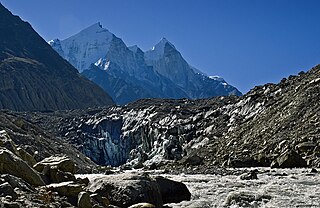
Gangotriglacier is located in Uttarkashi District, Uttarakhand, India in a region bordering Tibet. This glacier, one of the primary sources of the Ganges, has a volume of over 27 cubic kilometers. The glacier is about 30 kilometres long and 2 to 4 km wide. Around the glacier are the peaks of the Gangotri Group, including several peaks notable for extremely challenging climbing routes, such as Shivling, Thalay Sagar, Meru, and Bhagirathi III. It flows roughly northwest, originating in a cirque below Chaukhamba, the highest peak of the group.

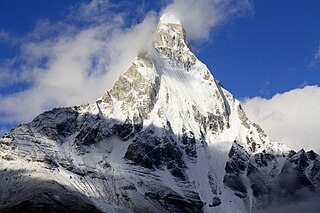
Ama Dablam is a mountain in the eastern Himalayan range of Koshi Province, Nepal. The main peak is 6,812 metres (22,349 ft), the lower western peak is 6,170 metres (20,243 ft). Ama Dablam means "mother's necklace"; the long ridges on each side like the arms of a mother (ama) protecting her child, and the hanging glacier thought of as the dablam, the traditional double-pendant containing pictures of the gods, worn by Sherpa women. For several days, Ama Dablam dominates the eastern sky for anyone trekking to Mount Everest Base Camp. For its soaring ridges and steep faces Ama Dablam is sometimes referred as the "Matterhorn of the Himalayas." The mountain is featured on the one rupee Nepalese banknote.

Nanda Devi is the second-highest mountain in India, after Kangchenjunga, and the highest located entirely within the country. Nanda Devi is the 23rd-highest peak in the world.

Tapovana (Sanskrit) comes from the two root words tapas, meaning 'penance' and by extension 'religious mortification' and 'austerity', and more generally 'spiritual practice', and vana, meaning 'forest' or 'thicket'. Tapovana then translates as 'forest of austerities or spiritual practice'. Though pronounced the same in Hindi, tapovana should not be confused with tapovan, which means a person engaged in austerity.
The Gangotri Group of mountains is a subdivision of the Garhwal Himalaya in the northern Indian state of Uttarakhand. It rings the Gangotri Glacier, and contains peaks that are notable either for their religious significance to Hindus, for their difficult climbing routes, or both. Climbs on three of the peaks have resulted in the awarding of the prestigious climbing award, the Piolet d'Or.

Nilkantha is a major peak of the Garhwal division of the Himalayas, in the Uttarakhand region of the Indian state of Uttarakhand. Although substantially lower than the highest peaks of the region, it towers dramatically over the valley of the Alaknanda River and rises 3,474 metres (11,398 ft) above the Hindu pilgrimage site of Badrinath, only 9 km (6 mi) to the east. Frank Smythe described the peak as "second only to Siniolchu in Himalayan beauty."

Thalay Sagar is a mountain in the Gangotri Group of peaks in the western Garhwal Himalayas, on the main ridge that lies south of the Gangotri Glacier. It lies in the northern Indian state of Uttarakhand, 10 kilometres (6 mi) southwest of the Hindu holy site of Gaumukh. It is the second highest peak on the south side of the Gangotri Glacier, but it is more notable for being a dramatic rock peak, steep on all sides, and a famed prize for mountaineers. It is adjacent to the Jogin group of peaks, and has the lake Kedartal at its base.
Kedarnath and Kedarnath Dome are two mountains in the Gangotri Group of peaks in the western Garhwal Himalaya in Uttarakhand state, India. Kedarnath (Main) lies on the main ridge that lies south of the Gangotri Glacier, and Kedarnath Dome, a subpeak of the main peak, lies on a spur projecting towards the glacier, two kilometres northwest of Kedarnath. They are at a distance 15 kilometres (9 mi) south of the Hindu holy site of Gaumukh. Kedarnath is the highest peak on the south side of the Gangotri Glacier, and Kedarnath Dome is the third highest.

Chaukhamba is a mountain massif in the Gangotri Group of the Garhwal Himalaya. Its main summit, Chaukhamba I, is the highest peak in the group. It lies at the head of the Gangotri Glacier and forms the eastern anchor of the group. It is located in the northern Indian state of Uttarakhand, west of the Hindu holy town of Badrinath.

Swami Sundaranand was an Indian Yogi, photographer, author and mountaineer who lectured widely in India on threats to the Ganges River and the loss of Himalayan glaciers due to global warming.
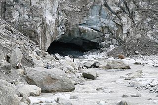
Gomukh, also known as "Gaumukh" or "Gomukhi", is the terminus or snout of the Gangotri Glacier and the source of the Bhagirathi River, one of the primary headstreams of the Ganga River. The word Gomukh/Gaumukh literally means "Mouth of a Cow."

Mount Satopanth (7084m) is one of the prominent peaks of the Garhwal range in the Himalayas, located within the Indian subcontinent. It is also the second highest peak in Gangotri National Park.

Bhagirathi Massif or Bhagirathi Group is a mountain range of Garhwal Himalaya in Gangotri Glacier Uttarakhand India, It has four peaks between 6856 meter and 6193 meter. The Bhagirathi I summits is 6856 meter or 22493 feet. It was first climbed by A Japanese team in 1980. It is surrounded by Glaciers on four side on the eastern side of the Massif is Vasuki Glacier, on the western side its Gangotri Glacier the main glacier in this area, northern side is surrounded by Chaturangi Glacier and southern side guarded by Swachhhand Glacier.

Vasuki Parbat or Vasuki Parvat is a mountain range of Garhwal Himalaya in Vasuki Glacier Uttarakhand, India. It has a subsidiary peak, Vasuki south. Vasuki Parbat stands majestically at 6792 meter and the south peak 6702 at meter. Its the 35th highest located entirely within the uttrakhand India. Nanda Devi, is the highest mountain in this category.
Janhukut is a mountain of Garhwal Himalaya in Uttarakhand India. Janhukut standing majestically at 6805 meter. It's the 31st highest located entirely within the uttrakhand India. Nanda Devi, is the highest mountain in this category. Janhukut is the 473rd highest peak in the world.
Vasuki Parbat South is a mountain of the Garhwal Himalaya in Uttarakhand, India. The elevation of Vasuki Parbat South is 6,702 metres (21,988 ft) and its prominence is 280 metres (919 ft). It is 49th highest located entirely within the Uttrakhand. Nanda Devi, is the highest mountain in this category. It lies 1.6 km south of Vasuki Parbat its nearest higher neighbor 6,792 metres (22,283 ft) and 2.7 km east of Bhagirathi Parbat I 6,856 metres (22,493 ft). It is located 4.6 km SE of Bhagirathi Parbat II 6,512 metres (21,365 ft) and 4.1 km SE lies Satopanth 7,075 metres (23,212 ft).
Bhrigu Parbat is a mountain of the Garhwal Himalaya in Uttarakhand India. It is situated in the Gangotri National Park. The elevation of Bhrigu Parbat is 6,041 metres (19,820 ft). It is joint 167th highest located entirely within the Uttrakhand. Nanda Devi, is the highest mountain in this category. It lies NNW to Manda I 6,491 metres (21,296 ft) its nearest higher neighbor.


