
Pind Dadan Khan Tehsil is a subdivision of Jhelum District, Punjab, Pakistan. It is headquartered at the town of Pind Dadan Khan located on the bank of River Jhelum, about 22 kilometres from the M2 motorway.

Gujar Khan is a city in Rawalpindi District, Punjab, Pakistan. It is the headquarters of Gujar Khan Tehsil, and the largest tehsil of Punjab by land area.

Nasirabad is a district in the centre-west of Balochistan, Pakistan. Nasirabad's headquarters are at Dera Murad Jamali.

Chakwal is the capital and main city of Chakwal District, Punjab, Pakistan. It is located 90 kilometres south-east of the federal capital, Islamabad and 270 kilometres from the provincial capital, Lahore.

Dera Ghazi Khan is a district in the Punjab province of Pakistan. Its capital is Dera Ghazi Khan city.

Rahim Yar Khan District is a district in the Punjab province of Pakistan and the city of Rahim Yar Khan is its capital. The city itself is administratively subdivided into nine Union Councils.
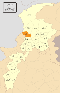
Lower Dir is one of the 26 districts in the Khyber Pakhtunkhwa province of Pakistan. Timergara city is the district headquarters and largest city, while the second largest city is Chakdara. It is a bordering on one side with Bajaur and on the other side with Swat valley and district Malakand with upper part extending Dir Upper connecting Chitral Valley on Northern side.

The Mianwali District, is a district in the northwest of Punjab province, Pakistan. It is border district between Province of Punjab and Khyber Pakhtunkhwa. People of Mianwali understand and share the culture of Khyber Pakhtunkhwa and Punjab. Majority of Mianwalians are belong to the Awan, Khattak and Niazi tribes.

Bhakkar District, is a district in the province of Punjab, Pakistan. The district was created out of parts of Mianwali in 1982 with Bhakkar city as the headquarter and main city. Its area consists of a riverine tract along the Indus, called Kaccha, and most of the district area lies in the desolate plain of the Thal desert.
{{Infobox settlement | official_name = | name = Lodhran District | native_name = ضِلع لودھراں | native_name_lang = | settlement_type = District | image_skyline = | imagesize = | image_alt = | image_caption = | image_map = Punjab Dist Lodharan.svg | mapsize = 200px | map_alt = | map_caption = Map of Punjab with Lodhran District highlighted | latd = |latm = |lats = |latNS = | longd = |longm = |longs = |longEW = | coordinates_type = | coordinates_display = | subdivision_type = Country | subdivision_name = Pakistan | subdivision_type1 = Province | subdivision_name1 = Punjab | founder = | seat_type = Headquarters | seat = Lodhran city | government_footnotes = | leader_party = | unit_pref = Metric | area_footnotes = | area_total_km2 = 1790 | population_footnotes = | population_as_of = 2017 | population_total = 1,700,620 | population_density_km2 = auto | timezone1 = PST | utc_offset1 = +5 | established_title = Established | established_date = | leader_title = Deputy Commissioner (DC) | leader_name = Saqib Ali Ateel | leader_title1 = District Police Officer (DPO) | leader_name1 = Aameer Taimour Khan | blank_name_sec1 = District Council | blank_info_sec1 = | blank1_name_sec1 = Number of Tehsils | blank1_info_sec1 = 3 | demographics1_title1 = Main language(s) | demographics1_info1 = Saraiki [[Punjabi] [Urdu]] | website = lodhran.gop.pk }}

Daultala, is a town and union council located in Gujar Khan Tehsil, Rawalpindi District, Punjab, Pakistan Founder of Daultala is Sultan Shah Daulat Khan Gakhar Son of Sultan Feroz Khan Gakhar, The Town because of Shah Daulat khan Known as "Daulat wala" "دولت والہ" which after some time converts into Daultala, The Current Chairmen of Union Council Daultala is Syed Qualb Abbas ]. MPA PP-9 Chaudhary Sajid Mehmood belongs to Daultala.
Kauntrila (Urdu:کونتريله) is the name of a village and union council of Gujar Khan Tehsil in Rawalpindi District, Punjab, Pakistan.

Pind Kargoo Khan is one of the 51 union councils of Abbottabad District in Khyber-Pakhtunkhwa province of Pakistan. It is located 30 km from Abbottabad city.
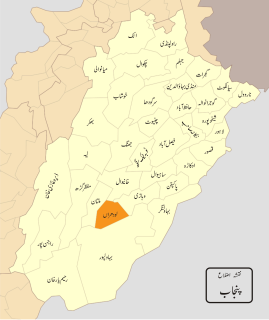
Taunsa is a tehsil (subdivision) of Dera Ghazi Khan District, Punjab, Pakistan. Its capital is Taunsa city.
Rehana is a village and one of the 44 union councils, administrative subdivisions, of Haripur District in the Khyber Pakhtunkhwa province of Pakistan.
Dera Ghazi Khan, is an administrative subdivision (tehsil) of Dera Ghazi Khan District in the Punjab province of Pakistan. The capital of the tehsil is Dera Ghazi Khan.
Dera Ismail Khan Tehsil is a tehsil located in Dera Ismail Khan District, Khyber Pakhtunkhwa, Pakistan.
Kot Chutta, is a tehsil, an administrative subdivision, of Dera Ghazi Khan District in the Punjab Province of Pakistan. It is a part of Dera Ghazi Khan District. Kot Chutta situated at Famous Indus Highway. Chutta Khan Gurmani a trible sardar of Gurmani Lashari Baloch who found this area at the same time when Haji Khan Mirrani settled in Dera Ghazi Khan.
PP-8 (Rawalpindi-III) is a Constituency of Provincial Assembly of Punjab.

