Related Research Articles

Dera Ismail Khan, abbreviated as D.I. Khan, is a city and capital of Dera Ismail Khan District, located in Khyber Pakhtunkhwa, Pakistan. It is the 37th largest city of Pakistan and fifth largest in the province of Khyber Pakhtunkhwa by population. Dera Ismail Khan is situated on the west bank of the Indus River, at its junction with the Gomal River.
Dera Ismail Khan District, often abbreviated as D.I. Khan is a district in the Dera Ismail Khan division of the Khyber Pakhtunkhwa province of Pakistan. The capital of the district is the town of Dera Ismail Khan. The district has an area of 9,334 km2 (3,604 sq mi) and a population of 1,627,132 as of the 2017 Census.

Batala is the eighth largest city in the state of Punjab, India in terms of population after Ludhiana, Amritsar, Jalandhar, Patiala, Bathinda, Mohali and Hoshiarpur. Batala ranks as the second-oldest city after Bathinda. It is a municipal corporation in Gurdaspur district in the Majha region of the state of Punjab. It is located about 32 km from Gurdaspur, the headquarters of the district. It is also a Police district. Batala holds the status of the most populated town of the district with 31% of the district's total population. It is the biggest industrial town in the district.

Jampur is the capital city of Jampur District, in Punjab province of Pakistan. It comprises an area of about 16.7 square kilometers and has a population of about 87,858 (2017) It is the capital of Jampur Tehsil. Approximetly 50km to the west are the high and dry, barren mountains of the Sulaiman Range. To the east is the Indus river.
Layyah District, is a district in the Punjab, Pakistan. It is located in the southern part of the province. Layyah is the district headquarter of Layyah District. Layyah has hot desert climate.

Barkhan is a district in the province of Balochistan in Pakistan. It shares its borders with the province of Punjab to the east and the Balochistan districts of Dera Bugti to the south, Kohlu to the west, Loralai to the northwest and Musakhel to the north. The town of Barkhan serves as the district's headquarters. It was granted the status of a separate district on 31 December 1991, prior to which it was a tehsil within Loralai District.
Mankera, is the principal town of Mankera Tehsil, an administrative subdivision of Bhakkar District, in the Punjab province of Pakistan. It is situated about 320 km (200 mi) west of the city of Lahore.

Qambar Shahdadkot District is a district of Sindh, Pakistan, originally named after Shahdad Khan Khuhawar the official founder. District Qambar Shahdadkot, with headquarters at Qambar, was established on 13 December 2004.
Layyah, previously spelled as Leiah, is a city in Pakistan. The city is headquarter of Layyah District and Layyah Tehsil. It is the 72nd largest city by population in Pakistan.
Shohal Mazullah Khan is a village and union council of Mansehra District in the Khyber-Pakhtunkhwa province of Pakistan. It is located at the bank of River Kuhnar, in the east of the District Mansehra, about 7 km to Balakot and it borders Muzaffarabad District and lies in an area affected by the 2005 Kashmir earthquake.
Kundian, is the 2nd largest city of District Mianwali, tehsil Piplan in the Punjab province of Pakistan. Its population is near 50,000. This is divided into Kundian Katcha & Pacca units with total population of 150,000. Kundian Jn. railway station start operation in August 1887.
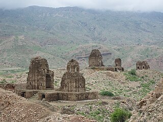
Kafir Kot or Kafirkot is an ancient Hindu temple complex in the Dera Ismail Khan district of the Khyber Pakhtunkhwa province of Pakistan. It consists of the ruins of five temples and a large fort. It was an ancient Hindu fort with a famous temple inside its walls. The Kafir Kot complex in Khyber Pakhtunkhwa is often referred to as the "northern Kafir Kot" to distinguish it from the "southern Kafir Kot" that is located in the town of Bilot Sharif, approximately 35 kilometres (22 mi) to the south.
Khudian Khas, is a large town and Municipal Committee of Kasur District in the Punjab province of Pakistan..Khudian is part of Kasur Tehsil and is at an altitude of 177 meters (583 feet) above sea level. The Sutlej River, which flows on the India-Pakistan border, is 20 kilometers from Khudian. It is 33 kilometers from India-Pakistan border of Ganda Singh Wala All the lines are written and approved by Faheem Jawad a Notable publisher at Khudian khas.
Kot Radha Kishan is a city and Tehsil headquarters of Kot Radha Kishan Tehsil in Kasur District in the Punjab province of Pakistan. The city is administratively subdivided into four Union councils. It was formerly part of Kasur Tehsil and now it has been rewarded with the status of tehsil of district kasur due to the basic necessities of the current time and the mounting population of the area .It is located at 31°10'21N 74°5'59E with an altitude of 193 metres. Kot Radha Kishan is also called 'City of Containers and Leather'.
Bilot Sharif or Bilot is a town and union council of Dera Ismail Khan District in Khyber Pakhtunkhwa province of Pakistan. It is located at 32°15′20″N 71°9′41″E and has an altitude of 180 metres.
Isakhel Tehsil, is an administrative subdivision (tehsil) of Mianwali District in the Punjab province of Pakistan. The city of Isakhel is the headquarters of the tehsil which is administratively subdivided into 3 Municipal Committees 13 Union Councils. It is located between 32° 30′ and 33° 14′ N. and 71° 7′ and 71° 44′ E., with an area of 678 square miles (1,760 km2) and contains the towns of Isakhel, Kammar Mushani and Kalabagh
Kot Ghulam Muhammad is named after Ghulam Muhammad Khan Bhurgri, the Tehsil situated in south-east Mirpur Khas District of the Southern Province Sindh in Pakistan. Kot Ghlam Muhammad Bhurgri is situated west of Samaro and north of Digri. It is about 45 kilometres (28 mi) south of Mirpur Khas.
Kot Suleman is small part of village Dhoong near village Trati in Union Council Narali located in Gujar Khan Tehsil, District Rawalpindi, Punjab, Pakistan. It has a population of 250. Kot Suleman is a historic town of Village Dhoong, Rawalpindi District. Kot Suleman is famous for its natural reserves of oil and natural gas.
Kotla Mughlan is a union council of Jampur Tehsil, Rajanpur District, Pakistan.
Kallur kot, is a town in Bhakkar District in the Punjab Province of Pakistan.