Related Research Articles

Pulaski County is a county in the U.S. Commonwealth of Kentucky. As of the 2020 census, the population was 65,034. Its county seat is Somerset. The county was founded in December 1798 from land given by Lincoln and Green Counties and named for Polish patriot Count Casimir Pulaski. Pulaski County comprises the Somerset, KY Micropolitan Statistical Area. Somerset's population is just over 11,000, but the Micropolitan Area for Somerset/Pulaski County is over 65,000.

Jackson County is located in the Commonwealth of Kentucky. As of the 2020 census, the population was 12,955. Its county seat is McKee. The county was formed in 1858 from land given by Madison, Estill, Owsley, Clay, Laurel, and Rockcastle counties. It was named for Andrew Jackson, seventh President of the United States. Jackson County became a moist county via a "local-option" referendum in the Fall of 2019 that made the sale of alcoholic beverages in the county seat, McKee, legal.

Somerset is a home rule-class city in Pulaski County, Kentucky, United States. The city population was 11,924 according to the 2020 census. It is the seat of Pulaski County.

Eubank is a home rule-class city in Pulaski and Lincoln counties in southern Kentucky. The population was 319 at the 2010 census.
The Red River is a 97.2-mile-long (156.4 km) tributary of the Kentucky River in east-central Kentucky in the United States. Via the Kentucky and Ohio rivers, it is part of the Mississippi River watershed.

The Gasconade River is about 280 miles (450 km) long and is located in central and south-central Missouri.

Mill Springs National Cemetery is a United States National Cemetery located in the town of Nancy, eight miles (13 km) west of the city of Somerset in Pulaski County, Kentucky. Administered by the United States Department of Veterans Affairs, it encompasses 6.3 acres (2.5 ha), and as of 2014, has over 4,000 interments.

The Nolin River is a 104-mile-long (167 km) tributary of the Green River in central Kentucky in the United States. Via the Green and Ohio rivers, it is a part of the watershed of the Mississippi River.
Tygarts Creek is a tributary of the Ohio River in Carter and Greenup counties of northeastern Kentucky in the United States. It is 88 miles (142 km) long and drains an area of 339.6 square miles (880 km2). Via the Ohio, it is part of the watershed of the Mississippi River. Tygarts Creek is named for early Kentucky explorer Michael Tygart, who eventually drowned in the creek, somewhere near the mouth.

The Licking River is a partly navigable, 303-mile-long (488 km) tributary of the Ohio River in northeastern Kentucky. The river and its tributaries drain much of the region of northeastern Kentucky between the watersheds of the Kentucky River to the west and the Big Sandy River to the east. The North Fork Licking River, in Pendleton County, Kentucky, is one of its tributaries. The South Fork Licking River, in counties including Harrison County, Kentucky, is another.
Copper Mine Gulch is a valley in Marin County, California, United States, which is associated with a small stream.
Alpine Creek is a small river in San Mateo County, California. It flows about 5 miles (8 km), from its source near West Alpine Road about a mile southwest of Skyline Boulevard (CA 35), to its confluence with La Honda Creek to form San Gregorio Creek in La Honda at California State Route 84.
Sweeden is an unincorporated community in north-central Edmonson County, Kentucky, United States. The population of Sweeden's ZCTA was 171 at the 2000 census. It is part of the Bowling Green, Kentucky Metropolitan Statistical Area. The ZIP Code for Sweeden is 42285.

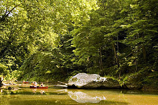
A karst window, also known as a karst fenster, is a geomorphic feature found in karst landscapes where an underground river is visible from the surface within a sinkhole. In this feature, a spring emerges, then the discharge abruptly disappears into a sinkhole. The word fenster is German for 'window', as these features are windows into the karst landscape.
Ringgold is an unincorporated community in Pulaski County, in the U.S. state of Kentucky.
Ruth is an unincorporated community in Pulaski County, in the U.S. state of Kentucky.
Reedyville is an Unincorporated community in Butler County, Kentucky, United States. The town is supposedly named for the nearby Big Reedy Creek, a tributary of the Green River.
References
- 1 2 "Short Creek". Geographic Names Information System . United States Geological Survey, United States Department of the Interior . Retrieved May 5, 2021.
- ↑ Mardis, Bill (April 3, 2019). "There are mystical marvels right here in Pulaski County". Commonwealth Journal . Somerset, Ky. Retrieved April 19, 2021.
- ↑ "Short Creek in Pulaski County KY". Kentucky.hometownlocator.com. HomeTownLocator. 2021. Retrieved April 18, 2021.
- ↑ "Pulaski County, Kentucky". kgs.uky.edu. University of Kentucky . Retrieved April 18, 2021.