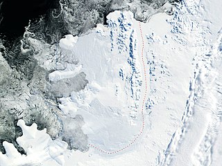
Alexander Island, which is also known as Alexander I Island, Alexander I Land, Alexander Land, Alexander I Archipelago, and Zemlja Alexandra I, is the largest island of Antarctica. It lies in the Bellingshausen Sea west of Palmer Land, Antarctic Peninsula from which it is separated by Marguerite Bay and George VI Sound. The George VI Ice Shelf entirely fills George VI Sound and connects Alexander Island to Palmer Land. The island partly surrounds Wilkins Sound, which lies to its west. Alexander Island is about 390 kilometres (240 mi) long in a north–south direction, 80 kilometres (50 mi) wide in the north, and 240 kilometres (150 mi) wide in the south. Alexander Island is the second-largest uninhabited island in the world, after Devon Island.

Thurston Island is a largely ice-covered, glacially dissected island, 135 nautical miles long and 55 nautical miles wide, lying between Amundsen Sea and Bellingshausen Sea a short way off the northwest end of Ellsworth Land, Antarctica. The island is separated from the mainland by Peacock Sound, which is occupied by the west portion of Abbot Ice Shelf.
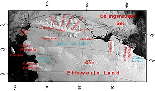
The Abbot Ice Shelf is an ice shelf 250 nautical miles long and 40 nautical miles wide, bordering Eights Coast from Cape Waite to Pfrogner Point in Antarctica. Thurston Island lies along the northern edge of the western half of this ice shelf; other sizable islands lie partly or wholly within this shelf.

The Getz Ice Shelf is an ice shelf over 300 nautical miles long and from 20 to 60 nautical miles wide, bordering the Hobbs Coast and Bakutis Coast of Marie Byrd Land, Antarctica, between the McDonald Heights and Martin Peninsula. Several large islands are partially or wholly embedded in the ice shelf.

The Beethoven Peninsula is a deeply indented, ice-covered peninsula, 60 miles (100 km) long in a northeast–southwest direction and 60 miles (100 km) wide at its broadest part, forming the southwest part of Alexander Island, which lies off the southwestern portion of the Antarctic Peninsula. The south side of the peninsula is supported by the Bach Ice Shelf whilst the north side of the peninsula is supported by the Wilkins Ice Shelf. The Mendelssohn Inlet, the Brahms Inlet and the Verdi Inlet apparently intrude into it. The Bach Ice Shelf, Rossini Point and Berlioz Point are some distance away, on the Ronne Entrance from the Southern Ocean. Beethoven Peninsula is one of the eight peninsulas of Alexander Island.
Mawson Peninsula is a high, narrow, ice-covered peninsula on the George V Coast, on the west side of the Slava Ice Shelf, Antarctica, terminating in Cape Hudson. It extends for over 30 nautical miles (56 km) in a northwesterly direction. The peninsula was photographed from the air by U.S. Navy Operation Highjump, 1946–47, and was sketched and photographed by Phillip Law of the Australian National Antarctic Research Expeditions who flew along it to its northern end in February 1959. It was named by the Antarctic Names Committee of Australia for Sir Douglas Mawson.
Lazarev Bay is a rectangular bay, 15 nautical miles (28 km) long and 13 nautical miles (24 km) wide, which separates Alexander Island from Rothschild Island and is bounded on the south side by the Wilkins Ice Shelf, which joins the east portion of Rothschild Island and the west portion of Alexander Island. Two minor islands, Dint Island and Umber Island, lie merged within the ice of the Wilkins Ice Shelf within Lazarev Bay.
The George VI Ice Shelf is an extensive ice shelf that occupies George VI Sound which separates Alexander Island from Palmer Land in Antarctica. The ice shelf extends from Ronne Entrance, at the southwest end of the sound, to Niznik Island, about 30 nautical miles (56 km) south of the north entrance between Cape Brown and Cape Jeremy. It was named by the UK Antarctic Place-Names Committee in association with George VI Sound.
Boccherini Inlet is an ice-filled inlet, 18 nautical miles (33 km) long and 16 nautical miles (30 km) wide, lying between Bennett Dome and Shostakovich Peninsula, which indents the south side of Beethoven Peninsula and forms the northern extremity of the Bach Ice Shelf in Alexander Island. It was first mapped from air photos taken by the Ronne Antarctic Research Expedition, 1947–48, by Derek J.H. Searle of the Falkland Islands Dependencies Survey in 1960, and named by the UK Antarctic Place-Names Committee for Luigi Boccherini, the Italian composer.
The Ceres Nunataks are a group of three nunataks located immediately east of the base of Shostakovich Peninsula in southern Alexander Island, Antarctica. They were mapped by the Directorate of Overseas Surveys from satellite imagery supplied by the U.S. National Aeronautics and Space Administration in cooperation with the U.S. Geological Survey, and named by the UK Antarctic Place-Names Committee after Ceres, one of the asteroids lying between the orbits of the planets Mars and Jupiter.
Condor Peninsula is a mountainous, ice-covered peninsula, 30 nautical miles long and 10 to 15 nautical miles wide, between Odom Inlet and Hilton Inlet on the east coast of Palmer Land, Antarctica.
Stravinsky Inlet is an ice-covered inlet lying between Shostakovich Peninsula and Monteverdi Peninsula in southern Alexander Island, Antarctica. The inlet was first mapped by Directorate of Overseas Surveys from satellite imagery supplied by U.S. National Aeronautics and Space Administration in cooperation with U.S. Geological Survey. Named by United Kingdom Antarctic Place-Names Committee after Igor Stravinsky (1882–1971), Russian-born composer who became a French citizen, ultimately a citizen of the United States.
Eroica Peninsula is an ice-covered peninsula lying north of Beethoven Peninsula and Mendelssohn Inlet in western Alexander Island, Antarctica. The tip of the peninsula is Kosar Point, marking the western extremity of the Eroica Peninsula. It was mapped from trimetrogon air photography taken by the Ronne Antarctic Research Expedition, 1947–48, and from survey by the Falkland Islands Dependencies Survey, 1948–50. It was named by the UK Antarctic Place-Names Committee after Beethoven's Eroica symphony, in association with Beethoven Peninsula. Eroica Peninsula is one of the eight peninsulas of Alexander Island.
Gluck Peak is a rock peak, 335 metres (1,100 ft) high, located 6.5 nautical miles (12 km) south-southwest of Mount Borodin and immediately north of Alyabiev Glacier, lying between the bases of Bennett Dome and Shostakovich Peninsula on south side of the Beethoven Peninsula, southwest Alexander Island, Antarctica. It was first mapped — from air photos taken by the 1947–48 Ronne Antarctic Research Expedition — by D. Searle of the Falkland Islands Dependencies Survey in 1960, and was named by the UK Antarctic Place-Names Committee after Christoph Willibald von Gluck, the Austrian composer (1714-1787).
Mendelssohn Inlet is an ice-filled inlet, 25 nautical miles (46 km) long and 9 nautical miles (17 km) wide, situated between Derocher Peninsula and Eroica Peninsula on the north side of Beethoven Peninsula, in the southwest part of Alexander Island, Antarctica. The inlet was first sighted from the air and roughly mapped by the United States Antarctic Service, 1939–41, and was resighted and photographed from the air by the Ronne Antarctic Research Expedition (RARE), 1947–48. It was remapped from the RARE photos by D. Searle of the Falkland Islands Dependencies Survey in 1960, and named by the UK Antarctic Place-Names Committee after German composer Felix Mendelssohn.
Stephenson Nunatak is a prominent, pyramid-shaped rock nunatak, rising to about 640 m, which rises 300 m above the surrounding ice at the northwest side of Kirwan Inlet in the southeast part of Alexander Island, Antarctica. Discovered and roughly surveyed in 1940-41 by Finn Ronne and Carl R. Eklund of the United States Antarctic Service. Resurveyed in 1949 by the Falkland Islands Dependencies Survey and named by the United Kingdom Antarctic Place-Names Committee for Alfred Stephenson, surveyor with the British Graham Land Expedition, who led a sledge party south into George VI Sound to about 72S in 1936. There happens to be another landform on Alexander Island which is named after Alfred Stephenson, that being Mount Stephenson, the highest point of Alexander Island rising to 2,987 m.
Holoviak Glacier is a glacier flowing west into the head of Mendelssohn Inlet, facing towards the Wilkins Ice Shelf on the north side of the Beethoven Peninsula, lying in the southwestern portion of Alexander Island, Antarctica. It was mapped by the United States Geological Survey from U.S. Navy aerial photographs taken 1967–68 and from Landsat imagery taken 1972–73, and was named by the Advisory Committee on Antarctic Names for Judy C. Holoviak, technical editor, 1964–77, of the Antarctic Research Series, published by the American Geophysical Union, and director of publications for the Union from 1978.
Lewis Snowfield is a low and undulating snowfield lying south of Holoviak Glacier and east of the Franck Nunataks in the southwest portion of Alexander Island, Antarctica. It extends westward from the Walton Mountains to the Beethoven Peninsula and northward from the Bach Ice Shelf to the Wilkins Ice Shelf. The snowfield was named by the UK Antarctic Place-Names Committee for Ernest G. Lewis, Governor of the Falkland Islands, 1971–74.
Alyabiev Glacier is a glacier in Antarctica, flowing south from Gluck Peak into Boccherini Inlet and lies about 3 miles (5 km) West of Arensky Glacier on Beethoven Peninsula, Alexander Island, It was named by the USSR Academy of Sciences, in 1987, after Alexander Alyabiev (1787-1851), the Russian composer.