Shughnon District

Last updated
Shughnon District
Russian: Шугнанский район
Tajik: Ноҳияи Шуғнон
Shughnon District in Tajikistan.svg
Location of Shughnon District in Tajikistan
Coordinates: 37°35′N71°45′E / 37.583°N 71.750°E / 37.583; 71.750
Country Flag of Tajikistan.svg Tajikistan
Region Gorno-Badakhshan Autonomous Region
Capital Vahdat
Area
  Total
4,600 km2 (1,800 sq mi)
Population
 (2020) [1]
  Total
38,000
  Density8.3/km2 (21/sq mi)
Time zone UTC+5 (TJT)
Postal code
736100
Area code +992 355
Official languages
Website shugnon.tj
Friendship Bridge between Afghanistan and Tajikistan across the river Panj in Shughnon District Bridge shughnan tj & shughnan af.jpg
Friendship Bridge between Afghanistan and Tajikistan across the river Panj in Shughnon District
A view of the Panj, the border between Afghanistan and Tajikistan in Shughnon District Beautiful view of Panj river, of the border between Afghanistan and Tajikistan the in Shughnon-shughnan region.jpg
A view of the Panj, the border between Afghanistan and Tajikistan in Shughnon District

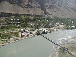
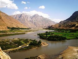
Shughnon District [a] is a district in eastern Tajikistan, in the central-western part of Gorno-Badakhshan Autonomous Region (GBAO). It is bordered by the river Panj and Afghanistan on the west, the Rushan Range and Rushon District on the north, Murghob District on the east and the Shughnon Range and Roshtqal'a District on the south. It corresponds to the valley of the river Gunt. [3] The district seat is the village Vahdat. [4] The population of Shughnon District is 38,000 (1 January 2020 estimate). [1]

Contents

Administrative divisions

The district has an area of about 4,600 km2 (2,000 sq mi) and is divided administratively into seven jamoats. [5] They are as follows: [6]

JamoatPopulation (Jan. 2015) [6]
Navobod 6,864
Porshinev 8,723
Shahbozov (Darmorakht)2,759
Shirinjonov (Sokhcharv)2,932
Suchon 8,436
Vanqal'a 5,575
Ver 4,891

Notes

  1. Russian: Шугнанский район, IPA: [ʂʊgˈnanskʲɪjrɐˈjɵn] ; Tajik: Ноҳияи Шуғнон, romanized: Nohiyayi Shug‘non, IPA: [nɔhɪˈjaɪʃʊʁˈnɔn] ; Shughni: Хуг̌ну̊н ноийа, romanized: Xuɣ̌nůn noiya, pronounced [χʊɣˈnɵnnɔɪˈja]

References

  1. 1 2 "Population of the Republic of Tajikistan as of 1 January 2020" (PDF) (in Russian). Statistics office of Tajikistan. Retrieved 3 October 2020.
  2. "КОНСТИТУЦИЯ РЕСПУБЛИКИ ТАДЖИКИСТАН". prokuratura.tj. Parliament of Tajikistan. Retrieved 9 January 2020.
  3. Republic of Tajikistan, map showing administrative division as of January 1, 2004, "Tojikkoinot" Cartographic Press, Dushanbe
  4. Official website Shughnon District, "Марказ: шаҳраки Ваҳдат"
  5. "Regions of the Republic of Tajikistan 2017" (PDF) (in Russian). Statistics office of Tajikistan. pp. 15–21. Retrieved 12 October 2020.
  6. 1 2 Jamoat-level basic indicators, United Nations Development Programme in Tajikistan, accessed 3 October 2020