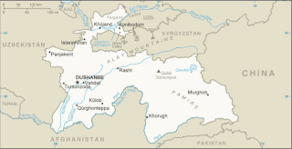
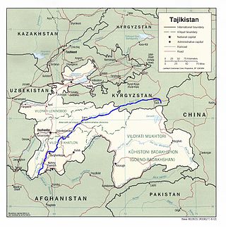
Tajikistan is nestled between Kyrgyzstan and Uzbekistan to the north and west, China to the east, and Afghanistan to the south. Mountains cover 93 percent of Tajikistan's surface area. The two principal ranges, the Pamir Mountains and the Alay Mountains, give rise to many glacier-fed streams and rivers, which have been used to irrigate farmlands since ancient times. Central Asia's other major mountain range, the Tian Shan, skirts northern Tajikistan. Mountainous terrain separates Tajikistan's two population centers, which are in the lowlands of the southern and northern sections of the country. Especially in areas of intensive agricultural and industrial activity, the Soviet Union's natural resource utilization policies left independent Tajikistan with a legacy of environmental problems.
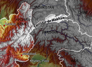
The Wakhan Corridor is a narrow strip of territory in the Badakhshan province of Afghanistan. This corridor stretches eastward, connecting Afghanistan to Xinjiang, China. It also separates the Gorno-Badakhshan Autonomous Region of Tajikistan in the north from the Khyber Pakhtunkhwa and Gilgit-Baltistan regions of Pakistan in the south, the latter of which is also part of the disputed region of Kashmir. This high mountain valley, which rises to a maximum altitude of 4,923 m (16,152 ft), serves as the source of both the Panj and Pamir rivers, which converge to form the larger Amu Darya River. For countless centuries, a vital trade route has traversed this valley, facilitating the movement of travelers to and from East, South, and Central Asia.
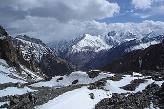
The Pamir Mountains are a range of mountains between Central Asia and South Asia. They are located at a junction with other notable mountains, namely the Tian Shan, Karakoram, Kunlun, Hindu Kush and the Himalaya mountain ranges. They are among the world's highest mountains.
The Pamir languages are an areal group of the Eastern Iranian languages, spoken by numerous people in the Pamir Mountains, primarily along the Panj River and its tributaries.
The Zarafshon is a river in Tajikistan and Uzbekistan in Central Asia. Its name, "spreader of gold" in Persian, refers to the presence of gold-bearing sands in the upper reaches of the river. To the ancient Greeks it was known as the Polytimetus. It was also formerly known as Sughd River. The river is 877 kilometres (545 mi) long and has a basin area of 17,700 square kilometres (6,800 sq mi).
The Vakhsh, also known as the Surkhob in north-central Tajikistan and as the Kyzyl-Suu in Kyrgyzstan, is a Central Asian river and one of the main rivers of Tajikistan. It is a tributary of the Amu Darya river.
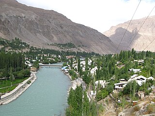
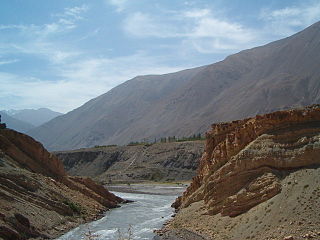
The Gunt is a river in the south of Tajikistan, north of the Shughnon Range. It is 296 kilometres (184 mi) long and has a basin area of 13,700 square kilometres (5,300 sq mi). Its source, Lake Yashilkul, is situated at the edge of the Alichur Pamir, a high plateau or pamir at an elevation of 3,720 m. The city of Khorog is located at the confluence of the Gunt with the Panj. See Gorno-Badakhshan Autonomous Region for surrounding area.

The Bartang is a river of Central Asia, and is a tributary to the Panj which itself is a tributary to the Amu Darya. In its upper reaches, it is also known as the Murghab and Aksu; it flows through the Wakhan in Afghanistan, then through the Rushon District of the Gorno-Badakhshan autonomous region, Tajikistan. The river is 528 kilometres (328 mi) long and has a basin area of 24,700 square kilometres (9,500 sq mi).
The Yazghulom is a river in Vanj district, western Gorno-Badakhshan, Tajikistan. It is a right tributary of the Panj. The river is 80 kilometres (50 mi) long and has a basin area of 1,970 square kilometres (760 sq mi).

Vanj is a village and jamoat in Gorno-Badakhshan Autonomous Region, Tajikistan. It is the seat of the Vanj District. Vanj lies on the lower course of the river Vanj, a tributary of the Panj, separated from the Yazgulem to the south by the Vanj Range. The jamoat, which is also called Abdulloev, has a total population of 11,217 (2015).

The Vanch-Yakh Glacier is a large glacier in the Yazgulem Range, Pamir Mountains, of north-central Gorno-Badakhshan province, Tajikistan. The glacier is long and narrow, currently extending for 77 kilometres (48 mi) and covering over 700 square kilometres (270 sq mi). It is the longest glacier in the world outside of the polar regions. The maximum thickness of the glacier is 1,000 metres (3,300 ft), and the volume of the glacier and its dozens of tributaries is estimated at 144 cubic kilometres (35 cu mi)—about a third of the volume of Lake Erie.

Vanj District or Nahiya-e Vanj is a district in eastern Tajikistan, in the north-west of the Gorno-Badakhshan Autonomous Region, with administrative capital Vanj.

Roshtqal'a District is a district in eastern Tajikistan, in the south-western part of the Gorno-Badakhshan Autonomous Region (GBAO). It stretches along the river Shakhdara between the Shughnon Range to the north and the Shakhdara Range to the south, enclosed within GBAO, without international borders. The population of Roshtqal'a district is 27,400. Its administrative capital is the village Roshtqal'a in the west part of the district, about 30 km south-east of the regional capital Khorugh.

The Tajikistan–Afghanistan Friendship Bridge connects the two banks of Darvaz region across the Panj River separating Tajikistan and Afghanistan, at the town of Qal'ai Khumb. It was opened on 6 July 2004.

The Kofarnihon is one of the major tributaries of the Amu Darya in Tajikistan. The river is 387 kilometres (240 mi) long and has a basin area of 11,600 square kilometres (4,500 sq mi). It rises on the southern slopes of Gissar Range in Vahdat district, formerly Kofarnihon district, and flows in the general south-western direction past the cities of Vahdat and Dushanbe, where it turns south and runs through Khatlon Province toward the border with Afghanistan. It falls into Amudarya some 40 km west of the confluence point of Vakhsh and Panj rivers. The Kofarnihon is an important source of drinking water, and yet it is highly polluted by irrigation runoff and inadequately cleaned recycled water around the cities of Dushanbe and Vahdat.
The Qizilsu or Kyzylsu is a river that rises on the southern slopes of the Vakhsh Range in the north-east of Tajikistan's Khatlon Region and runs south-west until joining the Panj on the border with Afghanistan. The river is 230 kilometres (140 mi) long and has a basin area of 8,630 square kilometres (3,330 sq mi). It merges with the Yakhsu (Akhshu) as a major left tributary south of the town of Kulob. It irrigates the cotton-growing Qizilsu Valley between Kulob and Panj in the south-east of Khatlon Province. It is not the Kyzyl-Suu River that rises in Kyrgyzstan and flows through Tajikistan as Surkhob, then Vakhsh, following a course north-west of Qizilsu.
The Vanj Range is a mountain range of Vanj district, Gorno-Badakhshan, Tajikistan.
The Muksu is a west-flowing river in northeastern Tajikistan. It is a tributary of the Vakhsh which in turn is a tributary of the Amu Darya. The river is 88 kilometres (55 mi) long and has a basin area of 7,070 square kilometres (2,730 sq mi). It is formed at the confluence of the rivers Seldara and Sauksay, near Altyn Mazar. The north side of its valley is the Trans-Alay Range and the south side is formed by the Peter I Range and the Academy of Sciences Range. It joins the Kyzyl-Suu to form the Surkhob or Vakhsh. At Altyn Mazar there is a pass leading north to Daroot-Korgon in the Alay Valley.

The Zarafshan Range, formerly the Zeravshan Range, is a mountain range in Tajikistan and Uzbekistan, part of the Pamir-Alay mountains. Almost all of the range belongs to the drainage basins of the Zarafshan River.
The Darvoz Range or Darvaz Range is a mountain range in the Western Pamirs, in Gorno-Badakhshan Autonomous Region of Tajikistan. Its name derives from the historical region of Darvaz.

