
Southeast Alaska, often abbreviated to Southeast or Southeastern, and sometimes called the Alaska(n) Panhandle, is the southeastern portion of the U.S. state of Alaska, bordered to the east and north by the northern half of the Canadian province of British Columbia. The majority of Southeast Alaska is situated in Tlingit Aaní, much of which is part of the Tongass National Forest, the United States' largest national forest. In many places, the international border runs along the crest of the Boundary Ranges of the Coast Mountains. The region is noted for its scenery and mild, rainy climate.

Kodiak Island Borough is a borough in the U.S. state of Alaska. At the 2020 census, the population was 13,101, down from 13,592 in 2010. The borough seat is Kodiak.

Lake and Peninsula Borough is a borough in the state of Alaska. As of the 2020 census, the population was 1,476, down from 1,631 in 2010. The borough seat of King Salmon is located in neighboring Bristol Bay Borough, although is not the seat of that borough. The most populous community in the borough is the census-designated place of Port Alsworth. With an average of 0.017 inhabitants per square kilometre, the Lake and Peninsula Borough is the second least densely populated organized county-equivalent in the United States; only the unorganized Yukon-Koyukuk Census Area has a lower density.
Aleneva is a census-designated place in the Kodiak Island Borough in the U.S. state of Alaska. As of the 2010 census, the population was 37, down from 68 in 2000.
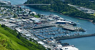
The City of Kodiak is the main city and one of seven communities on Kodiak Island in Kodiak Island Borough, Alaska. All commercial transportation between the island's communities and the outside world goes through this city via ferryboat or airline. As of the 2020 census, the population of the city is 5,581, down from 6,130 in 2010. It is the tenth-largest city in Alaska.
Kodiak Station is a census-designated place (CDP) in Kodiak Island Borough, Alaska, United States. At the 2020 census the population was 1,673, up from 1,301 in 2010.

Port Lions is a city located on Kodiak Island in the Kodiak Island Borough of the U.S. state of Alaska. As of the 2010 census, the population of the city was 194, down from 256 in 2000.

Kodiak Island is a large island on the south coast of the U.S. state of Alaska, separated from the Alaska mainland by the Shelikof Strait. The largest island in the Kodiak Archipelago, Kodiak Island is the second largest island in the United States and the 80th largest island in the world, with an area of 3,595.09 sq mi (9,311.2 km2), slightly larger than Cyprus. It is 160 km long and in width ranges from 16 to 97 kilometers. Kodiak Island is the namesake for Kodiak Seamount, which lies off the coast at the Aleutian Trench. The largest community on the island is the city of Kodiak, Alaska.

Afognak is an island in the Kodiak Archipelago 5 km (3.1 mi) north of Kodiak Island in the U.S. state of Alaska. It is 43 miles (69 km) long from east to west and 23 miles (37 km) wide from north to south and has a land area of 1,812.58 km2 (699.84 sq mi), making it the 18th largest island in the United States. The coast is split by many long, narrow bays. The highest point is 2,546 feet (776 m).
The Kodiak Archipelago is an archipelago south of the main land-mass of the state of Alaska, about 405 km (252 mi) by air south-west of Anchorage in the Gulf of Alaska. The largest island in the archipelago is Kodiak Island, the second-largest island in the United States. The archipelago has a length of about 285 km (177 mi) and a width of about 108 km (67 mi), from the Barren Islands on the north to Chirikof Island and the Semidi Islands group on the south. The archipelago contains 13,890 km2 (5,360 sq mi) of land. The Kodiak Archipelago contains about 40 small glaciers, numerous streams and many species of land and marine animals. Much of its land is forested.
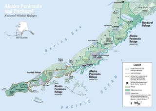
The Alaska Peninsula is a peninsula extending about 497 mi (800 km) to the southwest from the mainland of Alaska and ending in the Aleutian Islands. The peninsula separates the Pacific Ocean from Bristol Bay, an arm of the Bering Sea.
Afognak (; also Agw'aneq in Alutiiq was an Alutiiq village on the island of Afognak in Kodiak Island Borough, Alaska, United States. It was located on Afognak Bay on the southwest coast of the island, three miles north of Kodiak Island. The site is now within the CDP of Aleneva.

Southwest Alaska is a region of the U.S. state of Alaska. The area is not exactly defined by any governmental administrative region(s); nor does it always have a clear geographic boundary.

Tugidak Island is an island of the Kodiak Archipelago in Kodiak Island Borough, Alaska, United States. It lies southwest of the southern tip of Kodiak Island in the western part of the Gulf of Alaska. Sitkinak Island lies to its east. The two islands are the largest components of the Trinity Islands of Alaska. The Trinity Islands, and thus Tugidak, are part of the Gulf of Alaska unit of Alaska Maritime National Wildlife Refuge. Tugidak Island has a land area of 173.142 km2 and no resident population. The most prominent feature of the island is the large shallow lagoon near its northeastern end. This part of the island was established as the Tugidak Island Critical Habitat Area by the state of Alaska in 1998 as a wildlife conservation area, and is managed by the Alaska Department of Fish and Game. The island has historically been known as a nesting spot for harbor seals as well as many species of marine birds.
Whale Island is an island of the Kodiak Archipelago in the Gulf of Alaska in Kodiak Island Borough, Alaska, United States. It lies off the northern end of Kodiak Island, between it and Afognak Island to the north. It is separated from Kodiak Island by Whale Pass, and from Afognak Island by Afognak Strait. Raspberry Island lies to the west, while Spruce Island lies to the east. Whale Island has a land area of 39.235 km2 and is unpopulated.
Marmot Island is an island of the Kodiak Archipelago in the Gulf of Alaska in the U.S. state of Alaska. It is part of Kodiak Island Borough and lies east of Afognak Island. The island has a land area of 45.196 km2 and is unpopulated.
Port Williams Seaplane Base is a public use seaplane base located in Port Williams, in the Kodiak Island Borough of the U.S. state of Alaska. Port William is located on the southern tip of Shuyak Island, facing Afognak Island, about 45 miles north of Kodiak.

Raspberry Island is an island of the Kodiak Archipelago located in the Gulf of Alaska in the U.S. state of Alaska. It is located two miles northwest of Whale Island, and just across the mile-wide Raspberry Strait from the southwestern end of Afognak. The island is separated from Kodiak Island by the Kupreanof Strait, with the Shelikof Strait to the northwest. Raspberry Island is 18 miles (29 km) long with a width that varies from 3 miles (4.8 km) to 8 miles (12.9 km). The highest point on the island is 3,300 ft.
Port Wakefield is a ghost town in the U.S. state of Alaska. It is located on the northeast coast of Raspberry Island in the Kodiak Archipelago, along the western shores of the Gulf of Alaska.
The Barren Islands (Sugpiaq: Usu'unaat) are an archipelago in Alaska in the United States. They are the northernmost islands of the Kodiak Archipelago. The largest island of the group is Ushagat Island. The islands have a combined land area of 16.23 square miles (42.0 km2) and are uninhabited. The largest breeding grounds of seabirds in Alaska are located in the Barren Islands on East Amatuli Island and Nord Island. The archipelago is part of the Alaska Maritime National Wildlife Refuge.

