
The Kariba Dam is a double curvature concrete arch dam in the Kariba Gorge of the Zambezi river basin between Zambia and Zimbabwe. The dam stands 128 metres (420 ft) tall and 579 metres (1,900 ft) long. The dam forms Lake Kariba, which extends for 280 kilometres (170 mi) and holds 185 cubic kilometres (150,000,000 acre⋅ft) of water.

The Zambezi River is the fourth-longest river in Africa, the longest east-flowing river in Africa and the largest flowing into the Indian Ocean from Africa. The area of its basin is 1,390,000 square kilometres (540,000 sq mi), slightly less than half of the Nile's. The 2,574-kilometre-long river (1,599 mi) arises in Zambia and flows through eastern Angola, along the north-eastern border of Namibia and the northern border of Botswana, then along the border between Zambia and Zimbabwe to Mozambique, where it crosses the country to empty into the Indian Ocean.

Victoria Falls is a waterfall on the Zambezi River in southern Africa, which provides habitat for several unique species of plants and animals. It is located on the border between Zambia and Zimbabwe and is considered to be one of the world's largest waterfalls due to its width of 1,708 m (5,604 ft).

Lake Kariba is the world's largest man-made lake and reservoir by volume. It lies 1,300 kilometres (810 mi) upstream from the Indian Ocean, along the border between Zambia and Zimbabwe. Lake Kariba was filled between 1958 and 1963 following the completion of the Kariba Dam at its northeastern end, flooding the Kariba Gorge on the Zambezi River.
Hwange National Park is the largest natural reserve in Zimbabwe. The park lies in the west, on the main road between Bulawayo and the Victoria Falls and near to Dete.

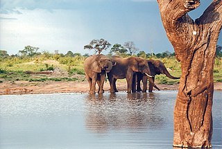
Matusadona National Park is a national park in northern Zimbabwe situated on the southern shore of Lake Kariba. The park takes its name from the local Matuzviadonha Hills.

Zimbabwe Parks and Wildlife Management Authority (Zimparks) is an agency of the Zimbabwe government managing national parks. Zimbabwe's game reserves are managed by the government. They were initially founded as a means of using unproductive land.
Chizarira National Park lies in Northern Zimbabwe. At 2,000 square kilometres, it is the third-largest national park in Zimbabwe, and also one of the least known because of its isolated situation on the Zambezi Escarpment. It has good wildlife populations and some majestic scenery. The name of the park comes from the Batonga word chijalila, which translates into English as "great barrier", referring to Zambezi Escarpment, of which Chizarira’s rough terrain forms a part.
Kariba is a district and constituency on the shores of Lake Kariba in the Mashonaland West Province of northern Zimbabwe, along the border with Zambia. The constituency comprises 12 rural wards or municipalities in Kariba Rural, also known as Nyaminyami Rural District, and 9 urban wards in Kariba Town, the district capital. The district's total population was just under 60,000 in 2011. Kariba town was built to house the workers who built Kariba Dam, which was completed in 1960 to supply Zimbabwe and Zambia with hydroelectric power, and which gave rise to one of the largest artificial lakes in the world. The creation of the Kariba Lake led to a thriving fishing industry, but following Zimbabwe's economic collapse, Kariba became the least developed district in the country. Kariba is also the most isolated district in Zimbabwe, with no tarred roads as of 2002. The main economic activities are subsistence agriculture, fishing and subsistence hunting. The district, which includes Matusadona National Park, suffers from high levels of wildlife poaching and high levels of human-wildlife conflict.

Mana Pools National Park is a 219,600 ha wildlife conservation area and national park in northern Zimbabwe. It is a region of the lower Zambezi River in Zimbabwe where the flood plain turns into a broad expanse of lakes after each rainy season. As the lakes gradually dry up and recede, the region attracts many large animals in search of water, making it one of Africa's most renowned game-viewing regions.

Vulcanodon is an extinct genus of sauropod dinosaur from the Early Jurassic of southern Africa. The only known species is V. karibaensis. Discovered in 1969 in Rhodesia, it was regarded as the earliest-known sauropod for decades, and is still one of the most primitive sauropods that has been discovered. As a quadrupedal, ground-dwelling herbivore, Vulcanodon already showed the typical sauropod body plan with column-like legs and a long neck and tail. It was smaller than most other sauropods, measuring approximately eleven metres (36 ft) in length. Vulcanodon is known from a fragmentary skeleton including much of the pelvic girdle, hindlimbs, forearms, and tail, but lacking the trunk and neck vertebrae as well as the skull.

The Karoo Supergroup is the most widespread stratigraphic unit in Africa south of the Kalahari Desert. The supergroup consists of a sequence of units, mostly of nonmarine origin, deposited between the Late Carboniferous and Early Jurassic, a period of about 120 million years.

Wildlife tourism is an element of many nations' travel industry centered around observation and interaction with local animal and plant life in their natural habitats. While it can include eco- and animal-friendly tourism, safari hunting and similar high-intervention activities also fall under the umbrella of wildlife tourism. Wildlife tourism, in its simplest sense, is interacting with wild animals in their natural habitat, either by actively or passively. Wildlife tourism is an important part of the tourism industries in many countries including many African and South American countries, Australia, India, Canada, Indonesia, Bangladesh, Malaysia, Sri Lanka and Maldives among many. It has experienced a dramatic and rapid growth in recent years worldwide and many elements are closely aligned to eco-tourism and sustainable tourism.

Bumi Hills is the name of a group of hills and a luxury safari lodge in Mashonaland West province Zimbabwe. Bumi Hills Safari Lodge is situated on the hilly ground overlooking the southern shore of Lake Kariba. The area is noted for its fantastic wildlife and magnificent views, especially the view out across Lake Kariba from the main Bumi Hills ridge.

The wildlife of Zimbabwe occurs foremost in remote or rugged terrain, in national parks and private wildlife ranches, in miombo woodlands and thorny acacia or kopje. The prominent wild fauna includes African buffalo, African bush elephant, black rhinoceros, southern giraffe, African leopard, lion, plains zebra, and several antelope species.

Thuli Parks and Wildlife Land is a protected area in south-western Zimbabwe. It comprises four areas within the Zimbabwe Parks and Wildlife Estate and covers the entire west bank of the Shashe River within the Thuli Circle.

The Forest Sandstone is a geological formation in southern Africa, dating to roughly between 200 and 190 million years ago and covering the Hettangian to Sinemurian stages of the Jurassic Period in the Mesozoic Era. As its name suggests, it consists mainly of sandstone.
Operation Noah was a wildlife rescue operation on the Zambezi River, lasting from 1958 to 1964. In the late 1950s, North and South Rhodesia constructed the Kariba Dam hydroelectric power station across the Zambezi River, at the Kadriba Gorge, about 400 km from Victoria Falls. The Kariba Dam mostly provided electric power to both countries, created Lake Kariba, the world's largest man-made lake, and flooded the Kariba Gorge - home to thousands of native animals and the local Tonga people. In a wildlife rescue operation lasting 5 years, over 6000 animals were rescued and relocated to the mainland.

The Batoka Formation is a geological formation in the Zambezi valley in Botswana, Zambia and Zimbabwe. It is predominantly a volcanic unit comprising mainly basalts. It was formerly thought to contain sand stones containing the dinosaur Vulcanodon, however this was shown to be in error resulting from interpreting folding of the rocks as separate layers, with the sandstone layers actually being from the underlying Forest Sandstone.

The Pebbly Arkose Formation is a Late Triassic geologic formation found in southern Africa.