This village was initially under the rule of Matli Kings. As the Muslim rulers ruled the South India, it was then brought under the control of the Nawab of Cuddapah. With the advent of British, it was ceded to them by the Nawab. Under the rule of British, Siddavatam served as the headquarters of the district briefly. Currently the city of Cuddapah serves as the headquarters and Siddavatam was reduced to a Mandal in the district.
It was said that this place used to be inhabited by people who wanted to meditate in the sereneness of climate and had a thick canopy of Indian Banyan trees which served as shades for them. In Sanskrit, Sidda means people who perform meditation and vata is the Indian Banyan tree. Hence, the name Siddavatam is said to be a portmanteau of two words Sidda + vatam.[3]
History
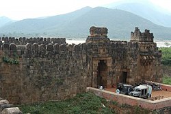
Siddavatam Fort
Siddavatam Fort was constructed by Matti Raja, a Tuluva dynasty feudatory chief to the Vijayanagara Empire, in 1303CE.[5] It lies on the banks of the Pennar River. The fort extends over an area of 30 acres (12ha). Visitors can view gateways and decorated pillars at the two ends of the fort. Top of the fort has been adorned with carvings of Gajalakshmi. It is noteworthy that the 17 bastions which once used to protect the region are still visible in the fort.[6]
The fort houses an ancillary passage which allows the visitors to gain access even after the closure of the main gates. It is considered as the gateway to Dakshina Kashi. The temples and masjid present inside its premise include the Ranganatha Swamy Temple.
Later Aurangzeb's commander Mir Jumla II in 1682 along with shah nawaz khan captured Siddavatam along with other places in the region. Later Aarkatu Nawabs occupied the town. In 1714 Abdul Nabi Khan, who was ruling Kadapa conquered Siddavatam. This place was also ruled by Mayana Nawabs for some period. In 1799, it went into the hands of British East India Company.[6]
From 1807 to 1812 Siddavatam was the district headquarters. However, since it is on the bank of river Penna, every time there was a flood, the place was marooned from other places of the district giving rise to administerial difficulties and subsequently the district headquarters was shifted to Kadapa.
Climate
Siddavatam has a tropical climate as is the encompassing region of Rayalaseema. The summers have temperatures ranging between 37°C and 45°C and normally occurs between the months of April and July.
During monsoons the climate starts to cool down and the river swells up during the rains which could sometimes be very hazardous especially during the torrential rains in the months of August to October.
The months between September and March are relatively cool, January being the coolest with a temperature averaging at 18°C.[7]
Siddavatam Fort, a key historical landmark in Andhra Pradesh tourism, draws visitors with its 700-year-old Hindu-Islamic architecture. Managed by the Archaeological Survey of India since 1956, it anchors Kadapa tourism. The area is renowned for temple tourism, featuring the Sri Ranganatha Swamy Temple, recently enhanced by a new Koneru inaugurated by MP Y.S. Avinash Reddy, and the Jyoti Siddavateswara Swamy and Panchalingala temples, showcasing cultural heritage. A 16-pillar Mantapam honors Bhaskara Pantulu, a local figure linked to the nearby Bhakarapeta hamlet (often misspelled as Bhakara Pantulu). Supported by CM Y.S. Jagan Mohan Reddy’s vision for regional development, ongoing efforts to improve access and facilities elevate Siddavatam’s appeal as a cultural destination.
References
↑ "Revenue Divisions and Mandals". Official website of YSR Kadapa District. National Informatics Centre- Kadapa, Andhra Pradesh. Retrieved 23 May 2015.
This page is based on this Wikipedia article Text is available under the CC BY-SA 4.0 license; additional terms may apply. Images, videos and audio are available under their respective licenses.