Related Research Articles
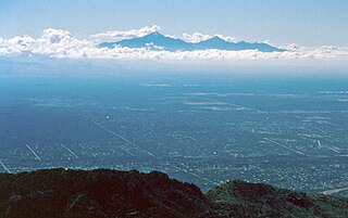
Sky islands are isolated mountains surrounded by radically different lowland environments. The term originally referred to those found near the southern borders of the U.S. states of Arizona and New Mexico with the northern borders of the Mexican States of Chihuahua and Sonora, and has extended to similarly isolated high-altitude forests. The isolation has significant implications for these natural habitats. The American Southwest region began warming up between ∼20,000–10,000 years BP and atmospheric temperatures increased substantially, resulting in the formation of vast deserts that isolated the sky islands. Endemism, altitudinal migration, and relict populations are some of the natural phenomena to be found on sky islands.
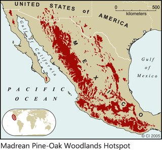
The Madrean pine–oak woodlands are an ecoregion of the tropical and subtropical coniferous forests and Temperate broadleaf and mixed forests biomes, located in North America. They are subtropical woodlands found in the mountains of Mexico and the southwestern United States.

The Madrean Sky Islands are enclaves of Madrean pine–oak woodlands, found at higher elevations in a complex of small mountain ranges in southern and southeastern Arizona, southwestern New Mexico, and northwestern Mexico. The sky islands are surrounded at lower elevations by the Sonoran and Chihuahuan deserts. The northern west–east perimeter of the sky island region merges into the higher elevation eastern Mogollon Rim and the White Mountains of eastern Arizona.

The Sierra Madre Occidental pine–oak forests are a Temperate broadleaf and mixed forests ecoregion of the Sierra Madre Occidental range from the southwest USA region to the western part of Mexico. They are home to a large number of endemic plants and important habitat for wildlife.

Crotalus willardi obscurus is a venomous pitviper subspecies found in northwestern Mexico and the Southwestern United States.This is the only venomous snake listed as Threatened by the U.S. Fish and Wildlife Service.

The Rio San Bernardino, or San Bernardino River, begins in extreme southeastern Cochise County, Arizona, and is a tributary of the Bavispe River, in Sonora, Mexico.
The Rio Bavispe or Bavispe River is a river in Mexico which flows briefly north then mainly south by southwest until it joins with the Aros River to become the Yaqui River, eventually joining the Gulf of California.

The Altar Valley is a 45-mile (72 km) long north-south valley, trending slightly northeast from Sasabe, Arizona on the Mexico border to the Avra Valley west of the Tucson Mountains. It is delimited by Arizona State Route 86, from east-to-west on the north separating it from the Avra Valley which then trends northwesterly, merging into the plains and drainage of the Santa Cruz River.

The Peloncillo Mountains of Hidalgo County,, is a major 35-mile (56 km) long mountain range southwest of New Mexico's Hidalgo County, and also part of the New Mexico Bootheel region. The range continues to the northwest into Arizona as the Peloncillo Mountains of Cochise County, Arizona. The extreme southwest corner of the range also lies in Arizona. It is a linear range bordering the linear San Bernardino Valley of southeast Cochise County, Arizona.
Sierra del Tigre is a mountain range in northeastern Sonora, Mexico at the northern region of the Sierra Madre Occidental. The region contains sky island mountain ranges, called the Madrean Sky Islands, some separated from the Sierra Madre Occidental proper, and occurring in the northeastern Sonoran Desert, and extreme west-northwestern Chihuahuan Desert. Many of the ranges occur in southeast Arizona.

The San Bernardino Valley of Arizona is a 35 mi (56 km) northeast-by-southwest trending valley in extreme southeast Cochise County, Arizona. The north end of the valley merges into the northwest-by-southeast trending San Simon Valley; both merge in western perimeter Hidaldgo County, New Mexico. The valley is an asymmetric graben.
The Sierra San Antonio is a mountain range in southernmost Arizona state (U.S.) and northern Sonora state (México).

Salix bonplandiana, , is a perennial species of willow tree native to southern and southwest Mexico and extending into central Guatemala; in western Mexico it is a tree of the Sierra Madre Occidental cordillera, but also occurring in other small locales, for example Baja California Sur, northern Sonora, San Luis Potosi, etc. A core disjunct area occurs in central and southeast Arizona, in advantageous locales, especially associated with higher elevations and water.
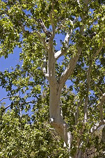
Platanus wrightii, the Arizona sycamore, is a sycamore tree native to Arizona and New Mexico with its range extending south into the Mexican states of Sonora, Chihuahua, and Sinaloa.
The Sierra La Esmeralda range, are a mountain range in northern Sonora, Mexico at the northern region of the Sierra Madre Occidental cordillera. The region contains sky island mountain ranges, called the Madrean Sky Islands, some separated from the Sierra Madre Occidental proper, and occurring in the northeastern Sonoran Desert, and extreme west-northwestern Chihuahuan Desert. Many of the ranges occur in southeast Arizona.

The Animas Valley is a lengthy and narrow, north-south 85 mi (137 km) long, valley located in western Hidalgo County, New Mexico in the Bootheel Region; the extreme south of the valley lies in Sonora-Chihuahua, in the extreme northwest of the Chihuahuan Desert, the large desert region of the north-central Mexican Plateau and the Rio Grande valley and river system.
Whitewater Draw, originally Rio de Agua Prieta, [Spanish: river of dark water], is a tributary stream of the Rio de Agua Prieta in Cochise County, Arizona. It was called Blackwater Creek by Philip St. George Cooke when his command, the Mormon Battalion, camped at a spring on its course on December 5, 1846.
References
- ↑ Geographic isolation,..a threatened sky island rattlesnake.
- ↑ Serrano, Karla Pelz; Guevara, Eduardo Ponce; Gonzalez, Carlos A. Lopez (2005). "Habitat and conservation status of the beaver in the Sierra San Luis Sonora, Mexico". In: Gottfried, Gerald J.; Gebow, Brooke S.; Eskew, Lane G.; Edminster, Carleton B., Comps. Connecting Mountain Islands and Desert Seas: Biodiversity and Management of the Madrean Archipelago Ii. Proc. RMRS-P-36. Fort Collins, Co: U.S. Department of Agriculture, Forest Service, Rocky Mountain Research Station: 429-433. 036.
Fauna and flora:
Rio Bavispe Reserve & Sierra del Tigre