
The Picos de Europa are a mountain range extending for about 20 km, forming part of the Cantabrian Mountains in northern Spain. The range is situated in the Autonomous Communities of Asturias, Cantabria and Castile and León. The highest peak is Torre de Cerredo, at an elevation of 2650 m.
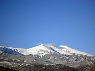
The Baetic System is one of the main systems of mountain ranges in Spain. Located in the southern and eastern Iberian Peninsula, it is also known as the Baetic Cordillera, Baetic Ranges or Baetic Mountains. The name of the mountain system derives from the ancient Roman region of Baetica, one of the Imperial Roman provinces of ancient Hispania.

The Sierra Morena is one of the main systems of mountain ranges in Spain. It stretches for 450 kilometres from east to west across the south of the Iberian Peninsula, forming the southern border of the Meseta Central plateau and providing the watershed between the valleys of the Guadiana to the north and the west, and the Guadalquivir to the south.

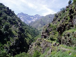
The Cantabrian Mountains or Cantabrian Range are one of the main systems of mountain ranges in Spain. They stretch for over 300 km (180 miles) across northern Spain, from the western limit of the Pyrenees to the Galician Massif in Galicia, along the coast of the Cantabrian Sea. Their easternmost end meets the Sistema Ibérico.

Riotuerto is one of the municipalities of Cantabria, lying between the North Coast of the Cantábrican Sea and the mountains of the Cantabrian Sierra. It is part of the ancient merindad (shire) of Trasmiera. The centre of Riotuerto is La Cavada, once the home of the famed Royal Artillery Factory and now the site of the Town Hall, library and cannon museum. Other barrios include Barrio de Arriba, Lombana, Monte and Angustina.

The Battle of Santander was fought over the summer of 1937 in the War in the North campaign in the Spanish Civil War. Santander's fall on August 26 assured the Nationalist conquest of the province of Santander, now Cantabria, and marked the last stand of the Republic's "Army of the North," which was destroyed and captured in the fighting.

The Chilean Coastal Range is a mountain range that runs from north to south along the Pacific coast of South America parallel to the Andean Mountains, extending from Morro de Arica in the north to Taitao Peninsula, where it ends at the Chile Triple Junction, in the south. The range has a strong influence on the climate of Chile since it produces a rain shadow to the east. Because of this the vegetation growing on the seaward slopes is much more exuberant than in the interior. Compared to the coastal lowlands and the Intermediate Depression it is sparsely populated with land use varying from protected areas to grazing and silviculture. The range is present in all Chilean regions except for Coquimbo Region and Magallanes Region.

Campoo is a comarca of Cantabria (Spain) located in the High Ebro, with a surface little bigger than 1,000 km2, and including the municipalities of Hermandad de Campoo de Suso, Campoo de Enmedio, Campoo de Yuso, Valdeolea, Valdeprado del Río, Valderredible, Reinosa, Las Rozas de Valdearroyo, Santiurde de Reinosa, Pesquera, and San Miguel de Aguayo. Their inhabitants are called Campurrians . Its highest elevation is the Cuchillón peak, and the lowest is Pesquera, with the capital, Reinosa at 850 m.

Valles Pasiegos is an administrative comarca in Cantabria, Spain. It is formed by the valleys of the Pas and Miera rivers, each one being a natural comarca of its own.

The Valleys of the Saja and Nansa Rivers comprise an administrative comarca in Cantabria, Spain. It is formed by the valleys of said rivers, each one being a natural comarca of its own.

The Puerto del Escudo is a mountain pass at 1,011 meters elevation located in the valley of Luena, to the east of the Sierra del Escudo mountain range and on the boundary between Cantabria and Castile in Spain. The source of the Magdalena or Luena River is located there. It has been one of the main access routes from the coast to the interior plateau crossing the Cantabrian Mountains. At the moment the N-623 highway runs over it and is well known for its steep inclines on its Cantabrian slope that can be up to 15%, causing a difficult transit for heavy vehicles. This characteristic and its altitude result in the relatively frequent closing of the pass when there is heavy snow in the winter.
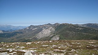
The Iberian System, is one of the major systems of mountain ranges in Spain. It consists of a vast and complex area of mostly relatively high and rugged mountain chains and massifs located in the central region of the Iberian Peninsula, but reaching almost the Mediterranean coast in the Valencian Country in the east.
Costa de Cantabria is a Spanish geographical indication for vino de la tierra wines located in the autonomous region of Cantabria, on the north coast of Spain. Vino de la tierra is one step below the mainstream denominación de origen indication on the Spanish wine quality ladder.

El Soplao is a cave located in the municipalities of Rionansa, Valdáliga and Herrerías in Cantabria, Spain. It is considered unique for the quality and quantity of geological formations (speleothems) in its 17 miles length, 6 of which are open to the public. In it are formations such as helíctites and curtains. Its formation dates back to the Mesozoic, in particular the Cretaceous period 240 million years ago. The entrance is at 540 metres in the Sierra Soplao Arnero.

Serra d'Espadà is a 51 km (32 mi) long mountain range in the Alt Palància, Alt Millars and Plana Baixa comarcas, in the Province of Castellón, Valencian Community, Spain. Its highest point is La Ràpita.

Serra Calderona, often referred to as La Calderona is a 49 km (30 mi) long mountain range in the Camp de Túria, Horta Nord and Alt Palància comarcas of the Valencian Community, between the provinces of Castelló and Valencia Spain.
Sierra Norte de Sevilla or Sierra Norte is one of the western mountain ranges of the Sierra Morena, Andalusia, Spain. Its name derives from its location at the northern part of Sevilla Province. The highest point of the range is the 960 m high Cerro de La Capitana.
Val de San Vicente is a municipality located in the autonomous community of Cantabria, Spain.
The Sierra de Híjar is a mountain range of the Cantabrian Mountains System, located in the Province of Palencia and the Autonomous Community of Cantabria in northern Spain.


