
Mont Blanc is the highest mountain in the Alps and Western Europe, and the highest mountain in Europe outside the Caucasus mountains, rising 4,805.59 m (15,766 ft) above sea level, located on the French-Italian border. It is the second-most prominent mountain in Europe, after Mount Elbrus, and the 11th most prominent mountain summit in the world.

Lozère is a landlocked department in the region of Occitanie in Southern France, located near the Massif Central, bounded to the northeast by Haute-Loire, to the east by Ardèche, to the south by Gard, to the west by Aveyron, and the northwest by Cantal. It is named after Mont Lozère. With 76,604 inhabitants as of 2019, Lozère is the least populous French department.
The Massif Central is a highland region in south-central France, consisting of mountains and plateaus. It covers about 15% of mainland France.

The following is a list of the 152 communes of the Lozère department of France.

Monte Rosa is a mountain massif in the eastern part of the Pennine Alps, on the border between Italy and Switzerland (Valais). The highest peak of the massif, amongst several peaks of over 4.000 m, is the Dufourspitze, the second highest mountain in the Alps and western Europe, after Mont Blanc. The east face of the Monte Rosa towards Italy has a height of about 2.400 meters and is the highest mountain wall of the Alps.

The arrondissement of Mende is an arrondissement of France in the Lozère department in the Occitanie région. Its INSEE code is 482 and its capital city, and prefecture of the department, is Mende. Its population is 63,180 (2016), and its area is 3,479.4 km2 (1,343.4 sq mi).
Saint-Denis-en-Margeride is a commune in the Lozère department in southern France.

Gaspésie National Park is a provincial park located south of the town of Sainte-Anne-des-Monts, Quebec, Canada in the inland of the Gaspé peninsula. The park contains the highest peak of the Appalachian Mountains in Canada, Mont Jacques-Cartier, 1,270 metres (4,170 ft) above sea level. In addition, the park contains the only population of Caribou found south of the Saint Lawrence River in Canada.

Margeride is a mountainous region of France, situated in the Massif Central, inside the départements of Cantal, Haute-Loire and Lozère.

Margerides is a commune in the Corrèze department in central France.
Basse-sur-le-Rupt is a commune in the Vosges department in Grand Est in northeastern France. Its inhabitants are called Bassurois. It is a mountainous commune of seven hamlets, crossed by the river Rupt. Its landmarks include Le Haut du Roc, Le Pierre des Communes, Le Piquante Pierre and the memorial of Le Croix des Moinats. Its historical industries were textiles, sawmills and granite.

Matour is a commune in the department of Saône-et-Loire in Bourgogne-Franche-Comté, France. Its territory is classified Natura 2000. The commune is located in a zone de revitalisation rurale.

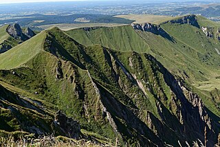
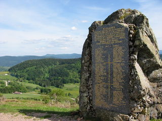
Mont Mouchet is a 1,497-metre-high (4,911 ft) mountain located on the border of the French départements of Cantal, Haute-Loire and Lozère. It is famous for the historical events which took place there, notably during the Second World War where it hosted a group of French resistance fighters, the Maquis du Mont Mouchet. At the summit there is a large cairn and view-point from which there is a splendid panoramic view over much of Central France from the Massif Central to the Alps.

The Chapeauroux is a 56.1-kilometre (34.9 mi) long river in the Lozère and Haute-Loire départements, south-central France. Its source is near Estables, in the Margeride. It flows generally northeast. It is a left tributary of the Allier into which it flows between Saint-Bonnet-de-Montauroux and Saint-Christophe-d'Allier.
The Albera Massif is a mountain range located in the south of Pyrénées-Orientales and the north of Catalonia, between France and Spain. It is the main easternmost prolongation of the Pyrenees. Its highest peak is the Puig Neulós, with an elevation of 1,256 metres.
The canton of Saint-Alban-sur-Limagnole is an administrative division of the Lozère department, southern France. Its borders were modified at the French canton reorganisation which came into effect in March 2015. Its seat is in Saint-Alban-sur-Limagnole.

The Truc de Fortunio is a summit of the Margeride, a natural region located mainly in Lozère, but also in Cantal and Haute-Loire. It is situated in the Lozère department, in the commune of Rieutort-de-Randon, near the Truc de Randon and the Signal de Randon.

The Moure de la Gardille is a summit of the Massif Central belonging to the Margeride mountains in Lozère. It is located near Mont Lozère.
Puech David is a summit in the Massif Central belonging to the Margeride mountains.

