
The Silva Ciminia, the Ciminian Forest, was the unbroken primeval forest that separated Ancient Rome from Etruria. According to the Roman historian Livy it was, in the 4th century BCE, a feared, pathless wilderness [1] in which few dared tread. [2]
The Silva Ciminia, the Ciminian Forest, was the unbroken primeval forest that separated Ancient Rome from Etruria. According to the Roman historian Livy it was, in the 4th century BCE, a feared, pathless wilderness [1] in which few dared tread. [2]
The Ciminian Forest received its name from the Monti Cimini, which are still a densely wooded range of volcanic hills northwest of Rome. They form the part of the forerange of the Apennine main range that faces towards the Tyrrhenian Sea.
In the south, the Silva Ciminia stretched from Lake Bracciano to the edges of the flat plain of the Roman Campagna, in the lower Tiber Valley. Stretches of cleared fields round the major Etruscan settlements formed the Ager Veientanus that supported Veii, the Ager Faliscus of the Falisci, and the Ager Capenas of Capena. In the heart of the Ciminian woodlands lay the Ciminus Lake (Lago di Vico). In the northwest, they reached as far as Tarquinia. [3]
The forest was predominantly formed by oak and beech, though second growth in the lower slopes has favoured the aggressively re-seeding Spanish chestnut. [4] A relict stand of beech, rare in Central Italy, remains on the upper slopes of Monte Cimino. Sub-fossil pollen analyses [5] from cores of stratified sediment taken in the region's crater lakes typically reveal a pollen sequence [6] characteristic of tundra lying over an all-but-sterile wind-blown loess sand; this in turn was followed by grassland, with pollen of water-lilies and pondweeds blown from glacial meltwater lakes. The earliest Holocene forest was fir, followed by mixed pine and oak, with a climax forest of beech and oak, including Quercus ilex .
The surface profiles have been transformed since the region was first deforested in Roman times, as settlers worked outwards from strips flanking the Roman roads — the via Cassia, the via Amerina and the via Flaminia — which had been struck through the forest. In the deforested slopes, streams with even moderate flow have cut deeply eroded gullies and valleys in the geologically very recent soft tuff and volcanic ash. A sudden increase in organic sediments in strata corresponding to the third century BCE records this erosion following agrarian deforestation, which, far downstream, would initiate the Tiber's delta. Thereafter the palynological record attests many cultivated plants, and, significantly, nettles, the weed of disturbed, untended corners that follows temperate agriculture everywhere. By the third and fourth centuries CE very little of the primeval forest survived. [7]
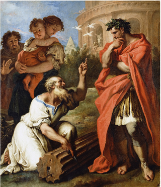
To the Romans of the Republic, the forest was as much feared as the trackless Hercynian Forest would be when they encountered that. In 310 BCE the Roman Senate, even after the rout of the Etruscans at Sutrium, charged the consul Fabius Maximus Rullianus not to enter this woodland in pursuit of the Etruscans, and when it emerged that he had done so, all Rome was struck with terror. [8] The Silva formed a natural barrier between Ancient Rome and Etruria. [9]
| Authority control databases: Geographic |
|---|
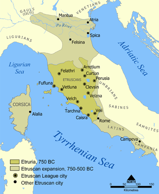
The Etruscan civilization was an ancient civilization created by the Etruscans, a people who inhabited Etruria in ancient Italy, with a common language and culture who formed a federation of city-states. After conquering adjacent lands, its territory covered, at its greatest extent, roughly what is now Tuscany, western Umbria, and northern Lazio, as well as what are now the Po Valley, Emilia-Romagna, south-eastern Lombardy, southern Veneto, and western Campania.

Veii was an important ancient Etruscan city situated on the southern limits of Etruria and 16 km (9.9 mi) north-northwest of Rome, Italy. It now lies in Isola Farnese, in the comune of Rome. Many other sites associated with and in the city-state of Veii are in Formello, immediately to the north. Formello is named after the drainage channels that were first created by the Veians.
Etruria was a region of Central Italy delimited by the rivers Arno and Tiber, an area that covered what is now most of Tuscany, northern Lazio, and north-western Umbria. It was inhabited by the Etruscans, an ancient civilization that flourished in the area from around the 8th century BC until they were assimilated into the Roman Republic in the 4th century BC.

Falerii is a village in the municipality of Fabrica di Roma in the Province of Viterbo, Italy. Its name is better known for two nearby ancient cities, Falerii Veteres and Falerii Novi.

The Falisci were an Italic tribe who lived in what is now northern Lazio, on the Etruscan side of the Tiber River. They spoke an Italic language, Faliscan, closely related to Latin. Originally a sovereign state, politically and socially they supported the Etruscans, joining the Etruscan League. This conviction and affiliation led to their ultimate near destruction and total subjugation by Rome.
The First, Second, and Third Samnite Wars were fought between the Roman Republic and the Samnites, who lived on a stretch of the Apennine Mountains south of Rome and north of the Lucanian tribe.
In Etruscan and Sabine religion, Feronia was a goddess associated with wildlife, fertility, health, and abundance, also venerated by the Faliscans and later adopted into ancient Roman religion. As the goddess who granted freedom to slaves or civil rights to the most humble part of society, she was especially honored among plebeians and freedmen. Her festival, the Feroniae, was November 13 during the Ludi Plebeii, in conjunction with Fortuna Primigenia; both were goddesses of Praeneste.
Volsinii or Vulsinii, is the name of two ancient cities of Etruria, one situated on the shore of Lacus Volsiniensis, and the other on the Via Clodia, between Clusium (Chiusi) and Forum Cassii (Vetralla). The latter was Etruscan and was destroyed by the Romans in 264 BC following an attempted revolt by its slaves, while the former was founded by the Romans using the remainder of the Etruscan population rescued from the razed city.
Clusium was an ancient city in Italy, one of several found at the same site overlapping the current municipality of Chiusi (Tuscany). The Roman city remodeled an earlier Etruscan city, Clevsin, found in the territory of a prehistoric culture, possibly also Etruscan or proto-Etruscan. The site is located in northern central Italy on the west side of the Apennines.
The gens Tarquinia was a plebeian family at ancient Rome, usually associated with Lucius Tarquinius Priscus and Lucius Tarquinius Superbus, the fifth and seventh Kings of Rome. Most of the Tarquinii who appear in history are connected in some way with this dynasty, but a few appear during the later Republic, and others from inscriptions, some dating as late as the fourth century AD.

Feronia or Lucus Feroniae was an ancient Roman municipium border the present Via Tiberina and Autostrada A1, current Comune of Capena near the present town of Fiano Romano. It is located in the plain along the Tiber Valley, at the foot of Mount Soracte, and was within the ancient territory of Capena. It began as a sanctuary called Lucus Feroniae in the time of Tullus Hostilius when it was located in Etruria.

Latium is the region of central western Italy in which the city of Rome was founded and grew to be the capital city of the Roman Empire.

Eretum, was an ancient town of the Sabines, situated on the Via Salaria, at its junction with the Via Nomentana, a short distance from the Tiber, and about 30 km (19 mi) from Rome.
Etruscan cities were a group of ancient settlements that shared a common Etruscan language and culture, even though they were independent city-states. They flourished over a large part of the northern half of Italy starting from the Iron Age, and in some cases reached a substantial level of wealth and power. They were eventually assimilated first by Italics in the south, then by Celts in the north and finally in Etruria itself by the growing Roman Republic.
The Silva Arsia is a forest or wooded area near Rome situated where the Roman and Veientine territories abutted. Legend has it that in 509 BCE Romans heard the prophetic voice of Silvanus foretelling their victory over the Etruscans (Livy), 2.7.2). At the Battle of Silva Arsia that year the forces said to have been assembled by the Etruscan Tarquin were defeated, though with the loss of the Roman consul Lucius Junius Brutus. The forest, rich in timber essential for shipbuilding, had been seized from the Etruscans of Veii by Ancus Martius.
The Battle of Silva Arsia was a battle in 509 BC between the republican forces of ancient Rome and Etruscan forces of Tarquinii and Veii led by the deposed Roman king Lucius Tarquinius Superbus. It resulted in victory to the nascent Roman Republic.
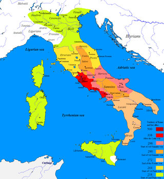
The Roman–Etruscan Wars, also known as the Etruscan Wars or the Etruscan–Roman Wars, were a series of wars fought between ancient Rome and the Etruscans. Information about many of the wars is limited, particularly those in the early parts of Rome's history, and in large part is known from ancient texts alone. The conquest of Etruria was completed in 265–264 BC.

Titus Herminius, surnamed Aquilinus, was one of the heroes of the Roman Republic. He participated in two of the most famous conflicts that attended the birth of the Republic, and was elected consul in 506 BC. However, his greatest fame was won as one of the defenders of the Sublician bridge against the army of Lars Porsena, the King of Clusium.

Lake of the Idols is a lake located in Arezzo Province, Tuscany, Italy. It is located 1,380 metres (4,530 ft) above sea level atop Monte Falterona, about 600 metres from the source of the river Arno. Situated near an ancient road linking Etruria with the Adriatic port cities of Romagna, it is known for one of the largest archaeological finds of the Etruscan civilization; over 600 bronze statuettes of Etruscan and Roman origin, along with thousands of other figurines from Cisalpine Gaul and Umbria, were discovered within the lake.

Mount Cimino is the highest peak in Lazio's Anti-Apennine chain of the Cimini Mountains, and in the entire province of Viterbo. It towers above the town of Soriano nel Cimino.