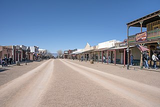
Tombstone is a historic city in Cochise County, Arizona, United States, founded in 1879 by prospector Ed Schieffelin in what was then Pima County, Arizona Territory. It became one of the last boomtowns in the American frontier. The town grew significantly into the mid-1880s as the local mines produced $40 to $85 million in silver bullion, the largest productive silver district in Arizona. Its population grew from 100 to around 14,000 in less than seven years. It is best known as the site of the Gunfight at the O.K. Corral and presently draws most of its revenue from tourism. It also houses the highest-rated brewery in the state of Arizona.

Top-of-the-World is a census-designated place (CDP) in Gila and Pinal counties in the U.S. state of Arizona. The population was 231 at the 2010 census, down from 330 at the 2000 census.
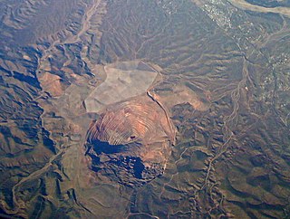
Superior is a town in Pinal County, Arizona. According to the 2020 census, the population of the town is 2,407. Superior was founded as a mining town for the Silver King and the later Magma mines; silver was mined at first, and then transitioned to copper. Currently, exploitation of the huge Resolution Copper deposit is being explored.

The Chino Mine, also known as the Santa Rita mine, also known as Santa Rita del Cobre, is an open-pit porphyry copper mine located in the town of Santa Rita, New Mexico 15 miles (24 km) east of Silver City. The mine was started as the Chino Copper Company in 1909 by mining engineer John M. Sully and Spencer Penrose, and is currently owned and operated by Freeport-McMoRan Inc. subsidiaries. The area where the mine is located is at an average elevation of 5,699 feet (1,737 m).

Hillsboro is an unincorporated community in Sierra County, New Mexico, United States, located in the southwestern part of the state. It was founded in 1877, following the discovery of gold. The community was the county seat of Sierra County from 1884 until 1936, when Hot Springs became the county seat.

Porphyry copper deposits are copper ore bodies that are formed from hydrothermal fluids that originate from a voluminous magma chamber several kilometers below the deposit itself. Predating or associated with those fluids are vertical dikes of porphyritic intrusive rocks from which this deposit type derives its name. In later stages, circulating meteoric fluids may interact with the magmatic fluids. Successive envelopes of hydrothermal alteration typically enclose a core of disseminated ore minerals in often stockwork-forming hairline fractures and veins. Because of their large volume, porphyry orebodies can be economic from copper concentrations as low as 0.15% copper and can have economic amounts of by-products such as molybdenum, silver, and gold. In some mines, those metals are the main product.

Tiger is a former populated place in Pinal County in the U.S. state of Arizona. The town was settled as Schultzcirca 1881 in what was then the Arizona Territory, then later reestablished as Tiger after World War I.
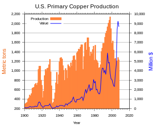
Copper mining in the United States has been a major industry since the rise of the northern Michigan copper district in the 1840s. In 2017, the United States produced 1.27 million metric tonnes of copper, worth $8 billion, making it the world's fourth largest copper producer, after Chile, China, and Peru. Copper was produced from 23 mines in the US. Top copper producing states in 2014 were Arizona, Utah, New Mexico, Nevada, and Montana. Minor production also came from Idaho, and Missouri. As of 2014, the US had 45 million tonnes of known remaining reserves of copper, the fifth largest known copper reserves in the world, after Chile, Australia, Peru, and Mexico.
Silver mining in Arizona was a powerful stimulus for exploration and prospecting in early Arizona. Cumulative silver production through 1981 totaled 490 million troy ounces. However, only about 10% of Arizona's silver production came from silver mining. More than 80% of the state's silver was a byproduct of copper mining; other silver came as a byproduct of lead, zinc, and gold mining.
Pinal or Pinal City is a ghost town in Pinal County in the U.S. state of Arizona. The town was populated from the 1870s into the 1890s, in what was then the Arizona Territory.
The Castle Dome Mountains are a mountain range in Yuma County, Arizona, within the Kofa National Wildlife Refuge. Castle Dome Peak, the high point of the range, is a prominent butte and distinctive landmark. The peak is 3,776 feet (1,151 m) high, and is located at 33°05′04″N114°08′36″W. Castle Dome was named by American soldiers at old Fort Yuma in the 1880s. Early Spanish explorers called the same peak Cabeza de Gigante, "Giant's Head."

Helvetia is a ghost town in Pima County, Arizona, United States that was settled in 1891 and abandoned in the early 1920s. Helvetia is an ancient name for Switzerland.

Harshaw is a ghost town in Santa Cruz County in the southeastern part of the U.S. state of Arizona. The town was settled in the 1870s, in what was then Arizona Territory. Founded as a mining community, Harshaw is named after the cattleman-turned-prospector David Tecumseh Harshaw, who first successfully located silver in the area. At the town's peak near the end of the 19th century, Harshaw's mines were among Arizona's highest producers of ore, with the largest mine, the Hermosa, yielding approximately $365,455 in bullion over a four-month period in 1880.
The San Manuel Copper Mine was a surface and underground porphyry copper mine located in San Manuel, Pinal County, Arizona. Frank Schultz was the original discoverer, in 1879, but the main body of the deposits were discovered by Henry W. Nichols in 1942. The exploration drilling went on from 1943 to 1948, with the first mine shaft built 1948. Louis Lesser developed a mining city to service Nichols’ newly discovered deposits, and the development was completed about 1954. The first major production began in 1955. The mine and smelter were permanently closed in 2003.
McMillenville, also known as McMillianville or McMillanville, is a populated place in Gila County, Arizona. Silver ore was discovered by chance in 1876 by Theodore H. Harris and Charles McMillen, and the town formed around the ore deposits.

Kingston is a census-designated place (CDP) in Sierra County, New Mexico, United States. Its population was 32 as of the 2010 census. The community is located in the Black Range along New Mexico State Road 152.

The Pinal Mountains are a mountain range located in Gila County, Arizona. They have a maximum elevation of 7,848 ft (2,392 m) at Pinal Peak and a prominence of over 4,000 ft (1,200 m). The closest city is the Globe, Arizona/Miami, Arizona area, which is just a few miles north of the mountain range. The mountains are located within the Tonto National Forest, and their recreational facilities are maintained by the USDA's United States Forest Service. The San Carlos Indian Reservation is very close to the mountain range, with its boundaries being just a few miles east/northeast of the range. The mountains are covered with Ponderosa Pine and white fir and experience cooler weather than the Globe/Miami area, so that they are a popular recreation area in the summer. The maintained facilities include a maintained dirt road that goes all the way to the summit of Pinal Peak, a campsite and recreational area, many hiking trails, as well as some radio towers near both Pinal and Signal peaks. The mountain range covers an area of 45,760 acres.

The Historic Pinal Cemetery, first known simply as "Pinal Cemetery", is a cemetery located on a hill in what once within the jurisdiction of the now ghost town of Pinal City. The Pioneers' Cemetery Association (PCA) defines a "historic cemetery" as one which has been in existence for more than fifty years. In 2009, the Tonto National Forest made it its goal to develop and manage the cemetery as an interpretive site while preserving its historic context and integrity as an archaeological resource. Among those who are buried in the cemetery is Celia Ann “Mattie” Blaylock Earp who was Wyatt Earp's common law wife. The role of Mattie Earp was played by actress Dana Wheeler-Nicholson in the 1993 American Western film Tombstone.

