Oak Park is an unincorporated community in Ventura County, California, United States. When developed in the Simi Hills in the late 1960s, a single road provided the only access to the community from Agoura Hills, California, in neighboring Los Angeles County. As of the 2010 census, Oak Park had a population of 14,266, down from 14,625 at the 2000 census. For statistical purposes, the United States Census Bureau has defined Oak Park as a census-designated place (CDP). The census definition of the area may not precisely correspond to local understanding of the area with the same name.

The Santa Monica Mountains is a coastal mountain range in Southern California, next to the Pacific Ocean. It is part of the Transverse Ranges. Because of its proximity to densely populated regions, it is one of the most visited natural areas in California. Santa Monica Mountains National Recreation Area is located in this mountain range.
The Santa Monica Mountains Conservancy is an agency of the state of California in the United States founded in 1980 and dedicated to the acquisition of land for preservation as open space, for wildlife and California native plants habitat Nature Preserves, and for public recreation activities.

The Santa Susana Mountains are a transverse range of mountains in Southern California, north of the city of Los Angeles, in the United States. The range runs east-west, separating the San Fernando Valley and Simi Valley on its south from the Santa Clara River Valley to the north and the Santa Clarita Valley to the northeast. The Oxnard Plain is to the west of the Santa Susana Mountains.

West Hills is a residential and commercial neighborhood in the western San Fernando Valley region of the City of Los Angeles, California. The percentage of residents aged 35 and older is among the highest in Los Angeles County.
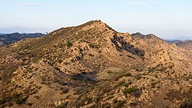
El Escorpión Park is a three-acre park located in the Simi Hills of the western San Fernando Valley, in the West Hills district of Los Angeles, California. The park contains the geographic landmark known as Escorpión Peak or Castle Peak, a 1,475-foot-tall rocky peak seen from most parts of the park and the surrounding community.

Rocky Peak, located in Rocky Peak Park, is the fourth-highest point in the Santa Susana Mountains, and overlooks the San Fernando Valley and Chatsworth, the Simi Hills, and the Simi Valley in Southern California. The peak, which is 2,715 feet (828 m) in elevation, sits on the Los Angeles County–Ventura County line.

The Simi Hills are a low rocky mountain range of the Transverse Ranges in eastern Ventura County and western Los Angeles County, of southern California, United States.

The Upper Las Virgenes Canyon Open Space Preserve is a large open space nature preserve owned and operated by the Santa Monica Mountains Conservancy spanning nearly 3,000 acres (1,200 ha) in the Simi Hills of western Los Angeles County and eastern Ventura County.

The Santa Monica Mountains National Recreation Area is a United States national recreation area containing many individual parks and open space preserves, located primarily in the Santa Monica Mountains of Southern California. The SMMNRA is in the greater Los Angeles region, with two thirds of the parklands in northwest Los Angeles County, and the remaining third, including a Simi Hills extension, in southeastern Ventura County.

Bell Canyon is an unincorporated community in eastern Ventura County, California, United States. Bell Canyon is a gated community in the Simi Hills with the main access through the Los Angeles community of West Hills and the western San Fernando Valley. Bell Canyon sits at an elevation of 1,368 feet (417 m). The 2010 United States census reported Bell Canyon's population was 2,049. For statistical purposes, the United States Census Bureau has defined Bell Canyon as a census-designated place (CDP). The census definition of the area may not precisely correspond to local understanding of the area with the same name. According to a 2016 study, Bell Canyon is the seventh wealthiest community in the state of California with an annual median income of $230,000. However, incomes in this area are commonly upwards of millions of dollars a year.

Old Agoura, also referred to simply as "Agoura" by some locals, is a district on the east side of the city of Agoura Hills, located in the Simi Hills of western Los Angeles County, California.
Bell Canyon Park is a large open-space regional park located in the Simi Hills at the western end of the San Fernando Valley in West Hills, Los Angeles and Bell Canyon, California. Bell Creek, a primary tributary to the Los Angeles River, flows through the park with riparian zone vegetation along its natural banks. The geographic landmark Escorpión Peak is high above it to the south in adjacent El Escorpión Park.

The city of Simi Valley, in the valley of the same name, is in the southeast corner of Ventura County, California, United States, 40 miles (65 km) from downtown Los Angeles, making it part of the Greater Los Angeles Area. The city sits next to Thousand Oaks, Moorpark, and Chatsworth. The city's 2019 population has been estimated at 125,613, up from 124,243 in 2010. The city of Simi Valley is surrounded by the Santa Susana Mountain range and the Simi Hills, west of the San Fernando Valley, and northeast of the Conejo Valley. It grew as a commuter bedroom community for the cities in the Los Angeles area and the San Fernando Valley when a freeway was built over the Santa Susana Pass.
China Flat is a plateau in the north−central Simi Hills, in Ventura County, Southern California.
Bridle Path is a community in the southwestern area of the City of Simi Valley, in Ventura County, Southern California.

Rancho Conejo Playfields is a 13 acres (5.3 ha) multi-use community park in Newbury Park, California, adjacent to Conejo Canyons Open Space and the Arroyo Conejo Nature Preserve which includes 302 acres (122 ha) of public open-space land and numerous trails in the western Simi Hills.

Hill Canyon is a deep canyon in the western Simi Hills and within northern Newbury Park and Thousand Oaks, in Ventura County, southern California.

Ventu Park Open Space is a 141-acre open space area in Newbury Park, California. Its primary features are the Rosewood Trail leading to Angel Vista, a 1,603 ft peak in the Santa Monica Mountains. Parking for the Rosewood Trail is located at the Stagecoach Inn Park, across Lynn Road from the primary trailhead. The Rosewood Trail begins with oak woodland and crosses a creek at the canyon floor, before climbing up towards the steep Angel Vista Point. There are 360-degree panoramic views of the Conejo Valley, the Oxnard Plain, the California Channel Islands, Pacific Ocean, Point Mugu, Hidden Valley, as well as the Santa Monica-, Santa Susana- and Topa Topa Mountains.

Tarantula Hill, also known as Dawn’s Peak, is a 1,057-foot-high (322 m) peak in Thousand Oaks, California. It is located on a 45-acre (18 ha) open space and is operated by the Conejo Open Space Conservation Agency (COSCA). Climbing Tarantula Hill is a steep 0.5-mile (0.80 km) trail; the trailhead is located at 287 West Gainsborough Road, across the road from the main entrance to Conejo Valley Botanic Garden. Atop the mountain there is a 360-degree panoramic view of the Conejo Valley, the Simi Hills and the Santa Monica Mountains. There is also a fenced-in water reservoir located on top. It was once a popular hang-gliding site. It was once a volcanic mound but went dormant 16 million years ago.