
Üsküdar is a large and densely populated district of Istanbul, Turkey, on the Anatolian shore of the Bosphorus. It is bordered to the north by Beykoz, to the east by Ümraniye, to the southeast by Ataşehir and to the south by Kadıköy; with Karaköy, Kabataş, Beşiktaş, and the historic city center of Fatih facing it on the opposite shore to the west. Üsküdar has been a conservative cultural center of the Anatolian/Asian side of Istanbul since Ottoman times with its numerous grand and little historic mosques and dergahs. It is home to about half a million people.

Diyarbakır is the largest Kurdish-majority city in Turkey. It is the administrative center of Diyarbakır Province.

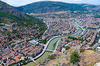
Kars is a city in northeast Turkey and the capital of Kars Province. Its population is 73,836 in 2011. Kars was in the ancient region known as Chorzene, in classical historiography (Strabo), part of Kingdom of Armenia (antiquity), in Ayrarat province, and later the capital of Bagratid Kingdom of Armenia in 929–961. Currently, the mayor of Kars is Türker Öksüz. The city had an Armenian ethnic majority until it was conquered by Turkish nationalist forces in late 1920.
Amasya is a city in northern Turkey and is the capital of Amasya Province, in the Black Sea Region. It was called Amaseia or Amasia in antiquity. Amasya stands in the mountains above the Black Sea coast, set apart from the rest of Anatolia in a narrow valley along the banks of the Yeşilırmak River. Although near the Black Sea, this area is high above the coast and has an inland climate, well-suited to growing apples, for which Amasya province, one of the provinces in north-central Anatolia Turkey, is famed. It was the home of the geographer Strabo and the birthplace of the 15th century Armenian scholar and physician Amirdovlat Amasiatsi. Located in a narrow cleft of the Yeşilırmak (Iris) river, it has a history of 7,500 years with many traces still evident today.

Çorlu is a northwestern Turkish city in inland Eastern Thrace that falls under the administration of the Province of Tekirdağ. It is a rapidly growing industrial centre built on flatland located on the motorway Otoyol 3 and off the highway D.100 between Istanbul and Turkey's border with Greece and Bulgaria.

Aydın is a city in and the seat of Aydın Province in Turkey's Aegean Region. The city is located at the heart of the lower valley of Büyük Menderes River at a commanding position for the region extending from the uplands of the valley down to the seacoast. Its population was 207,554 in 2014. Aydın city is located along a region which was famous for its fertility and productivity since ancient times. Figs remain the province's best-known crop, although other agricultural products are also grown intensively and the city has some light industry.

Merzifon is a town and district in Amasya Province in the central Black Sea region of Turkey. It covers an area of 970 square kilometres (370 sq mi), and the population (2020) is 73,849 of which 57,900 live in the town of Merzifon, the remainder spread throughout the surrounding countryside. The mayor is Alp Kargı (CHP).

Nevşehir is a city and the capital district of Nevşehir Province in the Central Anatolia Region of Turkey. According to the 2020 census, the population of the city is 82,110. It is 290 km (180 mi) from the capital Ankara and lies within the historical region of Cappadocia.

Muş is a city and the provincial capital of Muş Province in Turkey. Its population is mostly Kurds.

Çeşme is a coastal town and the administrative centre of the district of the same name in Turkey's westernmost end, on a promontory on the tip of the peninsula that also carries the same name and that extends inland to form a whole with the wider Urla-Karaburun-Çeşme Peninsula. It is a popular holiday resort and the district center, where two thirds of the district population is concentrated. Çeşme is located 85 km west of İzmir, the largest metropolitan center in Turkey's Aegean Region. There is a six-lane highway connecting the two cities. Çeşme district has two neighboring districts, Karaburun to the north and Urla to the east, both of which are also part of İzmir Province. The name "Çeşme" means "fountain" and possibly draws reference from the many Ottoman fountains that are scattered across the city.
Başmakçı is a town of Afyonkarahisar Province in the Aegean region of Turkey, closer to Denizli than to the city of Afyon itself. It is the seat of Başmakçı District. Its population is 4,993 (2021). The mayor is Halil Özcan (CHP).

Doğubayazıt is a district of Ağrı Province of Turkey, and it is the easternmost district of Turkey, lying near the border with Iran. Its elevation is 1625m and its area is 2,383 km². Doğubayazıt's population in 2010 was 115,354 of which 69,447 live in the town of Doğubayazıt, the remainder in the surrounding countryside. Also known as Kurdava, the town was the capital of the self-declared Republic of Ararat, an independent Kurdish state centered in the Ağrı Province.

İspir is a town and district of Erzurum Province in the Eastern Anatolia region of Turkey, on the Çoruh River. They also appear as the Sasperi, the name Sper with a Georgian prefix of place Sa-, which evolved into the term Iberian. The mayor is Ahmet Coşkun (MHP). The district has a population of 30,260 while the town has a population of 11,789.
Yusufeli is a town and district of Artvin Province in the Black Sea region of Turkey. It is located on the bank of Çoruh River 104 km south-west of the city of Artvin, on the road to Erzurum.

Ardanuç is a town and district in Artvin Province in Turkey's Black Sea region of Turkey, 32 km east of Artvin. The name Ardanuç derives from Lazuri language and Armenian.

Anzavur Ahmed Anchok Pasha was an Ottoman soldier, gendarme officer, pasha, and militia leader of Circassian origin. He was declared a Pasha by the late Ottoman government.

Ahmet Tevfik Pasha, later Ahmet Tevfik Okday after the Turkish Surname Law of 1934, was an Ottoman statesman of Crimean Tatar origin. He was the last Grand vizier of the Ottoman Empire. He held the office three times, the first in 1909 under Sultan Abdul Hamid II, and from 1918 to 1919 and from 1920 to 1922 under Mehmed VI during the Allied occupation of Istanbul. In addition to his premiership, Ahmet Tevfik was also a diplomat, a member of the Ottoman Senate, and the Minister of Foreign Affairs.
Paşalimanı Island, formerly Halone, is a small island in the southern Sea of Marmara in Turkey. The island is the fourth biggest island of Turkey and administratively belongs to the Erdek town of Balikesir Province in northwestern Turkey. The island has five small villages and has 962 population in total. Paşalimanı Island is also part of the Marmara Archipelago along with three other islands Marmara, Avşa and Ekinlik.

Turkey, officially the Republic of Türkiye, is a transcontinental country located mainly on the Anatolian Peninsula in Western Asia, with a small portion on the Balkan Peninsula in Southeast Europe. It shares borders with the Black Sea to the north; Georgia to the northeast; Armenia, Azerbaijan, and Iran to the east; Iraq to the southeast; Syria and the Mediterranean Sea to the south; the Aegean Sea to the west; and Greece and Bulgaria to the northwest. Cyprus is located off the south coast. Turks form the vast majority of the nation's population and Kurds are the largest minority. Ankara is Turkey's capital, while Istanbul is its largest city and financial centre.

Faik Ali Ozansoy was a Turkish politician, poet, and educator. He was the younger brother of Süleyman Nazif, an eminent man of letters and prominent member of the Committee for Union and Progress. Faik Ali was one of the foremost poets and writers of the Servet-i Fünun and Fecr-i Âti literary period. During World War I, Ozansoy served as the governor of Kütahya. Ozansoy is especially known for having saved the lives of thousands of Armenians during the Armenian genocide. Due to protecting the life of Armenian Christians, Ozansoy was known as the "governor of the infidels" by his contemporaries. On 24 April 2013, the day of remembrance for the Armenian Genocide, various prominent figures of both the Armenian and Turkish community visited his grave to pay tribute.
