
U.S. Route 66 or U.S. Highway 66 is one of the original highways in the United States Numbered Highway System. It was established on November 11, 1926, with road signs erected the following year. The highway, which became one of the most famous roadways in the United States, ran from Chicago, Illinois, through Missouri, Kansas, Oklahoma, Texas, New Mexico, and Arizona before terminating in Santa Monica in Los Angeles County, California, covering a total of 2,448 miles (3,940 km).

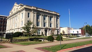
Tulsa County is a county located in the U.S. state of Oklahoma. As of the 2020 census, the population was 669,279, making it the second-most populous county in the state, behind only Oklahoma County. Its county seat and largest city is Tulsa, the second-largest city in the state. Founded at statehood, in 1907, it was named after the previously established city of Tulsa. Before statehood, the area was part of both the Creek Nation and the Cooweescoowee District of Cherokee Nation in Indian Territory. Tulsa County is included in the Tulsa metropolitan statistical area. Tulsa County is notable for being the most densely populated county in the state. Tulsa County also ranks as having the highest income.

Bristow is a city in Creek County, Oklahoma, United States. The population as of the 2020 Census was 4,248, up slightly from the population of 4,222 reported at the 2010 census.
Sapulpa is a city in Creek and Tulsa counties in the U.S. state of Oklahoma. The population was 21,929 at the time of the 2020 census, compared with 20,544 at the 2010 census. It is the county seat of Creek County.

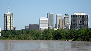
Tulsa is the second-most-populous city in the state of Oklahoma, after Oklahoma City, and the 48th-most-populous city in the United States. The population was 413,066 as of the 2020 census. It is the principal municipality of the Tulsa metropolitan area, a region with 1,034,123 residents. The city serves as the county seat of Tulsa County, the most densely populated county in Oklahoma, with urban development extending into Osage, Rogers and Wagoner counties.

Cyrus Stevens Avery (1871–1963) was a businessperson, oilman, and highway commissioner. He created the U.S. Route 66 while being a member of the federal board appointed to create the Federal Highway System, then pushed for the establishment of the U.S. Highway 66 Association to pave and promote the highway. As such, he is known as the "Father of Route 66".
The historic U.S. Route 66, sometimes known as the Will Rogers Highway after Oklahoma native Will Rogers, ran from west to northeast across the state of Oklahoma, along the path now taken by Interstate 40 (I-40) and State Highway 66 (SH-66). It passed through Oklahoma City, Tulsa, and many smaller communities. West of the Oklahoma City area, it has been largely replaced by I-40; the few independent portions that are still state-maintained are now I-40 Business. However, from Oklahoma City northeast to Kansas, the bypassing I-44 is mostly a toll road, and SH-66 remains as a free alternate.
Tulsa is the second-largest city in the state of Oklahoma. It has many diverse neighborhoods due to its size.

Oklahoma City Union Depot is a building in Oklahoma City, Oklahoma that served as a "union station" from 1931 until 1967. It was listed on the National Register of Historic Places in 1979. It now houses the offices of the Scissortail Park Foundation.

The 11th Street Bridge was completed in December 1915 to carry vehicles across the Arkansas River at Tulsa, Oklahoma. Used from 1916 to 1972, it was also a part of U.S. Route 66. Functionally, it has been replaced by the I-244 bridges across the Arkansas. As of 2009, the bridge was in poor structural condition and unsafe even for pedestrians. In 2008, the gates were locked to exclude all visitors.
The following is a timeline of the history of the city of Tulsa, Oklahoma, United States.
The Bridgeport Hill Service Station is a group of three buildings on Bridgeport Hill near Geary, Oklahoma. Originally constructed as a service station on U.S. Route 66, it includes a well house, an auto garage, and the gas station itself. It was listed on the National Register of Historic Places in 2003 as an example of a private business constructed to take advantage of the then-newly constructed US Highway 66.
The Narcissa D-X Gas Station, on 15050 S. Highway 69 in Ottawa County, Oklahoma, United States, near Miami, Oklahoma, was built in 1934 for the D-X Oil Company. It was listed on the National Register of Historic Places in 2003.
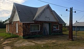
The Threatt Filling Station, at the southwestern corner of the former U.S. Route 66 and Pottawatomi Rd. about 3 miles (4.8 km) east of Luther, Oklahoma, is a filling station built around 1915. The station closed in the 1970s. It was listed on the National Register of Historic Places in 1995.

The Cities Service Station #8, at 1648 SW Boulevard in Tulsa, Oklahoma, was built in 1940 by Cities Service in the Modern Movement style. It was listed on the National Register of Historic Places in 2011.
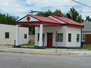
The Miami Marathon Oil Company Service Station, at 331 S. Main St. in Miami, Oklahoma, was built in 1929. It was listed on the National Register of Historic Places in 1995.

The 66 Motel in Tulsa, Oklahoma was built on the original, two-lane U.S. Route 66 around 1933 and was listed on the National Register of Historic Places in 1996. The listing included two buildings: the main or office building and a separate strip of motel rooms. The buildings are described as having "a vernacular interpretation of the Moderne style of architecture, sharing similar characteristics such as horizontal emphasis, flat roofs, asymmetrical design, and glass block windows."
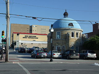
The Blue Dome Historic District in Tulsa, Oklahoma is a historic district which was listed on the National Register of Historic Places in 2016. It is a seventeen block area of commercial, industrial, and mixed-use buildings, as well as open spaces, just east of the downtown business area of Tulsa. The listing included 73 resources, including 45 contributing buildings and three contributing structures, on 59 acres (24 ha). The district thrived economically for about seventy years.

The Casa Loma Hotel in Tulsa, Oklahoma, also known as the Max W. Campbell Building or the Campbell Hotel, was built in 1927. It was listed on the National Register of Historic Places in 2010.

