This article needs additional citations for verification .(February 2023) |
Sisana | |
|---|---|
Village | |
 Sisana Location in Haryana, India  Sisana Sisana (India) | |
| Coordinates: 28°54′10″N76°51′00″E / 28.90278°N 76.85000°E | |
| Country | India |
| State | Haryana |
| Region | North India |
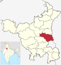
| District | Sonipat |
| Government | |
| • Type | Haryana Government |
| • Body | India |
| Population | |
• Total | N/A |
| Languages | |
| • Official | Hindi, Haryanvi |
| Time zone | UTC+5:30 (IST) |
| PIN | 131408, 131402 |
| ISO 3166 code | IN-HR |
| Vehicle registration | HR-79 |
| Website | haryana |


Sisana is a village of Sonipat district, in the Indian state of Haryana. [1] This village comes under the Tehsil of Kharkhoda. The vehicle RTO falls under the same; the vehicle numbers start from HR79 and HR10 for private vehicles.


The village was first inhabited in 1221. The nearest villages are Khanda, Sehri, Bakheta, Farmana, Gorad, Humayupur, Kharkhauda, Matindu, and Silana. It is mainly inhabited by Dahiya Jats.[ citation needed ] and Kaushik Brahmins. Sisana is now divided into two parts (panchayat): Sisana1 and Sisana2.
Most of the population in the village is Hindu. The village is surrounded by many temples, including Shivalya Mandir, Khatu Shyam Mandir, Narayan Ashram, and Dhikkan wala mandir.


The village is surrounded by ponds and fields. A Shiv Mandir is in the centre of the village, which also has a park and a pond nearby. A major source of water is a canal which is locally called Bidro/Badro.