Related Research Articles
The Battle of McDowell, also known as the Battle of Sitlington's Hill, was fought on May 8, 1862, near McDowell, Virginia, as part of Confederate Major General Stonewall Jackson's 1862 Shenandoah Valley campaign during the American Civil War. After suffering a tactical defeat at the First Battle of Kernstown, Jackson withdrew to the southern Shenandoah Valley. Union forces commanded by Brigadier Generals Robert Milroy and Robert C. Schenck were advancing from what is now West Virginia towards the Shenandoah Valley. After being reinforced by troops commanded by Brigadier General Edward Johnson, Jackson advanced towards Milroy and Schenck's encampment at McDowell. Jackson quickly took the prominent heights of Sitlington's Hill, and Union attempts to recapture the hill failed. The Union forces retreated that night, and Jackson pursued, only to return to McDowell on 13 May. After McDowell, Jackson defeated Union forces at several other battles during his Valley campaign.

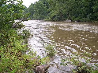
The Greenbrier River is a tributary of the New River, 162 miles (261 km) long, in southeastern West Virginia, in the United States. Via the New, Kanawha and Ohio rivers, it is part of the watershed of the Mississippi River, draining an area of 1,656 square miles (4,290 km2). It is one of the longest rivers in West Virginia.
The Cherry River is a tributary of the Gauley River in southeastern West Virginia in the United States. Via the Gauley, Kanawha and Ohio rivers, it is part of the watershed of the Mississippi River. The Cherry River drains mostly rural and forested areas and flows for much of its length through the Monongahela National Forest. Throughout its entire length the Cherry goes over a series of whitewater rapids in a mountainous setting.
The Potomac Highlands of West Virginia centers on five West Virginian counties in the upper Potomac River watershed in the western portion of the state's Eastern Panhandle, bordering Maryland and Virginia. Because of geographical proximity, similar topography and landscapes, and shared culture and history, the Potomac Highlands region also includes Pocahontas, Randolph, and Tucker counties, even though they are in the Monongahela River or New River watersheds and not that of the Potomac River.
Lunice Creek is a 7.3-mile-long (11.7 km) tributary of the South Branch Potomac River, belonging to the Potomac River and Chesapeake Bay watersheds. The creek is located in Grant County, West Virginia. Lunice Creek is created by its North and South Forks and empties into the South Branch at Petersburg.
Knapp Creek is a tributary stream of the Greenbrier River in Pocahontas County, West Virginia. Its source is east of the community of Frost on Allegheny Mountain. From its headwaters, Knapp Creek slowly flows down through farmland until its confluence with Laurel Creek at Minnehaha Springs. Downstream from the confluence of the two streams, Knapp Creek flows through Huntersville. Six miles from Huntersville, Knapp Creek empties into the Greenbrier River outside Marlinton.
Droop Mountain is a small mountain in the Allegheny Mountains on the border of Greenbrier and Pocahontas counties in southeastern West Virginia. It was the scene of one of West Virginia's most important battles during the American Civil War—the Battle of Droop Mountain.

Lowell is an unincorporated community in Summers County, West Virginia, United States. Lowell is located on the Greenbrier River, east of Hinton and southwest of Alderson. The community was first settled in 1770 and is the oldest community in Summers County.
Secondcreek is an unincorporated community in Monroe County, West Virginia, United States. Secondcreek is northeast of Union. The ZIP code for Secondcreek is 24974; however the post office was closed in 2010.
Spring Creek is an unincorporated community in Greenbrier County, West Virginia, United States. Spring Creek is located on the Greenbrier River, 3 miles (4.8 km) south of Falling Spring.
Sitlington is an unincorporated community in Pocahontas County, West Virginia, United States. Sitlington is located at the confluence of the Greenbrier River and Sitlington Creek, 13 miles (21 km) northeast of Marlinton.
Anthony Creek is a stream in the U.S. state of West Virginia. It is a tributary of the Greenbrier River.
Carpenter Run is a stream in the U.S. state of West Virginia.
Files Creek is a stream in the U.S. state of West Virginia.
Fishing Hawk Creek is a stream in the U.S. state of West Virginia.
Riffle Creek is a stream in the U.S. state of West Virginia. It is a tributary of the Tygart Valley River.
Roaring Creek is a stream in the U.S. state of West Virginia. It is a tributary of the Tygart Valley River. It rises on the western slopes of Rich Mountain, flows for approximately 13 miles, and joins the Tygart about 2 miles downstream of Aggregates, West Virginia.
Second Creek is a stream in the U.S. state of West Virginia. It is a tributary of the Greenbrier River.
Wolf Creek is a stream in the U.S. state of West Virginia. It is a tributary of Greenbrier River.
Zebs Creek is a stream in the U.S. state of West Virginia.
References
- ↑ Kenny, Hamill (1945). West Virginia Place Names: Their Origin and Meaning, Including the Nomenclature of the Streams and Mountains. Piedmont, WV: The Place Name Press. p. 583.
- ↑ U.S. Geological Survey Geographic Names Information System: Sitlington Creek