Alfred Wainwright ("A.W.") MBE was a British fellwalker, guidebook author and illustrator. His seven-volume Pictorial Guide to the Lakeland Fells, published between 1955 and 1966 and consisting entirely of reproductions of his manuscript, has become the standard reference work to 214 of the fells of the English Lake District. Among his 40-odd other books is the first guide to the Coast to Coast Walk, a 192-mile long-distance footpath devised by Wainwright which remains popular today.

The Old Man of Coniston is a fell in the Furness Fells in the Cumbria, English Lake District and was the highest point of Lancashire until local government reorganisation in 1974. It is at least 2,632.61 feet (802.42 m) high, and lies to the west of the village of Coniston and the lake, Coniston Water. The fell is sometimes known by the alternative name of Coniston Old Man, or simply The Old Man. The mountain is popular with tourists and fell-walkers with a number of well-marked paths to the summit. The mountain has also seen extensive copper and slate mining activity for eight hundred years and the remains of abandoned mines and spoil tips are a significant feature of the north-east slopes. There are also several flocks of sheep that are grazed on the mountain.

Skiddaw Little Man also called Little Man is a fell in the English Lake District, it is situated four kilometres north of the town of Keswick and reaches a height of 865 m (2,837 ft).
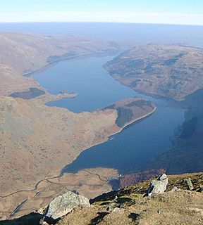
Haweswater is a reservoir in the valley of Mardale, Cumbria in the Lake District, England. Work to raise the height of the original natural lake was started in 1929. It was controversially dammed after the UK Parliament passed a Private Act giving Manchester Corporation permission to build the reservoir to supply drinking water to the city. The decision caused a public outcry because the farming villages of Measand and Mardale Green would be flooded and the valley altered forever.

High Street is a fell in the English Lake District. At 828 metres (2,718 ft), its summit is the highest point in the far eastern part of the national park. The fell is named after the Roman road which ran over the summit.

Carrock Fell is a fell in the English Lake District, situated in the northern region of the national park, 8 miles north-east of Keswick.

Ullock Pike is a fell situated in northern part of the English Lake District. It is located seven kilometres north west of Keswick and achieves a height of 691 metres. The fell sits on Skiddaw’s south western ridge along with two other fells, this ridge is regarded as the finest way to ascend Skiddaw, with Alfred Wainwright commenting:
Walna Scar is a hill in the English Lake District, lying just south of a pass of the same name in the Coniston Hills. Its summit at 2,035 feet (620 m) is only slightly higher than the pass.

Boredale sometimes known as Boardale, is a valley in Cumbria, England, it is situated within the Lake District National Park. The valley is close to the eastern shore of Ullswater and lies between the hills of Place Fell to the west and Beda Fell to the east.

Swirl How is a fell in the English Lake District. It stands between Coniston and the Duddon Valley in the southern part of the District. It rivals the Old Man of Coniston as the highest point within the traditional County Palatine of Lancashire.
Brim Fell is a fell in the English Lake District. It stands to the west of Coniston village in the southern part of the District.
Mardale is a glacial valley in the Lake District, in northern England. The valley used to have a hamlet at its head, called Mardale Green, but this village was submerged in the late 1930s when the water level of the valley's lake, Haweswater, was raised to form Haweswater Reservoir by Manchester Corporation.
The Far Eastern Fells are a group of hills in the English Lake District. Reaching their highest point at High Street they occupy a broad area to the east of Ullswater and Kirkstone Pass. Much quieter than the central areas of Lakeland they offer in general easier but less exciting walking as the fells merge mainly into the surrounding moorlands. Exceptions however are the fine rock scenery to be seen on Harter Fell, Mardale Ill Bell and High Street surrounding the head of Haweswater

Seathwaite is a small hamlet in Borrowdale valley in the Lake District of Cumbria, North West England. It is located 8 miles (13 km) southwest of Keswick at the end of a minor road that heads southwest from the hamlet of Seatoller, which is where the B5289 road begins its steep climb up the pass to Honister Hause on the boundary between Borrowdale civil parish and Buttermere civil parish.

Cartmel Fell is a hamlet and a civil parish in the South Lakeland district of Cumbria, England. In the 2001 census the parish had a population of 309, increasing at the 2011 census to 329. The village of Cartmel and Cartmel Priory are not in this parish but in Lower Allithwaite, to the south: Cartmel Fell church is about 7 miles north of Cartmel Priory.

Caer Mote is a hill of 289 metres (948 ft) in the north of the English Lake District near Bothel, Cumbria. Its summit lies just outside the boundary of the Lake District National Park and offers a view of Bassenthwaite Lake. Under the name Caermote Hill it is the subject of a chapter of Wainwright's book The Outlying Fells of Lakeland. Wainwright's route is an ascent from Bothel to the northern summit St. John's Hill at 285 metres (935 ft), continuing south to the main summit and south east to meet a minor road beside the Roman fort and follow that road north for an anticlockwise circuit. In his original book Wainwright lists the height as 920 feet, but in the 2011 2nd edition Chris Jesty corrects this to 948 feet.

Staveley-in-Cartmel is a small village and civil parish in South Lakeland district, Cumbria, England. It lies east of Newby Bridge, near the south end of Windermere, 9 miles (14 km) northeast of Ulverston. It is sometimes known as Staveley-in-Furness. Both names distinguish it from another Staveley in Cumbria. In the 2001 census the parish had a population of 428, decreasing at the 2011 census to 405.

Birks Bridge is a traditional stone-built bridge over the River Duddon in the English Lake District, in Dunnerdale-with-Seathwaite, Cumbria, standing at Grid Reference SD239995.
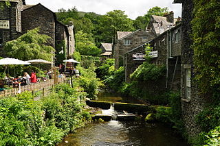
Stock Ghyll, also known as Stock Gill, Stock Gill Beck and Stock Beck, is a stream in South Lakeland, in the ceremonial county of Cumbria and the historic county of Westmorland. It flows about four miles from Red Screes through the town of Ambleside to the River Rothay. Its course includes two long-popular tourist attractions, Stockghyll Force and Bridge House. Stock Ghyll has been painted by J. M. W. Turner, John Ruskin, Kurt Schwitters, and many others. Its name derives from Old English stocc, 'tree-trunk', and Old Norse gil, 'a deep glen'.

