
Prince George's County is located in the U.S. state of Maryland bordering the eastern portion of Washington, D.C. As of the 2020 U.S. census, the population was 967,201, making it the second-most populous county in Maryland, behind neighboring Montgomery County. The 2020 census counted an increase of nearly 104,000 in the previous ten years. Its county seat is Upper Marlboro. It is the largest and the second most affluent African American-majority county in the United States, with five of its communities identified in a 2015 top ten list.

North Laurel is a census-designated place (CDP) in Howard County, Maryland, United States. The published population was 4,474 at the 2010 census. This population was substantially less than the CDP's population in 2000, and was the result of an error in defining the boundary prior to tabulation and publication of 2010 Census results. The corrected 2010 Census population is 20,259. North Laurel is adjacent to the City of Laurel, which is located across the Patuxent River in Prince George's County.

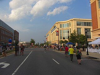
Laurel is a city in Maryland, United States, located midway between Washington, D.C. and Baltimore on the banks of the Patuxent River. While the city limits are entirely in northern Prince George's County, outlying developments extend into Anne Arundel, Montgomery and Howard counties. Founded as a mill town in the early 19th century, Laurel expanded local industry and was later able to become an early commuter town for Washington and Baltimore workers following the arrival of the Baltimore and Ohio Railroad in 1835. Largely residential today, the city maintains a historic district centered on its Main Street, highlighting its industrial past.

The Patuxent River is a tributary of the Chesapeake Bay in the state of Maryland. There are three main river drainages for central Maryland: the Potomac River to the west passing through Washington, D.C., the Patapsco River to the northeast passing through Baltimore, and the Patuxent River between the two. The 908-square-mile (2,352 km2) Patuxent watershed had a rapidly growing population of 590,769 in 2000. It is the largest and longest river entirely within Maryland, and its watershed is the largest completely within the state.

The Patuxent Wildlife Research Center is a biological research center in Maryland. It is one of 17 research centers in the United States run by the U.S. Geological Survey (USGS). The center is located on the grounds of the 12,841-acre (51.97 km2) Patuxent Research Refuge, managed by the U.S. Fish and Wildlife Service. This is the only National Wildlife Refuge in the United States that has an objective of supporting wildlife research.

Dorsey's Search is a parcel of land patented by John Dorsey of Hockley-in-the-hole (1645–1714) in Baltimore County. The 479-acre (194 ha) property adjacent to the north branch of the Patuxent river was surveyed by Richard Beard in December 1684, and granted to Dorsey in March 1696. The property lying between "Long Reach" and "Elk Ridge" was resurveyed in March 1723 to include 750 acres (300 ha). After several generations of inheritance, a series of legal disputes were held over the land by Rezin Hammond and Richard Ridgley in 1820. In 1827 the property exchanged hands to Robert Oliver, builder of Oakland Mill, who combined it with multiple properties totaling 2,300 acres (930 ha). George Gaither acquired the property in 1838. John Dorsey's grandson, "Patuxent" John Dorsey of "Dorsey's Search" built Dorsey Hall at the site.

The Belair Mansion, located in the historic Collington area and in Bowie, Maryland, United States, built c. 1745, is the Georgian style plantation house of Provincial Governor of Maryland, Samuel Ogle. Later home to another Maryland governor, the mansion is listed on the National Register of Historic Places.

Montpelier Mansion, sometimes known as the Snowden-Long House, New Birmingham, or simply Montpelier, is a five-part, Georgian style plantation house located south of Laurel in Prince George's County, Maryland. It was most likely constructed between 1781 and 1785. Built by Major Thomas Snowden and his wife Anne, the house is now a National Historic Landmark operated as a house museum. The home and 70 acres (28 ha) remain of what was once a slave plantation of about 9,000 acres (3,600 ha).
Fulton is a census-designated place located in southern Howard County, Maryland, United States. As of the 2010 census it had a population of 2,049.
Sotterley Plantation is a historic landmark plantation house located at 44300 Sotterley Lane in Hollywood, St. Mary's County, Maryland, USA. It is a long 1+1⁄2-story, nine-bay frame building, covered with wide, beaded clapboard siding and wood shingle roof, overlooking the Patuxent River. Also on the property are a sawn-log slave quarters of c. 1830, an 18th-century brick warehouse, and an early-19th-century brick meat house. Farm buildings include an early-19th-century corn crib and an array of barns and work buildings from the early 20th century. Opened to the public in 1961, it was once the home of George Plater (1735–1792), the sixth Governor of Maryland, and Herbert L. Satterlee (1863–1947), a New York business lawyer and son-in-law of J.P. Morgan.

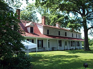
Snow Hill is a manor house located south of Laurel, Maryland, off Maryland Route 197, in Prince George's County. Built between 1799 and 1801, the 1+1⁄2-story brick house is rectangular, with a gambrel roof, interior end chimneys, and shed dormers. It has a center entrance with transom and a small gabled porch. A central hall plan was used, with elaborate interior and corner cupboards. The original south wing was removed and rebuilt, and the home restored in 1940. The Late Georgian style house was the home of Samuel Snowden, part owner of extensive family ironworks, inherited from his father Richard Snowden. and is now owned and operated by the Maryland-National Capital Park and Planning Commission as a rental facility.

Troy, also known as Troy Hill Farm, is a historic slave plantation home located at Elkridge, Howard County, Maryland, United States. It is associated with the prominent Dorsey family of Howard County, who also built Dorsey Hall.

DuVal High School (DHS) is a comprehensive science and technology public magnet high school in the Seabrook census-designated place in unincorporated Prince George's County, Maryland, United States, with a Lanham postal address. Prior to 2010 the U.S. Census Bureau defined the area containing DuVal High as being within the Goddard CDP.

Whiskey Bottom Road is a historic road north of Laurel, Maryland that traverses Anne Arundel and Howard Counties in an area that was first settled by English colonists in the mid-1600s. The road was named in the 1880s in association with one of its residents delivering whiskey after a prohibition vote. With increased residential development after World War II, it was designated a collector road in the 1960s; a community center and park are among the most recent roadside developments.
Richard Snowden (1688–1763) was the grandson of Richard Snowden Sr (1640–1711), one of Maryland's early colonists, who arrived in 1658. By Articles of Agreement dated July 5, 1705, Snowden and four other partners – Joseph Cowman, Edmund Jenings, John Galloway, and John Prichard – founded the Patuxent Iron Works on the site of Maryland's oldest iron forge. Together they founded one of Maryland's first industries, and settled the land now known as Laurel and Sandy Spring, Maryland.
Duvall Bridge is an historic single-lane bridge over the Patuxent River near Laurel, Maryland.
Birmingham Manor was a historic slave plantation home located in Anne Arundel County, Maryland
The Duvall Farm was a historic farm located in North Laurel, Howard County, Maryland, now the site of Coastal Sunbelt Produce.
Oaklands or Contee was a slave plantation owned by the Snowden family, and remains as a historic home surrounded by residential development.
Cremona Farm is a 1275-acre estate comprising a 650-acre former slave plantation and surrounding lands in Mechanicsville, Maryland, on the west bank of the Patuxent River. The estate is under perpetual conservation easements with the Maryland Environmental Trust and Patuxent Tidewater Land Trust, and owned by a non-profit foundation, the Cremona Foundation.


