
Fall Creek is a village in Eau Claire County, Wisconsin, United States. The population was 1,315 at the 2010 census. The village is bordered by the Town of Lincoln.
Clement Town is a cantonment town in Dehradun, Dehradun district in the state of Uttarakhand, India. Clement Town is seven kilometres (4.3 mi) from the clock tower in main city of Dehradun. Saharanpur and Haridwar are 65 and 54 km respectively. It also borders Rajaji National Park and is home to several renowned institutions. Schools such as Raja Ram Mohan Roy Academy and St. Mary's are in the neighbourhood. Country singer Bobby Cash resides in Clement Town.
Kirtinagar is a town and a Nagar Panchayat and a Taluk in Tehri Garhwal district in the Indian state of Uttarakhand.

Ramtek is a city and municipal council in Nagpur district of Maharashtra, India.

Adiralu is a village in the southern state of Karnataka, India. It is located in the Hiriyur taluk of Chitradurga district in Karnataka.
Adnur is a village in the southern state of Karnataka, India. It is located in the Navalgund taluk of Dharwad district.
Agatahalli is a village in the southern state of Karnataka, India. It is located in the Pandavapura taluk of Mandya district in Karnataka.

Akhandhalli is a village in the southern state of Karnataka, India, located in the Jevargi taluk of Kalaburagi district.
Akkigund is a village in the southern state of Karnataka, India. It is located in the Shirhatti taluk of Gadag district in Karnataka.
Sirukadambur is a village in the Sendurai taluk of Ariyalur district, Tamil Nadu, India.
Andami is a village in the Madukkur block, Pattukkottai Taluk of Thanjavur district, Tamil Nadu, India. It is located 48 KM towards South from District head quarters Thanjavur. 4 KM from Madukkur. 347 KM from State capital, Chennai, and is one of the 32 villages of Musugundan Community.
Bavajikkottai is a village in the Pattukkottai taluk of Thanjavur district, Tamil Nadu, India.
Bacholi is a village in Satara district in the southern state of Maharashtra, India.
Belo Polje is a village in the municipality of Raška, Serbia. According to the 2002 census, the village has a population of 48 people.
Chandanmatti is a village in Dharwad district of Karnataka, India.
Halligeri is a village in Dharwad district of Karnataka, India.
Kotagudda is a village and nidagal hobli [Pavagada]] tq, Tumkur district, state of Karnataka in India, it is situated 13 km away from Pavagada, Grama Panchayat includes Shaila pur Arakyathan Halli and more villages. There is road which connects to Chitradurga and YN Hosakote. According to the 2011 census it has a population of 3414 living in 771 households. Its main agriculture product is groundnut growing.

Pandanallur is a Suburban of Kumbakonam in the Thiruvidaimarudur taluk of Thanjavur district. It is north of Aduthurai. Pandanallur is a historically important village and is known for its Pasupatiswarar Temple and Adikesava Perumal temple. The Pandanallur style of Bharatanatyam also traces its origin to Pandanallur.
Kudalgi is a village in Dharwad district of Karnataka, India.
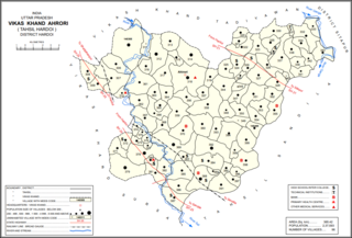
Ahrori, also spelled Ahirori, is a village and corresponding community development block in Hardoi district of Uttar Pradesh, India. Located 24 km from the city of Hardoi, it hosts a regular market and hosts a Babaji festival on Asadha Sudi 15 dedicated to worship of the goddess Devi. The village has two primary schools and one clinic, as well as a public library and a sub post office. As of 2011, the population of Ahrori is 8,382, in 1,329 households.