Solomon Township, Cloud County, Kansas

Last updated
Solomon Township
Township
Map highlighting Solomon Township, Cloud County, Kansas.svg
Location in Cloud County
Coordinates: 39°22′20″N097°52′21″W / 39.37222°N 97.87250°W / 39.37222; -97.87250 Coordinates: 39°22′20″N097°52′21″W / 39.37222°N 97.87250°W / 39.37222; -97.87250
Country United States
State Kansas
County Cloud
Area
  Total 54.36 sq mi (140.8 km2)
  Land 54.36 sq mi (140.8 km2)
  Water 0 sq mi (0 km2)  0%
Elevation 1,329 ft (405 m)
Population (2000)
  Total 664
  Density 12.2/sq mi (4.7/km2)
GNIS feature ID 0475979

Solomon Township is a township in Cloud County, Kansas, USA. As of the 2000 census, its population was 664.

A civil township is a widely used unit of local government in the United States that is subordinate to a county. The term town is used in New England, New York, and Wisconsin to refer to the equivalent of the civil township in these states. Specific responsibilities and the degree of autonomy vary based on each state. Civil townships are distinct from survey townships, but in states that have both, the boundaries often coincide and may completely geographically subdivide a county. The U.S. Census Bureau classifies civil townships as minor civil divisions. Currently, there are 20 states with civil townships.

Cloud County, Kansas county in Kansas, United States of America

Cloud County is a county located in the U.S. state of Kansas. As of the 2010 census, the county population was 9,533. Its county seat and most populous city is Concordia.

Kansas State of the United States of America

Kansas is a U.S. state in the Midwestern United States. Its capital is Topeka and its largest city is Wichita, with its most populated county being Johnson County. Kansas is named after the Kansa Native American tribe, which inhabited the area. The tribe's name is often said to mean "people of the (south) wind" although this was probably not the term's original meaning. For thousands of years, what is now Kansas was home to numerous and diverse Native American tribes. Tribes in the eastern part of the state generally lived in villages along the river valleys. Tribes in the western part of the state were semi-nomadic and hunted large herds of bison.

Contents

Geography

Solomon Township covers an area of 54.36 square miles (140.8 km2) and contains one incorporated settlement, Glasco.

Glasco, Kansas City in Kansas, United States

Glasco is a city in Cloud County, Kansas, United States. As of the 2010 census, the city population was 498.

The streams of Cris Creek, First Creek, Fisher Creek, Lost Creek, Second Creek and Third Creek run through this township.

Related Research Articles

Allegheny River river in northeastern United States

The Allegheny River is a principal tributary of the Ohio River; it is located in the Eastern United States. The Allegheny River joins with the Monongahela River to form the Ohio River at the "Point" of Point State Park in Downtown Pittsburgh, Pennsylvania. The Allegheny River is, by volume, the main headstream of both the Ohio and Mississippi Rivers.

Calhoun County, Michigan county in Michigan, US

Calhoun County is a county in the U.S. state of Michigan. As of the 2010 census, the population was 136,146. The county seat is Marshall. The county was established on October 19, 1829 and named after John C. Calhoun, who was at the time Vice President under Andrew Jackson, making it one of Michigan's Cabinet counties. County government was first organized March 6, 1833.

Hanover Township, Luzerne County, Pennsylvania Township in Pennsylvania, United States

Hanover Township is a township in Luzerne County, Pennsylvania, United States. As of the 2010 census, the population was 11,076, making it the most populous township in the county.

Pickrelltown, Ohio Unincorporated community in Ohio, United States

Pickrelltown is an unincorporated community in Logan County, Ohio.

Oxford Circle, Philadelphia Neighborhood of Philadelphia in Philadelphia County, Pennsylvania, United States

Oxford Circle is a neighborhood in the lower Northeast section of Philadelphia, Pennsylvania, United States. Its namesake is the much used traffic circle at Roosevelt Boulevard and Oxford Avenue. The Oxford Circle neighborhood has traditionally included the areas up to Rhawnhurst and Mayfair but does not really have a fixed boundary other than in publications about Philadelphia which are of a public relations or informational nature.

Wilkins Mill Covered Bridge place in Indiana listed on National Register of Historic Places

The Wilkins Mill Covered Bridge is north of Rockville, Indiana. The single span Burr Arch Truss covered bridge structure was built by William Hendricks in 1906. The bridge is 120 feet (37 m) long, 16 feet (4.9 m) wide, and 13 feet (4.0 m) high.

Solomon Township, Graham County, Kansas Township in Kansas, United States

Solomon Township is a township in Graham County, Kansas, USA. As of the 2000 census, its population was 209.

Browns Creek Township, Jewell County, Kansas Township in Kansas, United States

Browns Creek Township is a township in Jewell County, Kansas, USA. As of the 2000 census, its population was 64.

Prairie Township, Jewell County, Kansas Township in Kansas, United States

Prairie Township is a township in Jewell County, Kansas, USA. As of the 2000 census, its population was 172.

Brush Creek Township, Washington County, Arkansas Township in Arkansas, United States

Brush Creek Township is one of thirty-seven townships in Washington County, Arkansas, USA. As of the 2010 census, its unincorporated population was 2,877.

Cove Creek Township, Washington County, Arkansas Township in Arkansas, United States

Township of Cove Creek is one of thirty-seven townships in Washington County, Arkansas, USA. As of the 2000 census, its total population was 683. Part of Devil's Den State Park is located in Cove Creek Township.

Mill Creek is a tributary of the Susquehanna River in Luzerne County, Pennsylvania in the United States. It is 8.7 miles (14.0 km) long. Its watershed is approximately 36 square miles in area. The creek flows through Plains Township, Bear Creek Township, and Wilkes-Barre.

Lees Creek Township, Washington County, Arkansas Township in Arkansas, United States

Lee's Creek Township is one of thirty-seven townships in Washington County, Arkansas, USA. As of the 2000 census, its total population was 640.

Solomon Creek tributary of the Susquehanna River

Solomon Creek is a tributary of the Susquehanna River in Luzerne County, Pennsylvania, in the United States. It is approximately 8.8 miles (14.2 km) long and flows through Fairview Township, Hanover Township, and Wilkes-Barre. The creek is affected by acid mine drainage and has significant loads of iron, aluminum, and manganese. The creek's named tributaries are Spring Run, Sugar Notch Run, and Pine Creek. The Solomon Creek watershed is located in the Anthracite Valley section of the ridge-and-valley geographical province. Major rock formations in the watershed include the Mauch Chunk Formation, the Spechty Kopf Formation, and the Catskill Formation.

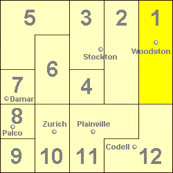
Township 1, Rooks County, Kansas Township in Kansas, United States

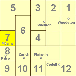
Township 1 is a township in Rooks County, Kansas, USA. Woodston is the largest population center in Township 1.

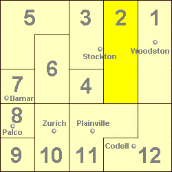
Township 2, Rooks County, Kansas Township in Kansas, United States

Township 2 is a township in Rooks County, Kansas, USA.

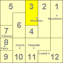
Township 3, Rooks County, Kansas Township in Kansas, United States

Township 3 is a township in Rooks County, Kansas, USA. Stockton is the largest population center in Township 3.

Township 6, Rooks County, Kansas Township in Kansas, United States

Township 6 is a township in Rooks County, Kansas, USA.

Township 7, Rooks County, Kansas Township in Kansas, United States

Township 7 is a township in Rooks County, Kansas, USA. Damar is the largest population center in Township 7.

References